Tag Archive: volcano


With deep condolences to the affected families and friends of those lost or injured, with respect, a tracing of safety fault. Haere, haere, haere, ngaa hoa mate o Aotearoa.

Whakaari/White Island – patient status – Ministry of Health – Manatū Hauora
Urgency of daily EQNZ risk – Whakaari / White Island, 9 December 2019 – a cautionary analysis:

If the significant eruptive event of 9 November 2019 (that kicked the 6-month developing volcanic process up another gear, leading to a deadly harmful “moderate” event of 9Dec2019) was noticed in itself, as a warning for everyone to keep clear for a month, what record is apparent of that? ..


Nine whole days later comes the formal, hyper-cautious response (conservative of what, foremost – business as usual, scientific reputation, political relationships and quiescent public mood …? ):

Whakaari/White Island: Background activity increases further
Volcanic Alert BulletinWI – 2019/09
Mon Nov 18 2019 12:00 PM; White Island Volcano
Volcanic Alert Level is raised to 2
Aviation Colour Code is raised to Yellow
“Volcanic unrest continues at Whakaari/White Island and some monitored parameters show further increases in activity. Hazards on the island are now greater than during the past few weeks, and the Volcanic Alert Level is raised to Level 2… In the past few weeks, the level of volcanic tremor has also increased from weak to moderate strength… The number or locations of earthquakes beneath or near the island have not changed… the monitored parameters are just above the expected range for minor volcanic unrest and associated hazards. The patterns of signals are similar to those through the 2011—2016 period and suggest that Whakaari/White Island may be entering a period where eruptive activity is more likely than normal… Volcanic Alert Level 2 is mostly associated with unrest hazards on the volcano and could include eruptions of steam, gas, mud and rocks. These eruptions can occur with little or no warning.”

Whakaari/White Island: Moderate volcanic unrest continues
Volcanic Alert BulletinWI – 2019/10
Mon Nov 25 2019 2:00 PM; White Island Volcano
Volcanic Alert Level remains at 2
Aviation Colour Code remains at Yellow
“There has been no change in activity at the volcano after the deep magnitude 5.9 earthquake, that occurred beneath eastern Bay of Plenty on Sunday 24 November… volcanic tremor remains at moderate levels. There have been few earthquakes near the island… fountaining is regularly throwing mud a few metres into the air at the vent but at current levels does not pose a hazard to visitors… in the expected range for moderate volcanic unrest and associated hazards. The monitoring observations are similar to those seen in the more active 2011—2016 period and suggest that Whakaari/White Island may be entering a period where eruptive activity is more likely than normal… Level 2 is mostly associated with unrest hazards on the volcano and could include eruptions of steam, gas, mud and rocks. These eruptions can occur with little or no warning.”

Whakaari/White Island: Moderate volcanic unrest continues
Volcanic Alert BulletinWI – 2019/11
Tue Dec 3 2019 1:00 PM; White Island Volcano
Volcanic Alert Level remains at 2
Aviation Colour Code remains at Yellow
“Explosive gas and steam-driven mud jetting continues from the active vent area… style of activity has been present since late September, although it is occurring more frequently now. No volcanic ash is being produced. Volcanic gas emission and seismic activity continue to remain elevated… Volcanic tremor also remains at moderate levels in the last week… level of activity is variable and remains within the range expected for moderate volcanic unrest. While the activity is contained to the far side of the lake, the current level of activity does not pose a direct hazard to visitors… some similarities with those seen during the 2011-2016 period when Whakaari/White Island was more active and stronger volcanic activity occurred… may be entering a period where eruptive activity is more likely than normal… Volcanic Alert Level 2 is mostly associated with unrest hazards on the volcano and could include eruptions of steam, gas, mud and rocks. These eruptions can occur with little or no warning.”

The two highlighted phrases in the above paragraph stand in direct contradiction to each other. Interpretation of immediate risk was thus loosely allowed to fail.

Language gaps and repetition are features of these three most recent reports. Leading up to them, in summary, there were two earthquake swarms earlier in the year (kept in silo). Then three other indicators were also too casually discounted: the rising crater lake, temperature and gas levels – “the highest [gas] value recorded since 2013 and the 2nd highest since regular measurements began in 2003”. Read all Volcanic Alert Bulletins here: geonet.org.nz/volcano/vab/all.

It seems to me, the greatest problem exists where the category “moderate” volcanic activity is one relating to (commercial) aviation risk, where at (human) ground level it can be a deadly risk and truly immoderate.

The next greatest problem, I would say, was de-prioritising this hazard, under the present conditions, from a Monday inspection cycle to a Tuesday, without which the Monday tragedy may have been avoided. – Who made that GNS decision, when and why? At least please clarify the inspection and reporting schedule around this hazard.

Thirdly, ‘the international best practise’.., if that is what determines this, of treating each and every seismic event as a unique and unrelated item (‘in a silo’), may have limited perception of this emerging volcanic crisis. Can this quake isolation approach be explained or reviewed at all?

GNS-defined no-go hazard zone, ‘as it would have applied on 9Dec2019’, in hindsight Thursday:

GNS hazard exclusion zone 2019-12-12

GNS Whakaari / White Island hazard exclusion zone 2019-12-12

Generally, we need to support science and scientists better and much more – for at times they provide our only lifeline. Help them to improve their work for us all.

The main question I have for GNS, is, why no particular study or escalation of alert around the 28Oct2019 Whakaari earthquake swarm? which could have averted tragedy, echoed on 6Dec19:

earthquakes near White Island over the past 2 months

Earthquakes near White Island over the past 2 months. Graphic source: geonet.org.nz/volcano/eqstats/whiteisland


Earthquakes near White Island over the past 2 months.

Earthquakes near White Island over the past 2 months

“The eruption is not caused by magma, but by steam, and this is much harder to track in our current monitoring systems.”[1]

“GNS also makes three monthly visits to test water, gas and soil, as well as to make surveys of surface deformation.”[2]

“It’s tapu because of the fact that we have our distinguished dead there.”[3]

“Tāupo volcanic zone.. runs from Ruapehu to White Island.. measured as some of the most productive volcanism on earth”. [4]

Godspeed and safe travels to the NZDF and NZPolice recovery operation 13.12.19

“In 2012, a lava dome was spotted and the alert level raised from one to two.. lava dome growth can be accompanied by explosive eruptions and could impact people on the island” [5]

“Overnight web camera images recorded a glow from the vent area, confirming high heat flow” [6]

Yet lower earthquake frequency leads to a lowering to “35-50% chance (medium likelihood) of an eruption occurring that could impact outside of the marked vent area within the next 24 hours” [7]

With sadness, “Police confirm another death“, taking fatal incident toll to 17 (so far), 14Dec2019

With sadness, “A sixteenth person has died” officially, taking fatal incident toll to 18, 15Dec2019

With sadness, the “Seventeenth person dies” officially, taking fatal incident toll to 19, 23Dec2019

With sadness, the “Official death toll rises to 18“, taking fatal incident toll to 20, 13Jan2020

Whakaari / White Island eruption: two missing people officially listed as dead, 23Jan2020

With sadness, the official “Whakaari/White Island eruption: Death toll rises to 21“, 29Jan2020

Very sadly, “Police raise Whakaari eruption death toll to 22 after death overseas in July“, 26Nov2020 + panel audio

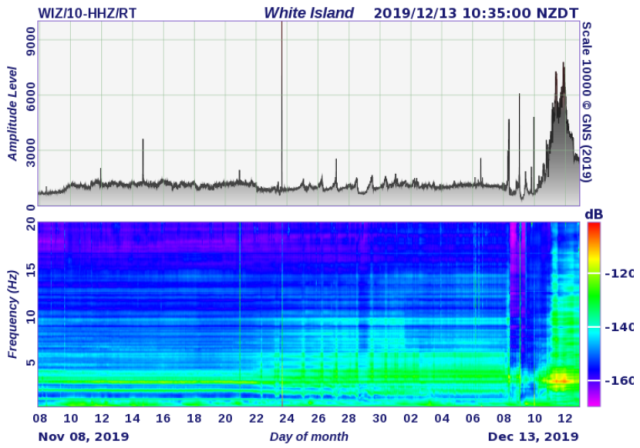
13Nov-13Dec19 quake intensity Whakaari

13Nov-13Dec19 quake intensity Whakaari


Comparing this graphic to earliest released in the sequence, showing tail of 9Nov2019 event only:
10Nov-10Dec19 quake intensity Whakaari

10Nov-10Dec19 quake intensity Whakaari

If GNS estimates are correct, and this was just a typical ‘Whakaari cough’, then there will be no significant eruption soon following the current anomalous (markedly quiet) seismic situation:

The reason being, the risen magma has burnt off (evaporated) its water table cap and punched through the rock overlay already, allowing free lava expansion movement and degassing thanks to the phreatic explosion of 9Dec. See also Deep Earth Carbon Degassing Project re “order of magnitude uncertainty in current volcanic/tectonic carbon outgassing makes answering fundamental questions about the global carbon budget virtually impossible”.

Caring for yourself and others before, during and after a crisis – New Zealand Red Cross

Some full documentation of events and context are (draft listing of information sources) at:
GeoNet.org.nz Whakaari/White Island – Updates & /volcano/monitoring/whiteisland +
RNZ.co.nz/news/Whakaari-White-Island/ & RNZ news update blog 12/12 / 13/12 etc & Aotearoa sits over two continental plates, and Whakaari / White Island is just one of many volcanoes &
Tourists visiting New Zealand need to be well-informed of risks, professor says &
[1] Why White Island erupted and why there was no warning &
[2] Whakaari / White Island eruption: What scientists say about the volcano &
[3] The beauty and the menace of Whakaari &
[4] When Aotearoa heats up from below etc RNZ stories +
Why White Island erupted and why there was no warning The Conversation +
Whakaari/White Island volcano: Unlucky timing or unsafe system? Stuff +
White Island: A stark, dangerous and wondrous place stuff.co.nz/travel/destinations 5Nov2017 +
Whakaari/White Island: Tourism operators offering unregistered adventures risk $50,000 fines stuff.co.nz/business 14Dec2019 +
[5] A level two sense of security Newsroom +
[6] VOLCANIC ALERT BULLETINWI – 2019/22 Sat Dec 14 2019 11:30 AM; White Island Volcano &
[7] Whakaari/White Island likelihood of future eruption: Update #4 GeoNet +
nzherald.co.nz many articles +
White Island Tours by boat (suspended) +
Volcanic Air – White Island ACTIVE VOLCANO WALKING TOUR (suspended) +
White Island Volcano Adventure Kahu NZ (formerly Frontier Helicopters) Frontier Group NZ +

+ Criticising experts in the wake of tragedy Stuff, 17 Dec 2019, a thoughtful note
+ etc. etc. Then
White Island volcano victims to sue Royal Caribbean RNZ, 27 April 2020.
Update: WorkSafe charges 13 parties over Whakaari eruption RNZ, 30 November 2020

Noting a return of readers to my blog today, probably looking for New Zealand earthquake analysis, I will rattle this post off quickly, as a catch-up on a previously strong theme to my writing. Then I will take a good long walk to relax. As should we all.

Having accurately forecast, to within 50 minutes, a magnitude 4.7 Christchurch earthquake yesterday, what are my afterthoughts about this? Under-earth events continue for the country and are detailed here: #Masterton‬ mag 5.2 ‪#‎eqnz‬ this morning is not alone..”[1] (Read research at footnote link). The title is only more fitting, a month to the day since it was written, when there have been two 5.2 magnitude earthquakes, this new morning. (Ironically, says the Moon Man?)

Stunning, really. Awesome Earth!

But what is the big picture, if I am asked?

Well, it’s not good. Not for New Zealand, one of the newest land masses and nations on the planet – it is likely to have to start again. In our lifetime? It seems / I would say, perhaps yes. Because a 330-year Alpine Fault cycle is sitting at year 299, approximately.

The tectonic motion we have begun to experience as a constant factor of the post-colonial state has the capacity to practically destroy it. In my opinion. A catastrophe so large is built into this land, Aotearoa – Land of the Long White [volcanic] Cloud – that it will surely cripple us one day. Soon? Hard to say. Why? It looks like this:

Current south-east/central North Island quakes are signs that the Australian Plate it is on is moving, a little bit more. When it finally gets going properly it will be a huge leap south-east, and this will spread the central plateau / Kermadec Arc enough for the Taupo super-volcano to explode again. That will obliterate the central North Island and disable both Auckland and Wellington.

What will initiate this calamity, however, will be almost as bad for the South Island  – a magnitude 8+ slippage of the Alpine Fault, disabling Christchurch and the then-isolated West Coast. This (long-term) ‘regular’ event constitutes the letting-off of the not-quite slow-moving tectonic brake, that is the Southern Alps, that keeps this geological system ‘stable’. A relative term. Long calm will resettle again, after many many large and small aftershocks.

Will Otago-Southland be left standing to pull us through? Let us hope so.

There is no way we can recover from this imminent (in our lifetime?) surety without massive international support and massive sacrifice of sovereignty.

Let us prepare for that transitional step now. However we are best able to.

But it may be that the next magnitude 8+ Alpine Fault earthquake does not release Taupo super-volcano.[2]  Let us hope so. ‘Not yet please.’  We are not ready. …

Is the Taupo volcano on a 5, 6 or 7 Alpine Fault-slip cycle? Some decade on from now, all New Zealand will be discovering this, as-yet hidden fact, together. It will be our darkest hour. Human spirit will pull through.

Kia kaha. Kia ora. Waimarie.

[1] facebook.com/photo.php?fbid=10209826325001836&set=a.1294734535479.2045005.1443783772&type=3

[2] “1800 years ago Taupo volcano in New Zealand had the largest volcanic eruption in the world for the last 5000 years.” sott.net/article/249473-Is-The-Super-Volcano-Taupo-in-New-Zealand-Awakening and see wikipedia.org/wiki/Taupo_Volcano “The main pyroclastic flow devastated the surrounding area, climbing over 1500 metres (5000 ft) to overtop the nearby Kaimanawa Ranges and Mount Tongariro, and covering the land within 80 kilometres (50 mi) with ignimbrite from Rotorua to Waiouru. Only Ruapehu was high enough to divert the flow.”

“Possibility of further eruptions on White Island remains high” 10 May 2016 m.nzherald.co.nz/nz/news/article.cfm?c_id=1&objectid=11636672

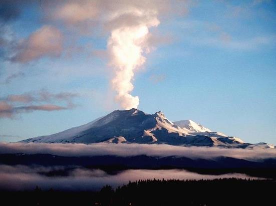
“Mt Ruapehu still shaking” – top closed to public radionz.co.nz/news/national/303667/mt-ruapehu-still-shaking

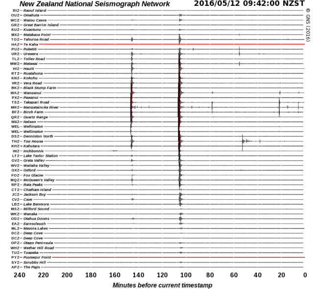
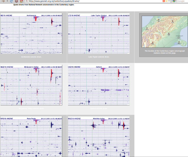
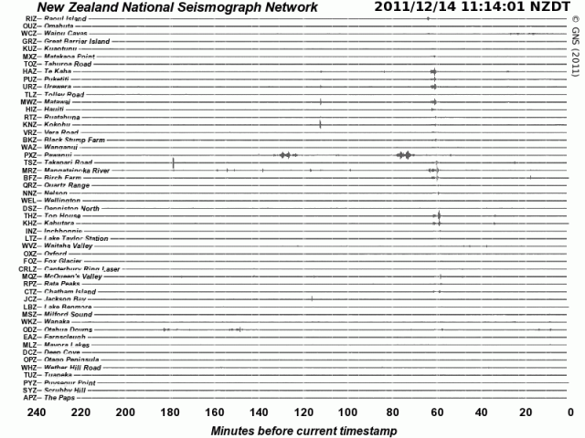
“Aggressive 4.7 Christchurch shake centred close to February 22, 2011 earthquake”  stuff.co.nz/national/79890087/earthquake-rattles-christchurch and five hours later a “‘Strong’ earthquake shakes lower North Island” stuff.co.nz/national/79892918/Strong-earthquake-shakes-lower-North-Island 12 May 2016 – graphic, GeoNet.org.nz/quakes/drums:

120516b-NSN-drums-Masterton4.7-5.2

Update 30/5/2016

Scientists prepare for Lake Taupo eruption

“A team of researchers is studying the volcano so better response plans can be put in place in case of a large eruption. The Earthquake Commission said damage from the last time the volcano erupted – almost 1800 years ago – would be large enough to destroy the central North Island…”
radionz.co.nz/news/regional/305214/scientists-prepare-for-lake-taupo-eruption

Understand that the Taupo Volcanic Zone, stretching from Mount Ruapehu to north of White Island, marks the southern pin of the broad Kermadec Arc and basin, a massive slow-spreading rift in the Earth that forever thins its crust. From this steady motion – eastwards, of the Australian Plate – re-eruption of Taupo Volcano is inevitable. It isn’t the centre of the North Island for no reason – it explains why the island is above water. https://en.wikipedia.org/wiki/Taupo_Volcanic_Zone

Subduction Zone diagram

Subduction Zone diagram

https://en.wikipedia.org/wiki/Lau_Basin + Graphic: https://en.wikipedia.org/wiki/Back-arc_basin

The 5th most explosive volcano event known to human scientific records:
Name: Whakamaru
Zone: Taupo Volcanic Zone
Location: New Zealand, North Island
Notes: Whakamaru Ignimbrite/Mount Curl Tephra
Years ago (approx.): 340,000
Ejecta bulk volume (approx.): 2,000 km³
https://en.wikipedia.org/wiki/Supervolcano#VEI_8

Later, “Earth’s most recent eruption reaching VEI-8, the highest level on the Volcanic Explosivity Index” https://en.wikipedia.org/wiki/Taupo_Volcanic_Zone

“The Ōruanui eruption (about 26,500 years ago) covered much of the central North Island with ignimbrite, up to 200 metres deep. Ash fallout was spread by the wind over the entire North Island, much of the South Island, and a large area east of New Zealand, including the Chatham Islands. About 1,200 cubic kilometres of pumice and ash were rapidly ejected. This caused a large area of land to collapse, forming the caldera basin now filled by Lake Taupō.”

…”Big bang – The Ōruanui eruption was so enormous that it is hard to visualise. In only a few days or weeks it ejected enough material to construct three Ruapehu-sized cones. After the eruption, the new lake gradually filled to a level 140 metres above the present lake. The lake broke out to the north, resulting in a huge flood. For several thousand years the Waikato River flowed northwards into the Hauraki Gulf, but it later changed its course to flow through the Hamilton lowlands to the Tasman sea.”

Then, …”Taupō eruption – The most recent major eruption of Taupō volcano took place in late summer–early autumn around 200 AD, from vents near Horomatangi Reefs (now submerged). The eruption produced a towering ash column, resulting in tephra-fall deposits over a wide area from Hamilton to Gisborne. The airfall deposits were much thicker to the east of Taupō because the eruption column was blown in that direction by strong westerly winds. The eruption column was followed by a devastating pyroclastic flow, blanketing a roughly circular area within 80 kilometres of Lake Taupō with ignimbrite, and destroying all life in its path. The ground-hugging pyroclastic flow appears to be one of the most powerful ever recorded, and was able to overtop Mt Tongariro and the Kaimanawa mountains, climbing 1,500 metres in a matter of minutes. The outlet of Lake Taupō was again blocked during the eruption, and the lake level rose to 34 metres above its present height, forming a widespread terrace. The lake eventually broke out in a huge flood whose effects can be traced for over 200 kilometres downstream, and include boulder beds and buried forests.”
http://www.teara.govt.nz/en/volcanoes/page-5

That is, the same most recent was, the ‘Hatepe eruption’: “considered New Zealand’s largest eruption during the last 20,000 years.. ejected some 120 km3 (29 cu mi).. of which 30 km3 (7.2 cu mi) was ejected in the space of a few minutes. This makes it one of the most violent eruptions [on Earth] in the last 5000 years.. Tsunami deposits of the same age have been found on the central New Zealand coast, evidence that the eruption caused local tsunamis” https://en.wikipedia.org/wiki/Hatepe_eruption

“Radiocarbon dating indicates an uneven spacing of Taupo’s eruptions, from decades to thousands of years apart. This makes it difficult to forecast when the next eruption will occur and how big it will be.” http://www.teara.govt.nz/en/volcanoes/page-5

http://hisz.rsoe.hu/alertmap/index2.php#supv

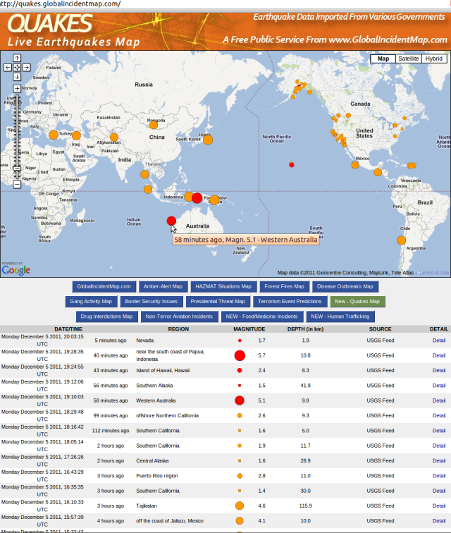
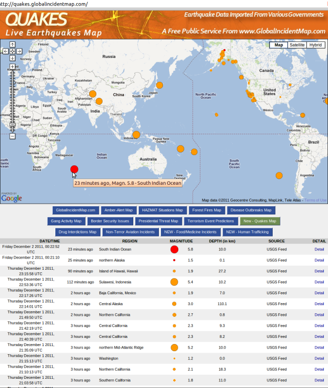
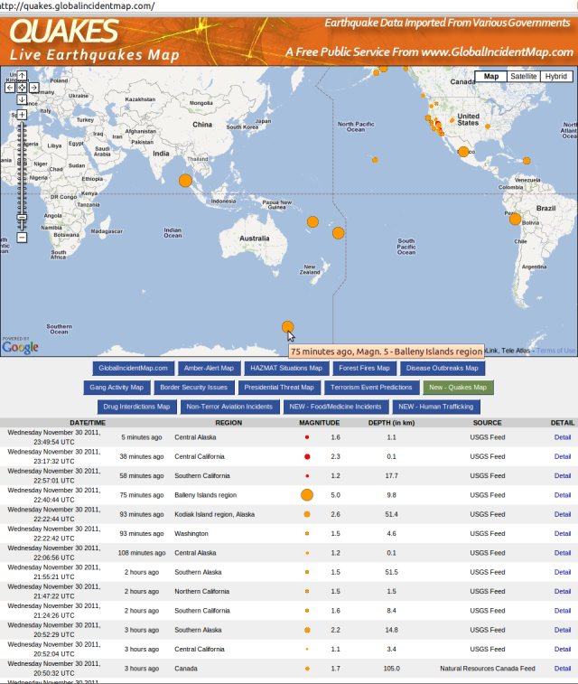
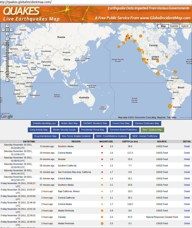
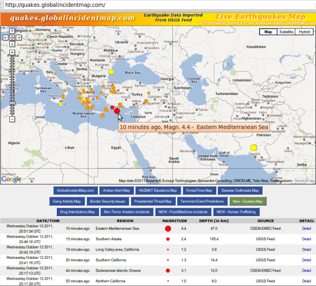
http://quakes.globalincidentmap.com

http://www.emsc-csem.org/Earthquake

Update 4/6/2016
“Magma chamber blamed for Bay of Plenty earthquake swarm.. study found the previously unrecognised magma body caused several thousand small earthquakes between 2004 and 2011.. expansion of the molten rock chamber approximately 9km below Matata has pushed up 400 square kilometres of land by 40cm.. something was accumulating at a depth of around 9.5 to 10km beneath the Earth’s surface.. The magma body could have been there for centuries or more.. The area was a ‘rift zone’ where over time the crust had been stretched and thinned – but it was not clear whether the crust was already thin, or the magma made it thin. ‘It is probably a thinner crust than the average you’d find elsewhere.. But what happens is as you stretch the crust and the hot rocks beneath come to a shallower depth, as they become shallower they get less pressure, which actually then enables them to melt and become magma. That magma, because it’s less buoyant than the surrounding rock, it then wants to percolate up through [into the crust]'”, RNZ – radionz.co.nz/news/national/305592/magma-buildup-blamed-for-quakes & Science Advances article, “results suggest that the continued growth of a large magmatic body may represent the birth of a new magma chamber on the margins of a back-arc rift system” – advances.sciencemag.org/content/2/6/e1600288.full
“A huge deposit of magma has been detected just 9km below a small North Island town – and scientists say it may be causing earthquakes. Matata is nestled between Tauranga and Opotiki, and new research using satellite image, GPS data and surveying has revealed the molten secret. The level of the town has been steadily rising over the last few years – up to 10mm per year of uplift, but it is now beginning to slow to about four-five millimetres per year. Scientists are confident there will not be an eruption in the near future, but say they will continue to monitor the magma field”, TV1 – tvnz.co.nz/one-news/new-zealand/huge-field-molten-magma-found-under-north-island-town
“Rising magma to blame for swarm of quakes”, TV3 – newshub.co.nz/nznews/rising-magma-to-blame-for-swarm-of-quakes-2016060400
“Volcano status and notifications come to the GeoNet app – With the flurry of volcano activity last month, we’re pleased to add some new features to the GeoNet app so you can keep an eye on them, too”, GNS 30May2016 –
info.geonet.org.nz/display/appdata/2016/05/30/Volcano+status+and+notifications+come+to+the+GeoNet+app

Update 17/6/2016

Lake Tarawera water warning, 10 Jan 2015 – “People are being warned not to drink water from Lake Tarawera or swim in it after locals noticed the water was discoloured. It was reported to the Bay of Plenty Regional Council yesterday by Hot Water Beach residents. The council says geothermal activity could be to blame for the water’s white, milky appearance. Samples have been taken to test for the presence of algal blooms. The results are not due back until next week.”
http://www.newshub.co.nz/nznews/lake-tarawera-water-warning-2015011012

Lake Tarawera tests positive for algae, 15 Jan 2015 – “Lake Tarawera has tested positive for potentially toxic blue-green algae, but a health warning will not be issued. The confirmation comes after samples were taken from the lake last week, as well as Te Rata Bay near Hot Water Beach. The lake is at ‘amber alert’, meaning the situation will continue to be monitored. ‘The blue-green algae identified are potentially toxic but the levels of algae are below health guidelines,’ says Bay of Plenty Regional Council science manager Rob Donald. ‘We recommend that people do not swim in the water if it is discoloured.’ Blue-green algae only recently arrived in New Zealand, but has already taken its place in lakes throughout the North Island. It causes water to appear green and cloudy, and sometimes green specks will be visible.”
http://www.newshub.co.nz/nznews/lake-tarawera-tests-positive-for-algae-2015011517

Mt Tarawera vent erupts after 35-year slumber, 17 Jun 2016 – “One of the geothermal vents in Mt Tarawera’s Raupo Pond Crater came alive for the first time in 35 years last month, according to GeoNet. The Mud Rift feature — a 6m-wide, 36m-long, 15m-deep vent formed in 1906 that has been lying dormant since 1981 — was activated sometime between May 17 and 20 this year. A blog on the GeoNet website suggests the eruption was a fleeting event, and involved fluids flooding into the vent and causing ‘stress and browning off’ of surrounding plants. It says the eruption was mainly steam-driven, and involved plenty of water, creating what has been likened to a ‘muddy geyser’.”
newshub.co.nz/nznews/mt-tarawera-vent-erupts-after-35-year-slumber-2016061716

Update 27/7/2016
It appears this blog post has been read and authorities are now responding:
stuff.co.nz/national/82524357/team-granted-funding-to-plan-response-for-alpine-fault-megaquake

– Noting that a Megaquake could hit central New Zealand, Stuff 19 May 2015, motivating research like Simulation of a Magnitude 8.4 Megathrust Quake in New Zealand, GNS Science youtube, 12 November 2015

Stuff graphic - "Megaquake could hit central New Zealand" - 19 May 2015

Stuff graphic – “Megaquake could hit central New Zealand” – 19 May 2015

Easing into this, there’s Occupytalk.org – a new software application for staying it touch with associates, based on Mumble, “a voice chat application for groups”. Occupytalk’s Twitter feed offers up-to-date information and links about the Occupy movement; find more out about it there. Also see Live on the Occupy Wall Street channel whosin.com/occupy

Occupy Police “OcPo is in Open Solidarity With Occupy Wall St. & The 99% Across the Globe” though many would be suspicious of this; a low level of engagement found, yet OFFICIAL PRESS RELEASE: Madison and Dane County Police Unions Condemn Capitol Crackdown on Protesters 18 September 2012.

Occupy NZ Media Team “have covered over 40 NZ protest actions in the last 12 months. Our members are livestreamers, livetweeters, bloggers, photojournalists, social media admins, and all around amazing citizen media” occupysavvy.com/submit-content + Occupy New Zealand Announces #O13 Nationwide Re-Occupation “Decentralised occupations nationwide! October 13-15+, camp for freedom! Become the change! Become the media!” 2 October 2012.

For a secure project base there is KeepandShare by Gee Whiz Labs.

Reaction says Occupy Wasn’t Spontaneous, It Was A Scheme “If you fallow closely, Occupy is simply the continuation of the peace and anti-war movement from the sixties” – so that confirms it then 😉 conservativebyte.com 19 July 2012 with Occupy Unmasked – Official Movie Trailer

They may be taking it further with the TrapWire tied to anti-Occupy Internet-spy program – ‘be very afraid’ – rt.com 22 August 2012. No wonder NZ Privacy Commissioner Marie Shroff is wary of Govt data in ‘cloud’ nzherald.co.nz 3 Sep 2012

No matter. Occupy Christchurch has split along gender identity lines, but remains able to conduct public debate. So will it bother? The Political Scientist, “Where politics, science and life meet”, makes obvervation and insight on post-disaster Christchurch NZ etc.

GeoNet have updated their website, increasing the information range and usability, and promoting this blog: GeoNet – Shaken not stirred. + Kermadec Islands quakes and info:

Seismotectonics of the Eastern Margin of the Australia Plate earthquake.usgs.gov [quote]

The eastern margin of the Australia plate is one of the most sesimically active areas of the world due to high rates of convergence between the Australia and Pacific plates. In the region of New Zealand, the 3000 km long Australia-Pacific plate boundary extends from south of Macquarie Island to the southern Kermadec Island chain. It includes an oceanic transform (the Macquarie Ridge), two oppositely verging subduction zones (Puysegur and Hikurangi), and a transpressive continental transform, the Alpine Fault through South Island, New Zealand.

Since 1900 there have been 15 M7.5+ earthquakes recorded near New Zealand. Nine of these, and the four largest, occurred along or near the Macquarie Ridge, including the 1989 M8.2 event on the ridge itself, and the 2004 M8.1 event 200 km to the west of the plate boundary, reflecting intraplate deformation. The largest recorded earthquake in New Zealand itself was the 1931 M7.8 Hawke’s Bay earthquake, which killed 256 people. The last M7.5+ earthquake along the Alpine Fault was 170 years ago; studies of the faults’ strain accumulation suggest that similar events are likely to occur again.

North of New Zealand, the Australia-Pacific boundary stretches east of Tonga and Fiji to 250 km south of Samoa. For 2,200 km the trench is approximately linear, and includes two segments where old (>120 Myr) Pacific oceanic lithosphere rapidly subducts westward (Kermadec and Tonga). At the northern end of the Tonga trench, the boundary curves sharply westward and changes along a 700 km-long segment from trench-normal subduction, to oblique subduction, to a left lateral transform-like structure.

Australia-Pacific convergence rates increase northward from 60 mm/yr at the southern Kermadec trench to 90 mm/yr at the northern Tonga trench; however, significant back arc extension (or equivalently, slab rollback) causes the consumption rate of subducting Pacific lithosphere to be much faster. The spreading rate in the Havre trough, west of the Kermadec trench, increases northward from 8 to 20 mm/yr. The southern tip of this spreading center is propagating into the North Island of New Zealand, rifting it apart. In the southern Lau Basin, west of the Tonga trench, the spreading rate increases northward from 60 to 90 mm/yr, and in the northern Lau Basin, multiple spreading centers result in an extension rate as high as 160 mm/yr. The overall subduction velocity of the Pacific plate is the vector sum of Australia-Pacific velocity and back arc spreading velocity: thus it increases northward along the Kermadec trench from 70 to 100 mm/yr, and along the Tonga trench from 150 to 240 mm/yr.

The Kermadec-Tonga subduction zone generates many large earthquakes on the interface between the descending Pacific and overriding Australia plates, within the two plates themselves and, less frequently, near the outer rise of the Pacific plate east of the trench. Since 1900, 40 M7.5+ earthquakes have been recorded, mostly north of 30°S. However, it is unclear whether any of the few historic M8+ events that have occurred close to the plate boundary were underthrusting events on the plate interface, or were intraplate earthquakes. On September 29, 2009, one of the largest normal fault (outer rise) earthquakes ever recorded (M8.1) occurred south of Samoa, 40 km east of the Tonga trench, generating a tsunami that killed at least 180 people.

Across the North Fiji Basin and to the west of the Vanuatu Islands, the Australia plate again subducts eastwards beneath the Pacific, at the North New Hebrides trench. At the southern end of this trench, east of the Loyalty Islands, the plate boundary curves east into an oceanic transform-like structure analogous to the one north of Tonga.

Australia-Pacific convergence rates increase northward from 80 to 90 mm/yr along the North New Hebrides trench, but the Australia plate consumption rate is increased by extension in the back arc and in the North Fiji Basin. Back arc spreading occurs at a rate of 50 mm/yr along most of the subduction zone, except near ~15°S, where the D’Entrecasteaux ridge intersects the trench and causes localized compression of 50 mm/yr in the back arc. Therefore, the Australia plate subduction velocity ranges from 120 mm/yr at the southern end of the North New Hebrides trench, to 40 mm/yr at the D’Entrecasteaux ridge-trench intersection, to 170 mm/yr at the northern end of the trench.

Large earthquakes are common along the North New Hebrides trench and have mechanisms associated with subduction tectonics, though occasional strike slip earthquakes occur near the subduction of the D’Entrecasteaux ridge. Within the subduction zone 34 M7.5+ earthquakes have been recorded since 1900. On October 7, 2009, a large interplate thrust fault earthquake (M7.6) in the northern North New Hebrides subduction zone was followed 15 minutes later by an even larger interplate event (M7.8) 60 km to the north. It is likely that the first event triggered the second of the so-called earthquake “doublet”. [/quote] + New Zealand Earthquake Information links – good.

We are not alone: Earthquake and Fault Line Maps for Australia – “Is there a risk of a volcanic eruption in Australia?” Fact-filled, of interest: “The Western Victorian Volcanic Plains are the third largest in the world and exceeded only by the Deccan in western India, and the Snake River Plateau in the United States (Idaho-Nebraska)…” from Romsey, Vic.

More may be added to this later – check back. ~ Kia kaha

Volcanic Plateau peaks - Rangatira Ma - North Island NZ

Volcanic Plateau peaks – Rangatira Ma – North Island NZ

This is a story of the MANA Party in Aotearoa New Zealand. However, it speaks to matters of direct concern to every New Zealander, in every way, and to common humanity. Please enjoy the read.

Literally, the disgraceful performance of Ngai Tahu Incorporated – double-dipping in league with the National government, merging to subvert the role of regional natural resource regulation, with economic development interests – has left the moral high ground of Kaitiakitanga (Earth guardianship), the very bedrock of Tangata Whenua status itself, utterly vacant in mainland South Island. A united tribe must fill this vacuum; for the Emperor – the utmost Iwi authority of ‘the people of the land’ – has no clothes.

On the face of it, Hone Harawira’s more or less radical Maaori nationalism critiques and opposes such high Iwi corporate transgression. But are his MANA Party methods and goals really any different? Apparently not, as the Otautahi / Christchurch experience of MANA documented here tends to show.

The choice to make this debate public was Hone’s, when he stomped all over the autonomous democratic process of the MANA Party in Christchurch, not just once but twice. Try as he might, Hone will never extinguish people’s right to their own voice and decisions. These are the rights of every New Zealander equally, and most people know and cherish this. For realisation of those rights to improve, they must be equalised. Democracy is about enfranchisement, and not the opposite. It is the end of aristocratic overlordship: Rangatiratanga kaatoa.

Hone Harawira MP has refused local democracy, to force his own personal management over the scandal that rocked MANA’s Christchurch branch and Harawira’s associate in early 2012: Nitro quits party after conviction. Instead of liaising with the local branch – put into temporary recess for the rebuild of committee functions and responsibilities, having lost its founding Chair – Harawira chose illegitimate means for extinguishing the branch entire. A Worker’s Party coup attempt upon the branch has been launched from Wellington instead – shocking, bizarre and incredible news! The Te Tai Tonga rohe committee of the party has yet to achieve a basic democratic representative process and has been used – abusively – to force its predominantly Poneke / Wellington agenda upon Te Wai Pounamu. Simply unacceptable, in every way.

The pretext for upending the MANA Christchurch branch? – Laziness and dishonesty (theirs):

With the Aotearoa Is Not For Sale protest joined on 14 July 2012, as illustrated on the MANA Christchurch branch facebook page, it was nonetheless attacked for ‘not doing enough’ it seems. Well, it’s the attackers’ own dodgy fault. If this coterie of (power-hungry?) critics were truly sincere they would be volunteering to assist the branch, rather than attacking it for the lack of their voluntarism! Therein lies the laziness and dishonesty of MANA Christchurch’s critics (mainly a Wgtn/WorkersParty-Femarchist saboteurs’ combine); why is it Hone sides with this deficiency of principle?

[Post now in writing – call back for updates.]

More information: was on facebook.com/ManaChristchurch; commentary blanked out, anti-democratically, by the Mana Party online communications co-ordinator: “Will Mana north’s trampling over Mana Otautahi – not just once, but twice – become its terminal show-stopper here? Each local member will need to decide.. No confidence in Mana Te Tai Tonga? …” etc.

Mount Tongariro simmers rage at tangata kaatoa - Whakakotahitanga - 080812

Mount Tongariro simmered rage at tangata kaatoa – Whakakotahitanga – 080812 (old pic: Ruapehu)


Tongariro vent diagram - Dominion Post 080812

Tongariro vent diagram – Dominion Post 080812

Tongarironew volcanic eraWhanau around the motu notice increased geothermal activity say eruption was NOT a surprise (+video +photos of #ashcloud) tangatawhenua.com

John Key’s governmental dearth of morality has raised a deadly, vengeful odour from below.. Tongariro eruption: Sulphur smell in Wellington ..and above Tongariro’s huge cloud ‘beautiful but scary’: “Scientists yesterday warned that a sequence of bigger eruptions was possible.” Resident: “The mountain is like a big old giant who has woken up, farted, and turned over and gone back to sleep.” While there is cleansing Snow ahead as rain pounds south. And What caused the Tongariro eruption was “Rising magma sparking earthquake swarms and superheating Tongariro’s geothermal systems in recent weeks is the most likely cause of Monday’s steam-driven eruption.. The most likely cause was rising molten rock 1km to 5km beneath ground level heating and destabilising the hydrothermal system. Hydrothermal eruptions tended to recur and could escalate into larger, energetic molten eruptions which spewed out lava and rocks..” but ‘No significant risk’ from Tongariro volcanic gases. Although Toxic chemical found in Tongariro eruption ash “moderate levels of the potentially toxic chemical fluorine.. soluble.. similar to ash from Mt Ruapehu in 1995 and 1996. More than 2000 animals died of starvation and exposure to fluorine during the Ruapehu eruption as grass was contaminated by ash.. due to the restricted distribution and very thin ash fall this week, there was no current health or agricultural threat beyond the immediate vicinity of the volcano. ‘In addition, heavy rainfall since the eruption has removed much of the ash and associated contaminants.'” Though Acid gas, eruptions still a risk at White Island. A Mt Tongariro map shows areas of risk “in the event of another eruption”:

Tongariro hazard zone - Stuff 130812

Tongariro hazard zone – Stuff 130812

Tongariro by moonlight - NASA 070812

Tongariro by moonlight – NASA 070812


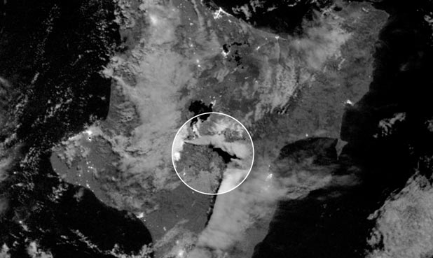
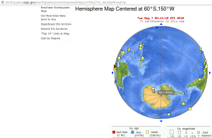
NASA: Tongariro ash plume seen in moonlight satellite image + Tongariro still steaming, but activity levels low. Context of Mount Tongariro’s explosive revival, after 115 years – Antarctic Plate quake escalation:
Antarctic circle of earthquake effects - USGS 2012-08-08

Antarctic circle of earthquake effects – USGS 2012-08-08


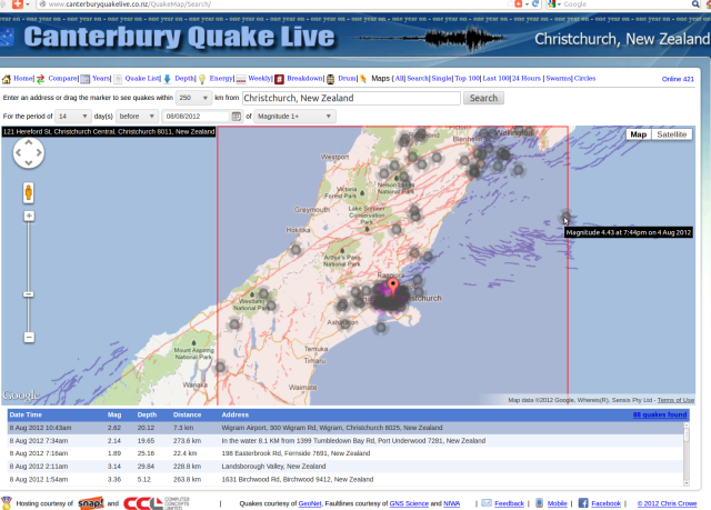
14 days' magnitude 1+ quakes converged on northern Alpine Fault - Crowe.co.nz 2012-08-08

14 days’ magnitude 1+ quakes converged on northern Alpine Fault – Crowe.co.nz 2012-08-08

An amateur, observational view, with civil defence needs in mind: The obvious stresses, from the two magnitude 7.1 earthquakes south and north of the past two years, are building north and south of the northern end of the Alpine Fault – south of the Blenheim-Wellington line and east of Christchurch respectively. The torsion on this zone – pushed east in the north and west in the south is what creates both our earthquakes and our land. The greater ability for movement of the eastern North Island is what opens up deep crust in its wake, allowing volcanic vents like White Island, Tongariro, and the whole Taupo-Kermadec zone. The New Zealand reality, of its outstanding newness as an above-water dynamic mass. Kia kaha. Kia manawanui. Kia tupato. Ka kite ano. Kia ora.

25,000 sq km sea of pumice floats off New Zealand traced to 17-18 July event Another volcano in New Zealand waters could be active “GNS scientists think they have tracked down the source of a huge raft of pumice drifting towards New Zealand, to a volcano that may have errupted for the first time ever.”

Pompeii Supervolcano Could Mean Doomsday For Millions, And It’s Not The Only One “A caldera is [a] cauldron formed by land that has collapsed after a volcanic eruption.. Fortunately, it is extremely rare for these areas to erupt at their full capacity.. The real danger of a supervolcano is the ash, which — in large enough quantity — can collect in the atmosphere and block out the sun, causing severe global climate changes” huffingtonpost.com 08/08/2012

NZ recent Quakes - GNS 120512

NZ recent Quakes – GNS 120512

Now that is one ugly mess of subduction movement the length of Aotearoa!

Source: GeoNet.org.nz Recent New Zealand Earthquakes.

So what’s up?

A good way to keep aware – of anything these day – is Facebook. There you can read how last night I gave warning that today’s magnitude 5.5 and 3.9 quakes were on the way. To find out more, friend facebook.com/rik.tindall.

Looking forward to seeing you there 🙂

The North Island has risks even bigger than the South.

Kia kaha. Kia toa. Kia manawanui. Kia ora.

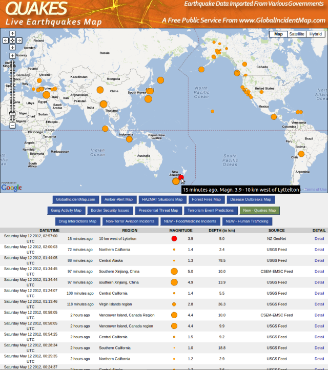
Tuatapere mag 5.5, Cashmere 3.9 - GIM 120512

Tuatapere mag 5.5, Cashmere 3.9 – GIM 120512


Source: quakes.globalincidentmap.com

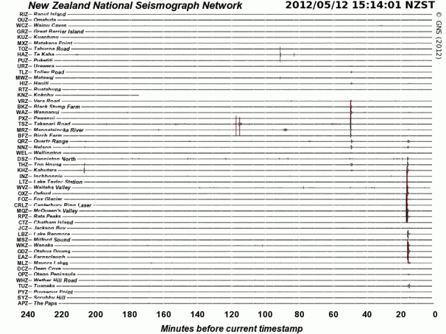
NZ deep south mag 5.5 quake - NSN 120512

NZ deep south mag 5.5 quake – NSN 120512


NZ Cashmere mag 3.9 quake - NSN 120512

NZ Cashmere mag 3.9 quake – NSN 120512

Source: geonet.org.nz/earthquake/drums

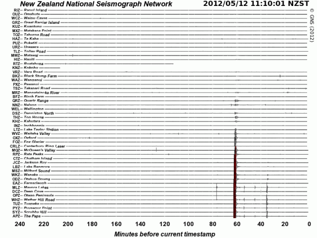
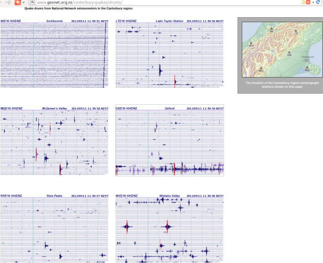
The give-away seismicity that enabled correct forecast of these magnitude 5.5 and ‘4’ approx events:

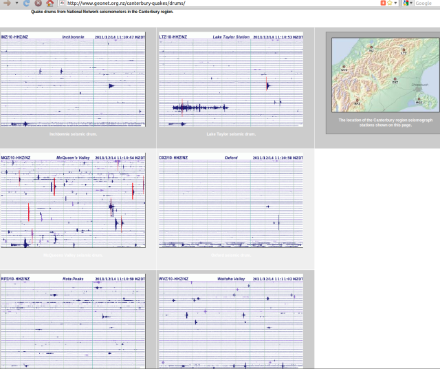
Mount Oxford jitters - GNS Canterbury Seismograph Drums 110512

Mount Oxford jitters – GNS Canterbury Seismograph Drums 110512


Source: geonet.org.nz/canterbury-quakes/drums/.
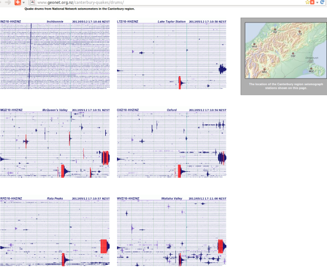
The magnitude 5.5 and 3.9 quakes as recorded in Canterbury:
Tuatapere mag 5.5, Cashmere 3.9 quakes - GNS Canterbury seismic Drums 120512

Tuatapere mag 5.5, Cashmere 3.9 quakes – GNS Canterbury seismic Drums 120512

And next there was the Tue, May 15 2012 1:27 pm Magnitude 4.5, Depth 11 km, 10 km north-east of Christchurch, confirming absolutely that correct indicators for upcoming Christchurch aftershocks have been discovered, in the September 4th 2010 earthquake wake.

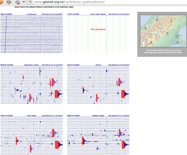
A week later, again via Facebook, a forecast “4 towards 5?” was spot-on-time: Sun, May 20 2012 5:06 pm Magnitude 4.8, Depth 8 km, 20 km east of Christchurch, following a 9:35am 4.1.

magnitude 4.8 quake off Southshore - GNS 200512

magnitude 4.8 quake off Southshore – GNS 200512


Christchurch magnitude 4.1, 4.8 quakes - GNS Canterbury seismograph drums 200512

Christchurch magnitude 4.1, 4.8 quakes – GNS Canterbury seismograph drums 200512

Picking up community debate, for better civic information and responses:

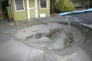
Sustainable Canterbury, Mauriroa Waitaha: 23 December 2011 earthquake aftermath #Parklands

Parklands liquefaction Hurst Place 130611 - Parklands Red-zone Action Group

Parklands liquefaction Hurst Place 130611 - Parklands Red-zone Action Group

More info: Search “December 23 quakes” stuff.co.nz

Here is the global seismic backdrop to earthquake series revival in Canterbury NZ. North-south, Alaska to Antarctica, warmed Earth crust is flexing. The tectonic pressure heaviest accumulated around the slow-moving Zealandia land mass, which is mostly submerged to Christchurch’s east and south, is increasingly expressing itself. Eventually, this mass too must move – with Pacific plate expansion, driving Alpine Fault rupture towards the south-west.

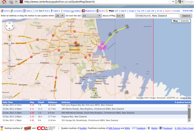
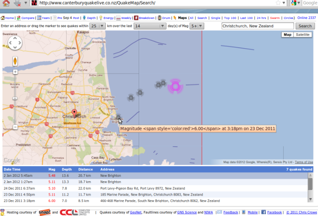
Here are the three largest offshore earthquake sites from 23 December, showing their alignment with a major south-west to north-east underground fracture fault that is the product of deep subduction trench activity to the north. Note also the coincidence of the 29-30 December aftershock upsurge, as on 23 December, with equivalent force events on the Kermadec trench.

23 Dec 2011 big quakes alignment - L-R: 6.0, 5.8, 5.3 - Crowe.co.nz 311211

23 Dec 2011 big quakes alignment - L-R: mag' 6.0, 5.8, 5.3 - Crowe.co.nz 311211

Base graphic source: canterburyquakelive.co.nz/QuakeMap/Search/

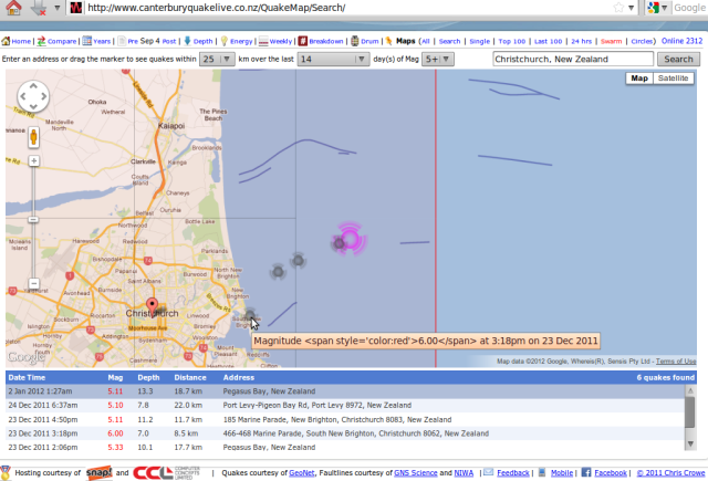
Update – the latest magnitude 5.1 quake 1.27am NZDT also confirms this fault alignment:

 020112 Pegasus Bay mag 5.1 quake, alignment to 23 Dec 6.0 etc - Crowe.co.nz

020112 Pegasus Bay mag 5.1 quake, alignment to 23 Dec 6.0 etc - Crowe.co.nz


According to Lack of aftershocks a good sign – expert diagram from The Press of 08/07/2011, we are now witnessing the direct extension of the Port Hills Fault. Will this eventually trigger something nearer to 7, on the newly-discovered offshore Kaiapoi Fault?
Christchurch faults - The Press 060711

Christchurch faults - The Press 060711

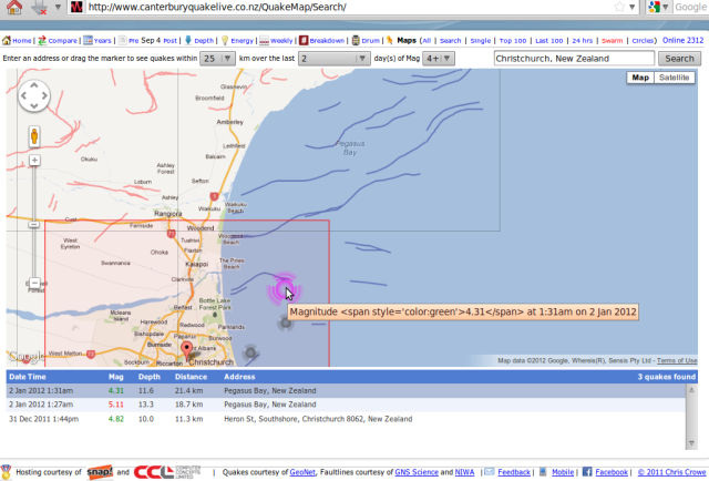
Theory confirmed – quakes have now reached Kaiapoi fault area … :
Pegasus Bay mag 5.1 quake, Kaiapoi 4.3 alignment - Crowe 020112

Pegasus Bay mag 5.1 quake, Kaiapoi 4.3 alignment - Crowe 020112


Update – the latest magnitude 5.4 quake 5:45am NZDT also confirms this fault alignment:
Pegasus Bay mag 5.4 quake - canterburyquakelive.co.nz 020112a

Pegasus Bay mag 5.4 quake - canterburyquakelive.co.nz 020112a

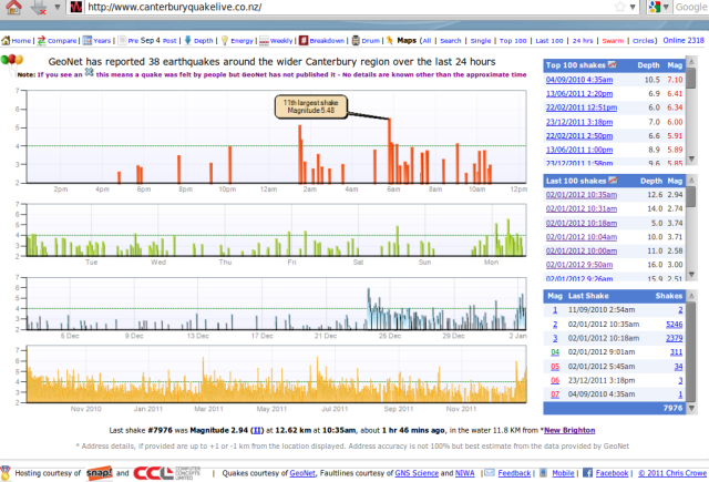
According to canterburyquakelive.co.nz and The Press Quake swarm rattles Christchurch, we just had “the 11th largest shake to hit the city” since 4 September 2010:

Pegasus Bay mag 5.4 quake history - Chris Crowe 020112c

Pegasus Bay mag 5.4 quake history - Chris Crowe 020112c

Note especially the increasing quake intensity at bottom right of these four charts.

Note: Shocks may be ‘last gasp’ of Feb 22 fault “this could be some residual activity from the eastern end of the February 22 fault that didn’t rupture all the way out there.. United States seismologist Kevin Furlong.. ‘what makes this a bit intriguing is that it has continued in such a systematic way for so long. I guess my arm-waving explanation is that the entire region was sufficiently stressed, and there were numerous fault segments, none of them particularly large, that were near failure conditions’ [! And?]” The Press 03/01/2012 + Shocks-could-trigger-exodus “those affected to maintain routines, communicate with friends and family, and seek help if needed” / GNS to give briefing on latest quakes + Earthquake woes set to intensify “Heading into 2012, many issues are set to intensify. Insurance wrangles, rising land prices and land zoning will be among contentious points as significant strides are expected to be made towards the region’s recovery. Of most concern is that about 3000 properties remain in limbo. The Canterbury Earthquake Recovery Authority has said the orange and white zones are ‘high priority’, and affected residents will be hoping for a belated Christmas present” 02/01/2012 + doubts over local science Aftershock may be one of biggest. More, refer to: [Canterbury Issues] #Chch leadership drought #NZ #CDEM

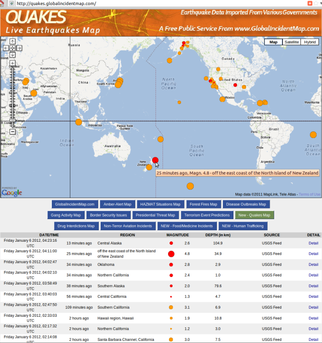
List from quakes.globalincidentmap.com (magnitude + km depth + data feed source):

Friday January 6 2012, 12:21:35 UTC South Island of New Zealand 4.5 9.9 USGS
Friday January 6 2012, 12:14:11 UTC Southern Alaska 2.9 101.1 USGS
Friday January 6 2012, 11:47:19 UTC Northern California 2.2 0.6 USGS
Friday January 6 2012, 11:29:43 UTC Northern California 1.5 2.9 USGS
Friday January 6 2012, 11:28:30 UTC Northern California 1.1 2.4 USGS
Friday January 6 2012, 11:24:40 UTC Southern Alaska 3.5 100.9 USGS
Friday January 6 2012, 10:49:33 UTC Northern California 2.6 0.2 USGS
Friday January 6 2012, 10:13:37 UTC Northern California 1.1 0.1 USGS
Friday January 6 2012, 09:04:04 UTC Island of Hawaii, Hawaii 2.0 1.5 USGS
Friday January 6 2012, 08:08:38 UTC off coast of Bio-Bio, Chile 5.0 15.2 USGS
Friday January 6 2012, 07:47:47 UTC Central California 1.2 8.0 USGS
Friday January 6 2012, 07:46:24 UTC Central California 1.3 0.0 USGS
Friday January 6 2012, 07:32:10 UTC Central California 1.1 8.1 USGS
Friday January 6 2012, 07:09:34 UTC Central California 1.2 8.1 USGS
Friday January 6 2012, 07:08:40 UTC Central California 2.1 6.6 USGS
Friday January 6 2012, 07:04:16 UTC South Island of New Zealand 4.7 11.3 USGS
Friday January 6 2012, 06:50:09 UTC Central California 3.3 7.3 USGS
Friday January 6 2012, 06:48:11 UTC Puerto Rico region 3.0 16.5 USGS
Friday January 6 2012, 06:37:20 UTC Mindoro, Philippines 4.8 169.8 USGS
Friday January 6 2012, 06:26:53 UTC Central California 2.8 6.5 USGS
Friday January 6 2012, 06:11:49 UTC northern Texas 2.0 4.9 USGS
Friday January 6 2012, 05:53:47 UTC Southern Alaska 2.9 13.2 USGS
Friday January 6 2012, 05:28:57 UTC Myanmar 4.4 54.1 USGS
Friday January 6 2012, 04:31:14 UTC New Ireland region, Papua New Guinea 4.8 80.4 USGS
[Update: pattern exactly as forecast – pix at bottom of page[1] – quake prediction service now temporarily suspended, while seeking a poll of support]

Friday January 6 2012, 04:23:16 UTC Central Alaska 2.6 104.9 USGS
Friday January 6 2012, 04:11:00 UTC off east coast North Island New Zealand 4.8 34.9 USGS
Friday January 6 2012, 04:02:47 UTC Oklahoma 2.8 2.9 USGS
Friday January 6 2012, 04:02:10 UTC Northern California 2.4 1.0 USGS
Friday January 6 2012, 03:58:49 UTC Southern Alaska 2.0 79.6 USGS
Friday January 6 2012, 02:47:50 UTC Southern California 3.1 6.9 USGS
Friday January 6 2012, 02:33:03 UTC Hawaii region, Hawaii 1.9 10.8 USGS
Friday January 6 2012, 02:14:08 UTC Santa Barbara Channel, California 3.0 7.5 USGS
Friday January 6 2012, 02:06:53 UTC Turkey-Syria-Iraq border region 4.3 4.5 USGS
Friday January 6 2012, 01:20:57 UTC South Island of New Zealand 4.5 8.4 USGS
Friday January 6 2012, 00:38:48 UTC southern Mid-Atlantic Ridge 5.1 10.0 USGS

Friday January 6 2012, 00:16:53 UTC eastern Turkey 4.6 10.0 USGS
Thursday January 5 2012, 23:52:48 UTC Virgin Islands region 3.0 35.0 USGS
Thursday January 5 2012, 23:28:44 UTC near east coast Honshu, Japan 4.9 22.0 USGS
Thursday January 5 2012, 23:14:48 UTC Kepulauan Batu, Indonesia 5.1 38.3 USGS
Thursday January 5 2012, 22:22:42 UTC offshore Baja California Sur, Mexico 4.3 15.0 USGS
Thursday January 5 2012, 22:02:40 UTC Dominican Republic 4.6 60.7 USGS
Thursday January 5 2012, 22:02:38 UTC Dominican Republic 4.0 20.0 USGS
Thursday January 5 2012, 21:55:22 UTC Pacific-Antarctic Ridge 5.2 15.9 USGS
Thursday January 5 2012, 20:55:47 UTC near east coast Honshu, Japan 5.0 45.5 USGS
Thursday January 5 2012, 20:30:53 UTC Central Alaska 2.2 123.7 USGS
Thursday January 5 2012, 19:49:43 UTC Utah 2.8 9.6 USGS
Thursday January 5 2012, 19:42:23 UTC Central Alaska 2.1 88.7 USGS
Thursday January 5 2012, 18:58:23 UTC Fox Islands, Aleutian Islands, Alaska 4.0 39.8 USGS
Thursday January 5 2012, 17:28:28 UTC Central California 2.0 10.5 USGS
Thursday January 5 2012, 17:18:14 UTC Central California 1.1 3.9 USGS
Thursday January 5 2012, 16:53:39 UTC southern Iran 5.0 32.5 USGS
Thursday January 5 2012, 16:47:05 UTC near the east coast of Honshu, Japan 5.1 20.1 USGS
Thursday January 5 2012, 16:29:28 UTC Southern Alaska 2.2 27.3 USGS
Thursday January 5 2012, 16:26:27 UTC Tonga 4.5 197.6 USGS
Thursday January 5 2012, 16:25:40 UTC Northern California 2.0 8.9 USGS
Thursday January 5 2012, 16:07:09 UTC Southern California 2.0 7.7 USGS
Thursday January 5 2012, 16:00:49 UTC Alabama 2.9 7.6 USGS
Thursday January 5 2012, 16:00:48 UTC Alabama 2.9 1.0 USGS
Thursday January 5 2012, 15:24:13 UTC Puerto Rico region 3.9 112.0 USGS
Thursday January 5 2012, 14:05:04 UTC Central California 1.9 4.8 USGS
Thursday January 5 2012, 13:52:29 UTC Central California 2.1 9.8 USGS
Thursday January 5 2012, 13:51:54 UTC Island of Hawaii, Hawaii 2.7 6.6 USGS
Thursday January 5 2012, 13:45:23 UTC Alaska Peninsula 2.6 5.6 USGS
Thursday January 5 2012, 13:05:24 UTC Southern Alaska 2.0 37.7 USGS
Thursday January 5 2012, 12:51:35 UTC Southern Alaska 2.1 109.2 USGS
Thursday January 5 2012, 12:27:57 UTC Central Alaska 2.1 0.0 USGS
Thursday January 5 2012, 12:16:40 UTC Central California 3.0 10.4 USGS
Thursday January 5 2012, 10:15:12 UTC western Montana 2.4 11.7 USGS
Thursday January 5 2012, 10:15:12 UTC western Montana 1.7 5.6 USGS
Thursday January 5 2012, 09:35:29 UTC Dominican Republic 5.3 10.0 USGS
Thursday January 5 2012, 09:15:34 UTC offshore Guatemala 4.4 66.1 USGS
Thursday January 5 2012, 09:14:41 UTC Southeastern Alaska 2.6 2.0 USGS
Thursday January 5 2012, 09:00:03 UTC Southern California 2.6 2.1 USGS
Thursday January 5 2012, 08:51:29 UTC Central California 1.1 4.0 USGS
Thursday January 5 2012, 07:56:37 UTC Crete, Greece 4.5 41.1 USGS
Thursday January 5 2012, 07:34:00 UTC Southern Alaska 2.0 16.8 USGS
Thursday January 5 2012, 07:20:10 UTC southern Idaho 3.4 4.9 USGS
Thursday January 5 2012, 06:10:18 UTC Northern California 2.1 18.4 USGS
Thursday January 5 2012, 06:10:18 UTC Northern California 1.9 18.3 USGS
Thursday January 5 2012, 06:03:06 UTC Northern California 1.0 1.2 USGS
Thursday January 5 2012, 04:48:32 UTC Kenai Peninsula, Alaska 2.3 78.7 USGS
Thursday January 5 2012, 04:37:43 UTC Central Alaska 2.2 107.0 USGS
Thursday January 5 2012, 04:08:04 UTC Southern Alaska 2.0 23.9 USGS
Thursday January 5 2012, 02:08:59 UTC Central California 2.1 8.0 USGS
Thursday January 5 2012, 01:19:55 UTC Sulawesi, Indonesia 4.8 97.0 USGS

[Update: 4.8 quake strikes Christchurch “tremor struck at 8.28am and was 15 kilometres deep and 10km east of the city.. centred in Pegasus Bay, where numerous quakes have been centred since the swarm on December 23” stuff.co.nz 08:45 05/01/2012 NZDT – expect more 5+ Antarctic plate rim quakes south of NZ, then rising Chch aftershocks again soon after those..]
Wednesday January 4 2012, 20:10:19 UTC Central Alaska 2.2 0.0 USGS
Wednesday January 4 2012, 19:53:36 UTC Santa Cruz Islands 5.1 43.2 USGS
Wednesday January 4 2012, 18:57:00 UTC Santa Cruz Islands 5.2 101.6 USGS

Wednesday January 4 2012, 18:30:58 UTC Southern California 2.1 6.7 USGS
Wednesday January 4 2012, 18:29:43 UTC Southern California 1.2 30.8 USGS
Wednesday January 4 2012, 18:25:42 UTC Southern California 2.2 5.5 USGS
Wednesday January 4 2012, 18:18:45 UTC Central California 1.4 9.9 USGS
Wednesday January 4 2012, 18:14:24 UTC near the north coast of New Guinea, Papua New Guinea 4.7 122.5 USGS
Wednesday January 4 2012, 18:04:30 UTC Tonga region 4.9 20.5 USGS [ = the current quake energy focus.. south-west Pacific, moving east]

Wednesday January 4 2012, 17:24:31 UTC Southern Alaska 3.8 135.6 USGS
Wednesday January 4 2012, 16:51:43 UTC Pakistan 4.8 10.0 USGS
Wednesday January 4 2012, 16:31:29 UTC southwestern Kashmir 4.2 40.5 USGS
Wednesday January 4 2012, 16:25:37 UTC Southeastern Alaska 4.3 17.8 USGS
Wednesday January 4 2012, 16:25:36 UTC British Columbia, Canada 4.3 7.0 USGS
Wednesday January 4 2012, 16:25:35 UTC Canada 4.4 92.0 Natural Resources Canada
Wednesday January 4 2012, 16:25:35 UTC Canada 4.2 90.0 Natural Resources Canada
Wednesday January 4 2012, 16:15:32 UTC Southern Yukon Territory, Canada 2.0 17.8 USGS
Wednesday January 4 2012, 16:12:53 UTC Central Alaska 2.5 36.4 USGS
Wednesday January 4 2012, 16:01:46 UTC Washington 2.4 0.8 USGS
Wednesday January 4 2012, 15:35:51 UTC Kepulauan Barat Daya, Indonesia 5.2 149.9 USGS
Wednesday January 4 2012, 15:12:26 UTC Puerto Rico region 2.6 15.3 USGS
Wednesday January 4 2012, 14:30:16 UTC Central Alaska 2.0 95.1 USGS
Wednesday January 4 2012, 14:30:16 UTC Central Alaska 2.1 95.3 USGS
Wednesday January 4 2012, 14:21:21 UTC Izu Islands, Japan region 4.7 407.3 USGS
Wednesday January 4 2012, 13:56:17 UTC Puerto Rico 2.1 6.0 USGS
Wednesday January 4 2012, 13:45:06 UTC Central Alaska 2.4 13.0 USG
Wednesday January 4 2012, 13:08:11 UTC southwestern Siberia, Russia 4.7 10.0 USG
Wednesday January 4 2012, 12:43:30 UTC Northern California 2.1 2.6 USGS
Wednesday January 4 2012, 11:49:40 UTC Mona Passage, Puerto Rico 2.7 11.0 USGS
Wednesday January 4 2012, 11:07:20 UTC Central Alaska 2.4 12.7 USGS
Wednesday January 4 2012, 11:07:21 UTC Central Alaska 2.1 18.1 USGS
Wednesday January 4 2012, 10:57:32 UTC Northern California 1.9 1.9 USGS
Wednesday January 4 2012, 09:22:13 UTC Virgin Islands region 3.1 126.0 USGS [ = the current quake energy focus.. south-Central Pacific, moving south]
Wednesday January 4 2012, 08:41:37 UTC Puerto Rico region 3.4 75.9 USGS
Wednesday January 4 2012, 06:59:57 UTC Taiwan 4.4 11.5 USGS
Wednesday January 4 2012, 06:48:06 UTC Central Alaska 2.0 13.5 USGS
Wednesday January 4 2012, 06:47:21 UTC Baja California, Mexico 2.8 6.5 USGS
Wednesday January 4 2012, 06:28:33 UTC Southern California 2.2 13.9 USGS
Wednesday January 4 2012, 06:25:12 UTC Northern California 2.8 3.0 USGS
Wednesday January 4 2012, 06:22:34 UTC Northern California 1.2 3.1 USGS
Wednesday January 4 2012, 06:16:54 UTC Southern Alaska 2.0 23.1 USGS
Wednesday January 4 2012, 05:57:45 UTC Southeastern Alaska 2.3 0.1 USGS
Wednesday January 4 2012, 04:47:35 UTC Vanuatu 5.2 233.1 USGS
Wednesday January 4 2012, 04:41:06 UTC south of Sumba, Indonesia 4.8 26.9 USGS
Wednesday January 4 2012, 04:32:18 UTC Island of Hawaii, Hawaii 1.7 10.4 USGS
Wednesday January 4 2012, 04:20:49 UTC Unimak Island region, Alaska 2.7 41.9 USGS
Wednesday January 4 2012, 03:58:51 UTC Southern California 1.4 8.9 USGS
Wednesday January 4 2012, 03:53:40 UTC Southern California 2.0 10.9 USGS
Wednesday January 4 2012, 03:38:56 UTC Southern California 1.6 7.4 USGS
Wednesday January 4 2012, 02:35:12 UTC Island of Hawaii, Hawaii 1.7 6.2 USGS
Wednesday January 4 2012, 02:07:52 UTC Ryukyu Islands, Japan 4.9 21.9 USGS
Wednesday January 4 2012, 01:49:13 UTC Bonin Islands, Japan region 4.8 9.3 USGS [ = the current quake energy focus.. north-Central Pacific, moving south]

Wednesday January 4 2012, 00:26:01 UTC Southern Alaska 3.9 136.8 USGS
Tuesday January 3 2012, 23:35:57 UTC Island of Hawaii, Hawaii 2.4 6.9 USGS
Tuesday January 3 2012, 22:03:16 UTC British Columbia, Canada 2.1 0.0 USGS
Tuesday January 3 2012, 21:50:27 UTC offshore Bio-Bio, Chile 4.6 32.6 USGS
Tuesday January 3 2012, 21:32:37 UTC Puerto Rico region 3.2 51.5 USGS
Tuesday January 3 2012, 21:12:48 UTC San Francisco Bay area, California 2.2 10.6 USGS
Tuesday January 3 2012, 21:00:26 UTC Island of Hawaii, Hawaii 1.8 6.2 USGS
Tuesday January 3 2012, 18:29:13 UTC Puerto Rico region 2.5 11.0 USGS
Tuesday January 3 2012, 18:11:00 UTC Unimak Island region, Alaska 2.4 41.5 USGS
Tuesday January 3 2012, 17:55:33 UTC Nevada 2.3 13.7 USGS
Tuesday January 3 2012, 15:40:02 UTC Guam region 5.2 35.5 USGS
Tuesday January 3 2012, 14:18:56 UTC Channel Islands region, California 4.1 18.4 USGS
Tuesday January 3 2012, 13:32:54 UTC Hawaii region, Hawaii 3.7 44.5 USGS
Tuesday January 3 2012, 13:32:56 UTC Hawaii region, Hawaii 3.4 15.5 USGS
Tuesday January 3 2012, 13:02:39 UTC Central Alaska 1.8 0.4 USGS
Tuesday January 3 2012, 12:20:17 UTC Kuril Islands 4.9 43.5 USGS
Tuesday January 3 2012, 10:56:57 UTC Oklahoma 3.2 4.9 USGS
Tuesday January 3 2012, 08:41:37 UTC Fox Islands, Aleutian Islands, Alaska 4.5 99.8 USGS
Tuesday January 3 2012, 07:57:31 UTC Central Alaska 1.5 7.4 USGS
Tuesday January 3 2012, 07:40:01 UTC southern Xinjiang, China 4.5 44.2 USGS
Tuesday January 3 2012, 07:20:49 UTC Central Alaska 2.1 94.0 USGS
Tuesday January 3 2012, 07:13:31 UTC Central Alaska 1.5 115.8 USGS
Tuesday January 3 2012, 07:10:54 UTC Southern Alaska 2.4 24.5 USGS
Tuesday January 3 2012, 07:10:44 UTC Northern California 2.4 2.8 USGS
Tuesday January 3 2012, 06:09:48 UTC Fox Islands, Aleutian Islands, Alaska 2.8 24.9 USGS
Tuesday January 3 2012, 05:46:52 UTC south of Alaska 3.0 29.5 USGS [= the current quake energy focus.. North Pacific]
Tuesday January 3 2012, 04:02:00 UTC Central Alaska 2.4 74.8 USGS
Tuesday January 3 2012, 03:29:06 UTC San Pedro Channel, California 2.2 0.1 USGS
Tuesday January 3 2012, 03:16:33 UTC Greater Los Angeles area, California 2.0 13.0 USGS
Tuesday January 3 2012, 03:06:24 UTC Alaska Peninsula 3.8 46.9 USGS
Tuesday January 3 2012, 02:58:51 UTC Central Alaska 2.6 16.0 USGS
Tuesday January 3 2012, 02:11:33 UTC Southern California 2.0 2.4 USGS
Tuesday January 3 2012, 01:30:57 UTC Baja California, Mexico 2.9 12.2 USGS
Tuesday January 3 2012, 00:42:13 UTC British Columbia, Canada 2.1 0.0 USGS
Tuesday January 3 2012, 00:20:29 UTC Central Alaska 2.0 14.7 USGS
Monday January 2 2012, 22:04:57 UTC Nevada 1.9 4.8 USGS
Monday January 2 2012, 22:02:09 UTC Island of Hawaii, Hawaii 1.8 6.3 USGS
Monday January 2 2012, 21:56:58 UTC Nevada 1.8 0.1 USGS
Monday January 2 2012, 21:31:11 UTC Gulf of Alaska 3.3 10.9 USGS
Monday January 2 2012, 21:15:46 UTC Island of Hawaii, Hawaii 2.4 4.9 USGS
Monday January 2 2012, 19:14:10 UTC Kodiak Island region, Alaska 2.3 13.2 USGS
Monday January 2 2012, 18:15:53 UTC Central Alaska 2.0 9.9 USGS
Monday January 2 2012, 17:08:50 UTC Northern California 1.0 2.2 USGS
Monday January 2 2012, 16:41:26 UTC Northern California 1.2 2.0 USGS
Monday January 2 2012, 16:30:31 UTC Northern California 2.1 6.3 USGS
Monday January 2 2012, 16:06:23 UTC Fox Islands, Aleutian Islands, Alaska 3.7 17.6 USGS
Monday January 2 2012, 16:04:21 UTC Northern California 1.7 2.4 USGS
Monday January 2 2012, 15:55:27 UTC Northern California 1.5 2.1 USGS
Monday January 2 2012, 15:54:43 UTC Northern California 3.0 2.4 USGS
Monday January 2 2012, 15:23:25 UTC Southern Alaska 2.6 44.7 USGS
Monday January 2 2012, 15:23:25 UTC Southern Alaska 2.7 40.3 USGS
Monday January 2 2012, 14:23:52 UTC Southern Alaska 2.5 107.0 USGS
Monday January 2 2012, 14:19:01 UTC Alaska Peninsula 1.8 1.3 USGS
Monday January 2 2012, 14:14:56 UTC Central Alaska 2.1 10.4 USGS
Monday January 2 2012, 13:21:23 UTC Central Alaska 3.2 15.0 USGS
Monday January 2 2012, 13:20:34 UTC Puerto Rico region 2.6 4.2 USGS
Monday January 2 2012, 13:10:29 UTC Virgin Islands region 3.3 12.0 USGS
Monday January 2 2012, 13:07:08 UTC New Ireland region, Papua New Guinea 4.7 10.0 USGS
Monday January 2 2012, 12:58:42 UTC Central California 1.8 3.8 USGS
Monday January 2 2012, 12:50:08 UTC Central Alaska 2.0 130.1 USGS
Monday January 2 2012, 12:45:21 UTC Central Alaska 1.7 5.4 USGS
Monday January 2 2012, 12:25:35 UTC Island of Hawaii, Hawaii 3.0 0.0 USGS
Monday January 2 2012, 11:53:26 UTC Virgin Islands region 3.0 52.0 USGS
Monday January 2 2012, 11:18:32 UTC Central California 1.4 5.5 USGS
Monday January 2 2012, 11:18:05 UTC Central California 2.1 4.0 USGS
Monday January 2 2012, 11:11:24 UTC Central Alaska 2.4 0.0 USGS
Monday January 2 2012, 11:08:46 UTC Southern Alaska 2.3 4.8 USGS
Monday January 2 2012, 10:42:01 UTC Virgin Islands region 2.9 61.0 USGS
Monday January 2 2012, 10:40:33 UTC Virgin Islands region 2.7 58.0 USGS
Monday January 2 2012, 10:32:28 UTC Unimak Island region, Alaska 2.1 9.3 USGS
Monday January 2 2012, 09:49:49 UTC Central Alaska 2.0 116.4 USGS
Monday January 2 2012, 09:39:57 UTC northern Mid-Atlantic Ridge 4.8 10.0 USGS
Monday January 2 2012, 08:55:12 UTC Rat Islands, Aleutian Islands, Alaska 4.9 89.6 USGS
Monday January 2 2012, 08:34:27 UTC Kenai Peninsula, Alaska 2.4 46.6 USGS
Monday January 2 2012, 08:27:59 UTC Kenai Peninsula, Alaska 1.8 93.7 USGS
Monday January 2 2012, 07:02:46 UTC offshore Northern California 2.8 16.3 USGS
Monday January 2 2012, 06:53:27 UTC Central California 2.2 4.0 USGS
Monday January 2 2012, 06:38:31 UTC Southern Alaska 2.7 71.5 USGS
Monday January 2 2012, 06:36:29 UTC Gulf of Santa Catalina, California 2.0 0.1 USGS
Monday January 2 2012, 05:59:14 UTC South Island of New Zealand 4.5 13.2 USGS
Monday January 2 2012, 05:24:23 UTC Northern California 1.9 2.3 USGS
Monday January 2 2012, 05:09:15 UTC Northern California 1.1 2.5 USGS
Monday January 2 2012, 04:58:38 UTC Central Alaska 3.0 152.8 USGS
Monday January 2 2012, 04:04:11 UTC Southern Alaska 2.4 90.7
Monday January 2 2012, 03:57:59 UTC Northern California 1.1 3.1 USGS
Monday January 2 2012, 03:25:31 UTC Northern California 1.5 2.7 USGS
Monday January 2 2012, 03:09:12 UTC Southern California 2.4 18.6 USGS
Monday January 2 2012, 01:30:32 UTC Southern Alaska 2.2 35.4 USGS
Monday January 2 2012, 01:29:05 UTC Alaska Peninsula 2.0 25.3 USGS
Monday January 2 2012, 00:52:56 UTC Central Alaska 2.0 13.6 USGS
Monday January 2 2012, 00:52:49 UTC Northern California 2.0 2.5 USGS
Monday January 2 2012, 00:16:09 UTC Southern California 1.6 2.8 USGS
Sunday January 1 2012, 23:57:21 UTC Romania 4.2 33.2 USGS
Sunday January 1 2012, 23:56:22 UTC Southern California 1.8 5.6 USGS
Sunday January 1 2012, 23:26:01 UTC Southern California 2.1 1.2 USGS
Sunday January 1 2012, 22:59:13 UTC Vanuatu 5.1 32.2 USGS
Sunday January 1 2012, 21:27:00 UTC Southern Alaska 2.3 14.7 USGS
Sunday January 1 2012, 21:07:28 UTC Halmahera, Indonesia 5.0 87.1 USGS
Sunday January 1 2012, 20:06:21 UTC Northern California 2.0 1.8 USGS
Sunday January 1 2012, 19:32:51 UTC Bougainville region, Papua New Guinea 4.9 146.0 USGS
Sunday January 1 2012, 19:14:43 UTC Central Alaska 2.5 123.1 USGS
Sunday January 1 2012, 18:16:17 UTC Utah 2.2 0.2 USGS
Sunday January 1 2012, 18:09:01 UTC northern Sumatra, Indonesia 5.3 1.0 USGS
Sunday January 1 2012, 17:22:08 UTC Central California 2.3 1.3 USGS
Sunday January 1 2012, 16:45:05 UTC South Island of New Zealand 5.0 19.4 USGS
Sunday January 1 2012, 15:57:06 UTC Puerto Rico region 2.6 4.1 USGS
Sunday January 1 2012, 15:47:36 UTC Northern California 2.2 3.6 USGS
Sunday January 1 2012, 15:45:52 UTC Northern California 1.6 5.4 USGS
Sunday January 1 2012, 15:44:15 UTC south of the Mariana Islands 5.1 22.2 USGS
Sunday January 1 2012, 14:59:30 UTC San Francisco Bay area, California 2.5 1.6 USGS
Sunday January 1 2012, 14:52:49 UTC Northern California 2.2 3.4 USGS
Sunday January 1 2012, 14:48:42 UTC south of Panama 4.4 10.1 USGS
Sunday January 1 2012, 14:28:08 UTC Central Alaska 2.2 0.0 USGS
Sunday January 1 2012, 13:32:20 UTC Southern Alaska 2.6 198.9 USG
Sunday January 1 2012, 13:32:20 UTC Southern Alaska 2.5 200.2 USGS
Sunday January 1 2012, 12:27:56 UTC South Island of New Zealand 5.0 13.8 USGS
Sunday January 1 2012, 11:59:05 UTC south of the Kermadec Islands 4.9 42.9 USGS

Sunday January 1 2012, 11:49:06 UTC Central California 2.0 9.2 USGS
Sunday January 1 2012, 11:30:20 UTC Central Alaska 2.3 0.0 USGS
Sunday January 1 2012, 09:29:48 UTC Southern California 2.1 8.6 USGS
Sunday January 1 2012, 09:29:43 UTC off east coast Honshu, Japan 4.7 10.0 USGS
Sunday January 1 2012, 09:29:48 UTC off east coast Honshu, Japan 4.6 45.7 USGS
Sunday January 1 2012, 09:29:48 UTC Southern California 2.1 8.6 USGS
Sunday January 1 2012, 08:53:49 UTC Southern California 2.2 7.4 USGS
Sunday January 1 2012, 08:31:26 UTC near the east coast of Honshu, Japan 4.5 43.1 USGS
Sunday January 1 2012, 08:29:44 UTC Island of Hawaii, Hawaii 1.7 32.5 USGS
Sunday January 1 2012, 07:40:27 UTC offshore Guatemala 4.3 71.5 USGS
Sunday January 1 2012, 06:52:17 UTC Mona Passage, Puerto Rico 3.0 17.0 USGS
Sunday January 1 2012, 05:48:29 UTC Central Alaska 2.3 22.7 USGS
Sunday January 1 2012, 05:27:54 UTC Izu Islands, Japan region 6.8 348.5 USGS
Sunday January 1 2012, 05:19:39 UTC Andaman Islands, India region 4.6 31.8 USGS
Sunday January 1 2012, 04:56:41 UTC Pacific-Antarctic Ridge 5.1 10.0 USGS
Sunday January 1 2012, 04:39:21 UTC Southern Alaska 2.0 24.0 USGS
Sunday January 1 2012, 02:40:36 UTC northern Colombia 4.0 158.1 USGS
Sunday January 1 2012, 02:35:19 UTC Tripura, India region 4.6 15.2 USGS
Sunday January 1 2012, 01:02:45 UTC Central Alaska 2.5 0.0 USGS
Sunday January 1 2012, 00:50:09 UTC Santa Cruz Islands 5.2 77.6 USGS
Sunday January 1 2012, 00:43:05 UTC Southern Alaska 2.1 142.2 USGS
Sunday January 1 2012, 00:37:25 UTC Central Alaska 3.0 63.3 USGS
Sunday January 1 2012, 00:30:06 UTC south of the Mariana Islands 5.1 18.1 USGS
Saturday December 31 2011, 22:49:33 UTC Bonin Islands, Japan region 4.8 694.1 USGS
Saturday December 31 2011, 20:35:03 UTC Southern Alaska 2.4 97.0 USGS
Saturday December 31 2011, 20:05:01 UTC Youngstown-Akron urban area, Ohio 4.0 5.0 USGS
Saturday December 31 2011, 20:04:58 UTC Youngstown-Akron urban area, Ohio 4.0 2.2 USGS
Saturday December 31 2011, 19:39:50 UTC Central Alaska 3.2 23.5 USGS
Saturday December 31 2011, 19:14:45 UTC Baja California, Mexico 3.2 12.7 USGS
Saturday December 31 2011, 17:10:33 UTC off coast Costa Rica 4.6 51.8 USGS
Saturday December 31 2011, 16:36:05 UTC Nevada 2.0 21.3 USGS
Saturday December 31 2011, 16:32:49 UTC Northern California 1.6 2.2 USGS
Saturday December 31 2011, 16:15:08 UTC Salta, Argentina 5.3 13.1 USGS
Saturday December 31 2011, 15:12:15 UTC Northern California 1.1 0.7 USGS
Saturday December 31 2011, 15:05:16 UTC Northern California 2.2 0.9 USGS
Saturday December 31 2011, 14:53:14 UTC Northern California 1.8 2.6 USGS
Saturday December 31 2011, 14:40:56 UTC Central Alaska 2.2 83.9 USGS
Saturday December 31 2011, 14:33:19 UTC Central Alaska 2.2 111.5 USGS
Saturday December 31 2011, 14:31:02 UTC Central Alaska 1.6 4.5 USGS
Saturday December 31 2011, 14:13:17 UTC Southern Alaska 1.9 15.0 USGS
Saturday December 31 2011, 13:42:16 UTC Northern California 1.3 2.7 USGS
Saturday December 31 2011, 13:20:42 UTC Central California 1.9 5.0 USGS
Saturday December 31 2011, 13:16:27 UTC Southern California 1.5 0.1 USGS
Saturday December 31 2011, 12:47:11 UTC Northern California 1.9 2.6 USGS
Saturday December 31 2011, 11:43:57 UTC Northern California 1.4 2.7 USGS
Saturday December 31 2011, 10:47:55 UTC Nevada 2.0 6.5 USGS
Saturday December 31 2011, 10:23:16 UTC Fox Islands, Aleutian Islands, Alaska 3.0 29.0 USGS
Saturday December 31 2011, 10:20:56 UTC Island of Hawaii, Hawaii 2.9 37.7 USGS
Saturday December 31 2011, 09:55:00 UTC offshore Guatemala 4.3 60.5 USGS
Saturday December 31 2011, 09:13:17 UTC Turkey-Iran-Iraq border region 4.4 18.7 USGS
Saturday December 31 2011, 08:56:54 UTC Northern California 2.1 2.3 USGS
Saturday December 31 2011, 08:07:18 UTC Oklahoma 3.5 5.0 USGS
Saturday December 31 2011, 07:43:59 UTC Nevada 1.7 0.2 USGS
Saturday December 31 2011, 07:06:00 UTC Island of Hawaii, Hawaii 1.9 32.8 USGS
Saturday December 31 2011, 06:14:42 UTC Kepulauan Sula, Indonesia 4.9 42.1 USGS
Saturday December 31 2011, 05:39:52 UTC Pakistan 4.9 31.3 USGS
Saturday December 31 2011, 05:02:07 UTC Central California 2.4 4.6 USGS
Saturday December 31 2011, 04:49:59 UTC Northern California 1.4 1.6 USGS
Saturday December 31 2011, 04:30:26 UTC Northern California 1.5 2.3 USGS
Saturday December 31 2011, 04:25:37 UTC Northern California 2.0 2.9 USGS
Saturday December 31 2011, 04:05:44 UTC Kepulauan Sula, Indonesia 4.8 19.8 USGS
Saturday December 31 2011, 03:57:03 UTC Banda Sea 4.6 73.1 USGS
Saturday December 31 2011, 03:54:11 UTC Oklahoma 2.1 5.0 USGS
Saturday December 31 2011, 03:10:08 UTC Island of Hawaii, Hawaii 2.7 7.7 USGS
Saturday December 31 2011, 01:30:22 UTC Kenai Peninsula, Alaska 2.3 47.8 USGS
Saturday December 31 2011, 01:29:36 UTC Kenai Peninsula, Alaska 2.4 39.8 USGS
Saturday December 31 2011, 01:20:30 UTC Puerto Rico region 2.7 28.4 USGS
Saturday December 31 2011, 01:07:27 UTC Southern California 2.2 3.7 USGS
Saturday December 31 2011, 00:53:56 UTC Colombia 4.7 106.0 USGS
Saturday December 31 2011, 00:44:46 UTC South Island of New Zealand 5.3 10.1 USGS
Saturday December 31 2011, 00:24:26 UTC New Guinea, Papua New Guinea 4.9 37.5 USGS

Saturday December 31 2011, 00:08:27 UTC Southern Alaska 2.0 59.9 USGS
Friday December 30 2011, 23:11:07 UTC near east coast Honshu, Japan 4.8 20.9 USGS
Friday December 30 2011, 23:06:13 UTC northern Alaska 2.2 4.6 USGS
Friday December 30 2011, 22:58:27 UTC Southern Alaska 2.0 61.9 USGS
Friday December 30 2011, 22:55:32 UTC Northern California 2.1 29.4 USGS
Friday December 30 2011, 22:35:40 UTC Northern California 1.9 1.8 USGS
Friday December 30 2011, 22:30:20 UTC south of Kermadec Islands 4.7 41.1 USGS
Friday December 30 2011, 22:25:41 UTC Northern California 2.1 30.1 USGS
Friday December 30 2011, 22:15:49 UTC Northern California 1.6 33.7 USGS
Friday December 30 2011, 22:04:07 UTC Northern California 1.4 31.2 USGS
Friday December 30 2011, 21:43:19 UTC south of the Kermadec Islands 5.2 34.6 USGS
Friday December 30 2011, 20:42:46 UTC Greater Los Angeles area, California 1.6 16.0 USGS
Friday December 30 2011, 20:03:47 UTC San Francisco Bay area, California 1.5 0.7 USGS
Friday December 30 2011, 18:49:59 UTC Vanuatu region 4.9 26.2 USGS
Friday December 30 2011, 17:29:54 UTC south of Kermadec Islands 5.0 9.8 USGS

Friday December 30 2011, 17:29:33 UTC Central California 2.3 7.8 USGS
Friday December 30 2011, 17:24:29 UTC Alaska Peninsula 2.9 200.4 USGS
Friday December 30 2011, 17:13:57 UTC Central Alaska 2.9 141.4 USGS
Friday December 30 2011, 17:07:21 UTC Izu Islands, Japan region 5.2 397.9 USGS
Friday December 30 2011, 16:34:34 UTC South Sandwich Islands region 5.2 106.2 USGS

Friday December 30 2011, 16:32:44 UTC Baja California, Mexico 2.7 10.0 USGS
Friday December 30 2011, 16:31:18 UTC Southern California 2.0 12.6 USGS
Friday December 30 2011, 16:19:06 UTC Central California 2.2 4.4 USGS
Friday December 30 2011, 16:09:32 UTC western Montana 3.2 6.2 USGS
Friday December 30 2011, 15:55:54 UTC Baja California, Mexico 3.0 21.1 USGS
Friday December 30 2011, 15:55:54 UTC Baja California, Mexico 2.8 10.0 USGS
Friday December 30 2011, 15:50:12 UTC Baja California, Mexico 3.1 10.0 USGS
Friday December 30 2011, 15:48:23 UTC Virgin Islands region 3.4 72.4 USGS
Friday December 30 2011, 15:34:29 UTC Baja California, Mexico 4.3 10.0 USGS
Friday December 30 2011, 14:18:52 UTC Nevada 2.4 11.7 USGS
31 Dec 2011 1:44pm NZDT Heron St, Southshore, Christchurch 8062, New Zealand 4.82 10.0 Crowe
Friday December 30 2011, 13:17:58 UTC Guam region 4.6 19.1 USGS
Friday December 30 2011, 12:59:52 UTC Baja California, Mexico 2.9 20.9 USGS
Friday December 30 2011, 12:35:19 UTC Rat Islands, Aleutian Islands, Alaska 4.5 30.2 USGS
Friday December 30 2011, 12:23:17 UTC near east coast Kamchatka Peninsula, Russia 4.4 55.9 USGS
Friday December 30 2011, 12:17:44 UTC Pacific-Antarctic Ridge 4.6 10.0 USGS
Friday December 30 2011, 12:10:06 UTC Utah 1.6 0.3 USGS
Friday December 30 2011, 12:10:06 UTC Northern California 2.3 2.7 USGS
Friday December 30 2011, 12:06:18 UTC Island of Hawaii, Hawaii 1.7 6.4 USGS
Friday December 30 2011, 11:53:54 UTC Southern Alaska 3.0 62.2 USGS
Friday December 30 2011, 10:49:31 UTC Canada 2.6 46.0 Natural Resources Canada
Friday December 30 2011, 10:49:30 UTC Maine 2.0 7.7 USGS
Friday December 30 2011, 10:35:30 UTC Hawaii region, Hawaii 2.6 39.4 USGS
Friday December 30 2011, 09:36:29 UTC south of the Fiji Islands 4.7 221.2 USGS
Friday December 30 2011, 09:34:50 UTC near east coast Honshu, Japan 4.6 68.0 USGS
Friday December 30 2011, 09:22:16 UTC near coast central Peru 5.1 51.3 USGS
Friday December 30 2011, 08:51:58 UTC southern Sumatra, Indonesia 5.5 60.8 USGS
Friday December 30 2011, 08:46:42 UTC New Britain region, Papua New Guinea 5.0 53.5 USGS

Friday December 30 2011, 08:42:23 UTC Southern Yukon Territory, Canada 2.1 13.0 USGS
Friday December 30 2011, 08:11:29 UTC Long Valley area, California 1.4 3.1 USGS
Friday December 30 2011, 08:05:45 UTC Rat Islands, Aleutian Islands, Alaska 4.7 62.9 USGS
Friday December 30 2011, 08:03:43 UTC Canada 2.5 84.0 Natural Resources Canada
Friday December 30 2011, 07:41:28 UTC Canada 2.5 23.0 Natural Resources Canada
Friday December 30 2011, 07:13:02 UTC Ecuador 4.6 126.4 USGS
Friday December 30 2011, 06:26:05 UTC Canada 3.2 25.0 Natural Resources Canada
Friday December 30 2011, 06:00:07 UTC Greater Los Angeles area, California 1.4 16.7 USGS
Friday December 30 2011, 05:35:07 UTC San Francisco Bay area, California 1.9 5.8 USGS
Friday December 30 2011, 05:30:52 UTC Central California 1.7 4.7 USGS
Friday December 30 2011, 05:25:22 UTC Southern California 2.1 6.2 USGS
Friday December 30 2011, 04:59:52 UTC Hokkaido, Japan region 4.4 67.0 USGS
2011/12/30 03:46:15 FIJI REGION 4.4 513.6 USGS
Friday December 30 2011, 02:46:42 UTC Southern California 2.0 6.9 USGS
Friday December 30 2011, 02:29:53 UTC Southern California 1.8 10.6 USGS
Friday December 30 2011, 02:18:50 UTC Central California 3.0 9.3 USGS
Friday December 30 2011, 01:45:02 UTC Halmahera, Indonesia 4.8 87.3 USGS
Friday December 30 2011, 00:35:47 UTC eastern Turkey 4.3 4.9 USGS
Thursday December 29 2011, 22:56:01 UTC Central California 2.3 6.7 USGS
Thursday December 29 2011, 22:54:11 UTC Southern California 2.4 18.8 USGS
Thursday December 29 2011, 22:25:50 UTC Bougainville region, Papua New Guinea 5.3 505.0 USGS
Thursday December 29 2011, 20:34:59 UTC offshore Chiapas, Mexico 4.6 102.0 USGS
Thursday December 29 2011, 20:05:50 UTC Vanuatu 5.3 40.9 USGS
Thursday December 29 2011, 19:19:54 UTC Baja California, Mexico 2.8 22.4 USGS
Thursday December 29 2011, 18:28:18 UTC Fox Islands, Aleutian Islands, Alaska 4.4 25.6 USGS
Thursday December 29 2011, 18:17:33 UTC Central California 1.7 1.8 USGS
Thursday December 29 2011, 17:15:20 UTC Central California 2.0 4.9 USGS
30 Dec 2011 4:45am NZDT 351 Kainga Rd, Brooklands, Christchurch 8083, New Zealand 4.37 13.0 Crowe
Thursday December 29 2011, 16:31:53 UTC Central Alaska 2.5 21.8 USGS
Thursday December 29 2011, 15:06:31 UTC southeastern Missouri 2.8 7.8 USGS
Thursday December 29 2011, 13:58:55 UTC south of the Kermadec Islands 4.6 248.8 USGS
Thursday December 29 2011, 13:45:41 UTC near the coast of central Peru 4.8 77.5 USGS

Thursday December 29 2011, 12:54:09 UTC Oregon 1.6 3.4 USGS
Thursday December 29 2011, 12:53:04 UTC Oregon 1.9 9.6 USGS
Thursday December 29 2011, 11:58:29 UTC northern Colombia 4.3 147.3 USGS
Thursday December 29 2011, 11:48:10 UTC western Texas 2.5 4.9 USGS
29 Dec 2011 10:48pm NZDT 165E Rocking Horse Rd, Southshore, Christchurch 8062, New Zealand 4.32 12.1 Crowe
Thursday December 29 2011, 10:40:06 UTC Puerto Rico region 2.1 19.0 USGS
Thursday December 29 2011, 09:03:36 UTC western Montana 2.2 12.3 USGS
Thursday December 29 2011, 08:58:03 UTC Puerto Rico region 2.7 29.2 USGS
Thursday December 29 2011, 08:08:42 UTC Central California 2.1 6.1 USGS
Thursday December 29 2011, 07:51:04 UTC Northern California 2.2 6.1 USGS
Thursday December 29 2011, 07:48:17 UTC Northern California 2.1 0.3 USGS
Thursday December 29 2011, 07:25:10 UTC Southern Alaska 2.0 4.8 USGS
Thursday December 29 2011, 07:17:00 UTC Central Alaska 2.0 3.6 USGS
Thursday December 29 2011, 07:13:46 UTC Central Alaska 1.7 0.0 USGS
Thursday December 29 2011, 06:46:38 UTC Utah 1.5 6.9 USGS
Thursday December 29 2011, 06:44:46 UTC Utah 1.6 8.6 USGS
Thursday December 29 2011, 05:40:21 UTC Canada 2.2 93.0 Natural Resources Canada
Thursday December 29 2011, 05:19:58 UTC Guatemala 4.6 10.2 USGS
Thursday December 29 2011, 05:06:41 UTC Kodiak Island region, Alaska 3.6 58.2 USGS
Thursday December 29 2011, 04:41:05 UTC Fox Islands, Aleutian Islands, Alaska 2.9 4.2 USGS
Thursday December 29 2011, 04:18:38 UTC Southern Alaska 2.4 20.5 USGS
Thursday December 29 2011, 04:09:15 UTC Northern California 2.4 1.5 USGS
Thursday December 29 2011, 03:32:46 UTC southern Peru 4.6 197.3 USGS
Thursday December 29 2011, 01:12:03 UTC Southern California 2.5 16.7 USGS
Thursday December 29 2011, 00:49:47 UTC Northern California 2.4 2.6 USGS
Thursday December 29 2011, 00:30:56 UTC Pacific-Antarctic Ridge 5.5 16.9 USGS
Wednesday December 28 2011, 23:39:22 UTC Central Alaska 1.0 0.3 USGS
Wednesday December 28 2011, 23:21:03 UTC Central Alaska 2.0 31.1 USGS
Wednesday December 28 2011, 23:05:37 UTC Nevada 1.7 25.8 USGS
Wednesday December 28 2011, 22:47:13 UTC Central Alaska 2.0 1.9 USGS
Wednesday December 28 2011, 22:11:47 UTC British Columbia, Canada 2.4 0.0 USGS
Wednesday December 28 2011, 21:56:32 UTC Alaska Peninsula 2.2 1.3 USGS
Wednesday December 28 2011, 21:55:43 UTC Tonga 5.1 238.9 USGS
Wednesday December 28 2011, 21:45:53 UTC Oaxaca, Mexico 4.4 64.3 USGS
Wednesday December 28 2011, 21:03:33 UTC Southern California 1.4 17.3 USGS
Wednesday December 28 2011, 20:45:33 UTC San Francisco Bay area, California 1.5 0.1 USGS
Wednesday December 28 2011, 20:32:31 UTC South Sandwich Islands region 5.4 31.0 USGS
Wednesday December 28 2011, 18:42:02 UTC Puerto Rico region 2.5 72.2 USGS
Wednesday December 28 2011, 18:16:04 UTC Kenai Peninsula, Alaska 2.4 33.4 USGS
Wednesday December 28 2011, 18:14:34 UTC Southern California 2.1 4.0 USGS
Wednesday December 28 2011, 17:57:28 UTC Greater Los Angeles area, California 2.2 5.1 USGS
Wednesday December 28 2011, 17:50:12 UTC Southern Alaska 2.6 105.4 USGS
Wednesday December 28 2011, 17:33:55 UTC Halmahera, Indonesia 5.4 159.7 USGS
Wednesday December 28 2011, 16:47:30 UTC Greater Los Angeles area, California 1.9 5.7 USGS
Wednesday December 28 2011, 16:27:39 UTC Mindanao, Philippines 4.6 87.6 USGS
Wednesday December 28 2011, 16:12:22 UTC Canada 2.7 35.0 Natural Resources Canada
Wednesday December 28 2011, 15:49:28 UTC northern Alaska 3.0 11.1 USGS
Wednesday December 28 2011, 15:25:42 UTC southwestern Siberia, Russia 4.6 15.5 USGS
Wednesday December 28 2011, 15:20:42 UTC San Francisco Bay area, California 1.9 7.0 USGS
Wednesday December 28 2011, 15:19:57 UTC Island of Hawaii, Hawaii 1.8 6.3 USGS
Wednesday December 28 2011, 14:53:36 UTC Kodiak Island region, Alaska 2.8 11.7 USGS
Wednesday December 28 2011, 14:23:50 UTC southwest of Sumatra, Indonesia 4.7 17.9 USGS
Wednesday December 28 2011, 14:00:35 UTC Baja California, Mexico 2.1 9.8 USGS
Wednesday December 28 2011, 13:54:34 UTC southwestern Siberia, Russia 4.6 10.0 USGS
Wednesday December 28 2011, 13:13:03 UTC Puerto Rico region 2.8 101.5 USGS
Wednesday December 28 2011, 12:45:11 UTC Fox Islands, Aleutian Islands, Alaska 2.2 77.9 USGS
Wednesday December 28 2011, 11:43:41 UTC Atacama, Chile 4.9 41.9 USGS
Wednesday December 28 2011, 11:05:10 UTC New Mexico 2.5 5.0 USGS
Wednesday December 28 2011, 10:45:41 UTC Canada 2.6 32.0 Natural Resources Canada
Wednesday December 28 2011, 10:35:37 UTC New Britain region, Papua New Guinea 4.4 35.0 USGS
Wednesday December 28 2011, 10:07:05 UTC Puerto Rico region 3.0 17.3 USGS
Wednesday December 28 2011, 09:18:32 UTC Kuril Islands 4.7 62.0 USGS
Wednesday December 28 2011, 08:28:35 UTC Virgin Islands region 2.5 25.6 USGS
Wednesday December 28 2011, 06:59:14 UTC Southern California 2.9 8.5 USGS
Wednesday December 28 2011, 06:38:59 UTC Fiji region 5.2 613.7 USGS

List follows on from NZ Kermadec quakes on page; extract:
Friday December 23 2011, 17:37:30 UTC South Island of New Zealand 5.0 7.6 USGS
Friday December 23 2011, 10:52:06 UTC south of the Kermadec Islands 5.5 10.0 USGS
Friday December 23 2011, 03:50:12 UTC east coast South Island New Zealand 4.8 8.4 USGS
Friday December 23 2011, 02:18:02 UTC South Island of New Zealand 5.9 4.9 USGS
Friday December 23 2011, 01:41:37 UTC South Island of New Zealand 4.0 11.2 USGS
Friday December 23 2011, 01:30:24 UTC South Island of New Zealand 4.2 5.0 USGS
Friday December 23 2011, 01:06:25 UTC South Island of New Zealand 5.3 3.7 USGS

Wednesday December 21 2011, 13:37:14 UTC south of Kermadec Islands 5.5 10.0 USGS
= Magnitude 5.7, Thursday, December 22 2011 at 2:37 am (NZDT), 200 km south of L’Esperance Rock GeoNet

[1]

Pegasus Bay and East Cape NZ mag 5.0 quakes - GNS seismograph drums 060112e

Pegasus Bay and East Cape NZ mag 5.0 quakes - GNS seismograph drums 060112e


Pegasus Bay and East Cape NZ mag 5.0 quakes - GIM 060112

Pegasus Bay and East Cape NZ mag 5.0 quakes - GIM 060112

Southern Alpine tension is building up - NZ GNS recent quakes 051211

Southern Alpine tension is building up - NZ GNS recent quakes 051211

National Party government is bad for Aotearoa, as Earthquakes keep New Zealand shaking – “the biggest quake to hit the Marlborough region in 45 years” – The Dominion Post 05/12/2011.

Seismic disaster is what we see most of since National league commenced hostilities against local government and resident safeguards (building regulation) in Canterbury and throughout NZ, to privately benefit from disaster capitalism.

The Pacific plate is alive and flexing, with the Indo-Australian plate pushing harder against it – Zealandia continent is crushed south-west, and so we quake. Where will it end? [It never does]..

Ref. GeoNet Magnitude 5.7, Saturday, December 3 2011 at 7:19 pm (NZDT), 30 km east of Picton + Tonga Trench Tsunami threat from giant underwater volcanoes (2:19) 07 December 2011 TV1 BBC.

Picton, Cook Strait area mag 5.7 quake - USGS 051211

Picton, Cook Strait area mag 5.7 quake - USGS 051211

Source: earthquake.usgs.gov

Kermadecs mag 5.1 quake after Cook Strait 5.8 - GIM 051211

Kermadecs mag 5.1 quake after Cook Strait 5.8 - GIM 051211


Canterbury effect, seismometer drums - GNS 051211

Canterbury effect, seismometer drums - GNS 051211

Update: Western Australia mag 5.1 quake - the world is changing - GIM 061211

Update: Western Australia mag 5.1 quake - global tectonic events increasing - GIM 061211

Update: NZ quake week - GNS 061211

Update: NZ quake week - GNS 061211


Source: GeoNet December 2011 Archives by date

141211 Update: Kermadec Islands magnitude 4.7 quake and its Canterbury record (@ bottom left below)

Kermadecs mag 4.7 quake ripples NZ - GNS 141211

Kermadecs mag 4.7 quake ripples NZ - GNS 141211


Kermadecs mag 4.7 quake on Canterbury seismometer drums - GNS 141211

Kermadecs mag 4.7 quake on Canterbury seismometer drums - GNS 141211

List from quakes.globalincidentmap.com (magnitude + km depth + data feed source) – NZ day of risk rolls on:

Wednesday December 14 2011, 05:04:56 UTC eastern New Guinea region, Papua New Guinea 7.3 115.1 USGS
Wednesday December 14 2011, 04:57:20 UTC Central California 2.0 6.0 USGS
Wednesday December 14 2011, 04:09:22 UTC Central Alaska 2.3 250.0 USGS
Wednesday December 14 2011, 04:01:07 UTC eastern Honshu, Japan 4.9 50.6 USGS
Wednesday December 14 2011, 03:28:41 UTC Southern Alaska 1.8 25.3 USGS
Wednesday December 14 2011, 03:23:31 UTC Southern Alaska 1.3 50.0 USGS
Wednesday December 14 2011, 02:51:04 UTC Southern Alaska 4.0 43.0 USGS
Wednesday December 14 2011, 02:51:02 UTC Southern Alaska 3.7 6.5 USGS
Wednesday December 14 2011, 01:54:15 UTC Island of Hawaii, Hawaii 2.4 31.9 USGS
Wednesday December 14 2011, 01:27:43 UTC Central California 2.3 9.0 USGS
Wednesday December 14 2011, 00:48:23 UTC Puerto Rico region 3.2 38.0 USGS
Wednesday December 14 2011, 00:48:10 UTC Tonga 5.3 9.9 USGS
Wednesday December 14 2011, 00:38:38 UTC Island of Hawaii, Hawaii 1.9 1.5 USGS
Wednesday December 14 2011, 00:08:54 UTC Southern Alaska 1.3 29.3 USGS
Wednesday December 14 2011, 00:04:58 UTC Southern Alaska 2.2 99.1 USGS
Wednesday December 14 2011, 00:00:55 UTC Southern California 1.8 3.4 USGS
Tuesday December 13 2011, 23:36:22 UTC Arizona 3.1 8.2 USGS
Tuesday December 13 2011, 23:32:54 UTC Unimak Island region, Alaska 2.3 41.8 USGS
Tuesday December 13 2011, 23:19:26 UTC Central Alaska 2.0 9.4 USGS
Tuesday December 13 2011, 23:07:55 UTC north of the Virgin Islands 3.9 49.0 USGS
Tuesday December 13 2011, 22:06:39 UTC Central Alaska 2.6 22.8 USGS
Tuesday December 13 2011, 22:04:35 UTC Virgin Islands region 4.7 38.9 USGS
Tuesday December 13 2011, 21:09:34 UTC Kermadec Islands, New Zealand 4.7 184.6 USGS
Tuesday December 13 2011, 20:47:46 UTC Central Alaska 1.5 0.4 USGS
Tuesday December 13 2011, 20:47:46 UTC Central Alaska 1.9 0.0 USGS
Tuesday December 13 2011, 20:36:34 UTC Northern California 2.4 1.0 USGS
Tuesday December 13 2011, 20:36:34 UTC Northern California 2.3 3.2 USGS
Tuesday December 13 2011, 20:36:20 UTC south of Alaska 4.1 41.5 USGS
Tuesday December 13 2011, 19:52:36 UTC 2 hours ago Nevada 2.0 0.0 USGS
Tuesday December 13 2011, 19:21:39 UTC Island of Hawaii, Hawaii 1.9 3.9 USGS
Tuesday December 13 2011, 19:14:20 UTC Central Alaska 2.1 27.0 USGS
Tuesday December 13 2011, 17:51:07 UTC Kyushu, Japan 4.9 32.9 USGS
Tuesday December 13 2011, 17:47:09 UTC Central Alaska 2.3 0.5 USGS
Tuesday December 13 2011, 17:40:00 UTC Greater Los Angeles area, California 1.9 0.1 USGS
Tuesday December 13 2011, 17:38:47 UTC Nevada 2.1 0.2 USGS
Tuesday December 13 2011, 17:33:11 UTC Island of Hawaii, Hawaii 1.9 5.8 USGS
Tuesday December 13 2011, 17:06:22 UTC Puerto Rico region 2.7 1.7 USGS
Tuesday December 13 2011, 16:26:42 UTC Island of Hawaii, Hawaii 2.0 4.2 USGS
Tuesday December 13 2011, 16:17:48 UTC Nevada 2.1 1.6 USGS
Tuesday December 13 2011, 15:50:59 UTC Island of Hawaii, Hawaii 1.7 3.4 USGS
Tuesday December 13 2011, 15:50:22 UTC Northern California 2.5 3.7 USGS
Tuesday December 13 2011, 15:46:34 UTC Central Alaska 2.4 4.2 USGS
Tuesday December 13 2011, 15:21:35 UTC Central Alaska 2.2 113.6 USGS
Tuesday December 13 2011, 14:14:44 UTC Island of Hawaii, Hawaii 2.3 4.2 USGS
Tuesday December 13 2011, 14:11:13 UTC Island of Hawaii, Hawaii 2.7 4.6 USGS
Tuesday December 13 2011, 12:52:08 UTC Island of Hawaii, Hawaii 2.8 5.4 USGS
Tuesday December 13 2011, 12:22:42 UTC Central Alaska 2.0 0.0 USGS
Tuesday December 13 2011, 11:56:33 UTC Puerto Rico region 2.2 109.6 USGS
Tuesday December 13 2011, 11:41:37 UTC Puerto Rico region 3.1 28.0 USGS
Tuesday December 13 2011, 11:37:34 UTC Kenai Peninsula, Alaska 2.6 5.7 USGS
Tuesday December 13 2011, 11:25:05 UTC Southern Alaska 2.3 97.1 USGS
Tuesday December 13 2011, 11:06:11 UTC Puerto Rico region 3.2 18.4 USGS
Tuesday December 13 2011, 09:52:45 UTC Kodiak Island region, Alaska 2.4 0.7 USGS
Tuesday December 13 2011, 07:52:11 UTC Minahasa, Sulawesi, Indonesia 6.0 156.1 USGS
Tuesday December 13 2011, 07:28:54 UTC northern Mid-Atlantic Ridge 5.3 10.1 USGS
Tuesday December 13 2011, 07:28:11 UTC south of Panama 5.4 10.1 USGS

Tuesday December 13 2011, 06:49:47 UTC San Francisco Bay area, California 1.4 1.2 USGS
Tuesday December 13 2011, 05:55:53 UTC Nevada 1.2 9.5 USGS
Tuesday December 13 2011, 05:06:43 UTC Island of Hawaii, Hawaii 1.8 6.1 USGS
Tuesday December 13 2011, 04:41:04 UTC Maine 1.9 5.0 USGS
Tuesday December 13 2011, 04:41:03 UTC Maine 2.3 10.4 USGS
Tuesday December 13 2011, 04:41:02 UTC Canada 2.6 0.0 Natural Resources Canada
Tuesday December 13 2011, 04:39:38 UTC Southern Alaska 2.6 69.8 USGS
Tuesday December 13 2011, 04:27:16 UTC Dominican Republic region 3.0 66.3 USGS
Tuesday December 13 2011, 03:44:50 UTC western Montana 1.2 5.9 USGS
Tuesday December 13 2011, 03:21:25 UTC West Chile Rise 4.9 8.9 USGS
Tuesday December 13 2011, 01:52:18 UTC Olympic Peninsula, Washington 1.6 47.7 USGS
Tuesday December 13 2011, 01:24:59 UTC Nevada 2.4 2.3 USGS
Tuesday December 13 2011, 01:24:12 UTC Central California 2.3 7.0 USGS
Tuesday December 13 2011, 01:20:45 UTC Halmahera, Indonesia 5.3 110.2 USGS
Tuesday December 13 2011, 00:57:12 UTC off the east coast of Honshu, Japan 5.0 35.3 USGS

Tuesday December 13 2011, 00:52:54 UTC Central Alaska 1.9 0.0 USGS
Tuesday December 13 2011, 00:46:03 UTC Northern California 2.1 16.7 USGS
Monday December 12 2011, 23:34:12 UTC Canada 3.1 110.0 Natural Resources Canada
Monday December 12 2011, 23:15:03 UTC Southern California 2.2 7.5 USGS
Monday December 12 2011, 22:54:39 UTC Northern California 2.0 7.2 USGS
Monday 2011/12/12 20:23:59 LIBERTADOR O’HIGGINS, CHILE 4.8 40.8 USGS.gov
Monday 2011/12/12 16:19:44 OKLAHOMA 2.5 4.2 USGS.gov
Monday December 12 2011, 18:11:47 UTC Nevada 2.0 0.1 USGS
Monday December 12 2011, 15:43:38 UTC Minahasa, Sulawesi, Indonesia 4.9 147.2 USGS
Monday December 12 2011, 15:35:39 UTC Nevada 1.3 0.0 USGS
Monday December 12 2011, 15:02:20 UTC Hindu Kush region, Afghanistan 4.9 137.6 USGS
Monday December 12 2011, 15:02:05 UTC Santa Cruz Islands 4.9 230.0 USGS
Monday December 12 2011, 15:01:55 UTC Central Alaska 2.2 85.6 USGS
Monday December 12 2011, 14:44:38 UTC Southern Alaska 2.8 99.6 USGS
Monday December 12 2011, 12:49:47 UTC Northern California 2.5 2.2 USGS
Monday December 12 2011, 12:30:55 UTC Southern Alaska 2.4 15.6 USGS
Monday December 12 2011, 11:54:56 UTC Southern Alaska 2.0 29.1 USGS
Monday December 12 2011, 11:05:46 UTC Southern Alaska 2.4 40.7 USGS
Monday December 12 2011, 11:04:30 UTC Central California 2.1 21.7 USGS
Monday December 12 2011, 10:20:39 UTC Baja California, Mexico 3.1 11.8 USGS
Monday December 12 2011, 10:15:23 UTC Baja California, Mexico 2.6 11.5 USGS
Monday December 12 2011, 09:28:43 UTC Sakhalin, Russia 5.0 24.9 USGS
Monday December 12 2011, 08:31:33 UTC Southern California 2.4 18.7 USGS
Monday December 12 2011, 07:16:55 UTC Central Alaska 2.7 42.6 USGS
Monday December 12 2011, 07:09:24 UTC Southern Alaska 2.8 109.0 USGS
Monday December 12 2011, 06:52:34 UTC Baja California, Mexico 2.9 12.0 USGS
Monday December 12 2011, 06:47:48 UTC Virginia 2.1 2.8 USGS
Monday December 12 2011, 05:56:55 UTC Central Alaska 2.3 95.6 USGS
Monday December 12 2011, 05:53:29 UTC Island of Hawaii, Hawaii 1.9 6.0 USGS
Monday December 12 2011, 05:17:04 UTC Virgin Islands region 3.4 110.0 USGS
Monday December 12 2011, 04:46:21 UTC Maine 1.4 5.0 USGS
Monday December 12 2011, 04:15:53 UTC Northern California 2.1 5.6 USGS
Monday December 12 2011, 03:35:32 UTC Island of Hawaii, Hawaii 1.8 6.0 USGS
Monday December 12 2011, 02:54:44 UTC Central Alaska 2.2 27.2 USGS
Monday December 12 2011, 02:34:22 UTC near east coast Honshu, Japan 4.8 117.5 USGS
Monday December 12 2011, 02:24:10 UTC Central Alaska 2.5 15.3 USGS
Monday December 12 2011, 02:22:08 UTC Central Alaska 2.0 20.5 USGS
Monday December 12 2011, 02:09:38 UTC Southern California 2.7 7.4 USGS
Monday December 12 2011, 01:34:17 UTC Central California 2.1 3.9 USGS
Monday December 12 2011, 01:30:23 UTC San Francisco Bay area, California 1.8 6.3 USGS
Monday December 12 2011, 01:24:37 UTC Central Alaska 2.1 0.2 USGS
Monday December 12 2011, 01:20:56 UTC Central Alaska 2.3 6.6 USGS
Monday December 12 2011, 01:02:45 UTC Southern Alaska 2.8 115.1 USGS
Monday December 12 2011, 01:01:59 UTC western Montana 1.0 0.3 USGS
Monday December 12 2011, 00:24:37 UTC Greater Los Angeles area, California 2.6 6.4 USGS
Sunday December 11 2011, 22:21:14 UTC Alaska Peninsula 2.6 10.5 USGS
Sunday December 11 2011, 22:00:43 UTC British Columbia, Canada 2.3 0.0 USGS
Sunday December 11 2011, 21:56:02 UTC Bougainville region, Papua New Guinea 5.1 85.2 USGS
Sunday December 11 2011, 20:39:00 UTC Northern California 2.9 4.1 USGS
Sunday December 11 2011, 20:18:17 UTC Banda Sea 4.8 145.2 USGS
Sunday December 11 2011, 19:51:11 UTC near east coast Honshu, Japan 4.8 31.8 USGS
Sunday December 11 2011, 19:11:16 UTC Puerto Rico region 2.9 13.8 USGS
Sunday December 11 2011, 18:45:10 UTC Northern California 2.2 5.0 USGS
Sunday December 11 2011, 18:31:55 UTC Santa Monica Bay, California 2.0 19.8 USGS
Sunday December 11 2011, 13:58:17 UTC Nevada 1.2 4.1 USGS
Sunday December 11 2011, 13:34:16 UTC Nevada 2.8 4.9 USGS
Sunday December 11 2011, 13:33:26 UTC Nevada 2.1 16.3 USGS
Sunday December 11 2011, 12:38:58 UTC Gansu-Qinghai border region, China 4.6 20.9 USGS
Sunday December 11 2011, 10:35:28 UTC Southern California 2.1 7.3 USGS
Sunday December 11 2011, 09:54:55 UTC South Sandwich Islands region 6.2 115.5 USGS
Sunday December 11 2011, 09:40:10 UTC Molucca Sea 4.6 62.7 USGS
Sunday December 11 2011, 09:25:37 UTC Kenai Peninsula, Alaska 2.0 35.3 USGS
Sunday December 11 2011, 08:31:02 UTC Maule, Chile 4.9 81.5 USGS
Sunday December 11 2011, 07:40:19 UTC Central Alaska 2.6 4.6 USGS
Sunday December 11 2011, 06:34:19 UTC Java, Indonesia 4.3 35.0 USGS
Sunday December 11 2011, 05:35:59 UTC New Mexico 2.8 4.9 USGS
Sunday December 11 2011, 05:30:58 UTC south of the Fiji Islands 5.4 560.3 USGS
Sunday December 11 2011, 05:17:18 UTC northern Alaska 3.5 5.0 USGS
Sunday December 11 2011, 05:04:31 UTC off east coast Honshu, Japan 4.9 24.4 USGS
Sunday December 11 2011, 04:27:38 UTC Central Alaska 1.2 21.5 USGS
Sunday December 11 2011, 04:24:13 UTC Central Alaska 2.2 7.1 USGS
Sunday December 11 2011, 04:09:00 UTC Puerto Rico region 2.7 66.3 USGS
Sunday December 11 2011, 03:34:36 UTC offshore El Salvador 4.4 65.7 USGS
Sunday December 11 2011, 01:47:26 UTC Guerrero, Mexico 6.5 64.9 USGS
Sunday December 11 2011, 01:22:44 UTC Ryukyu Islands, Japan 5.8 27.9 USG
S
Sunday December 11 2011, 01:10:25 UTC Kepulauan Barat Daya, Indonesia 4.5 172.3 USGS
Sunday December 11 2011, 00:25:36 UTC Central California 2.4 10.6 USGS
Sunday December 11 2011, 00:25:06 UTC Island of Hawaii, Hawaii 2.3 7.7 USGS
Saturday December 10 2011, 23:48:57 UTC Puerto Rico region 2.0 10.6 USGS
Saturday December 10 2011, 23:03:12 UTC Island of Hawaii, Hawaii 3.5 25.7 USGS
Saturday December 10 2011, 22:17:02 UTC Northern California 2.3 1.6 USGS
Saturday December 10 2011, 22:06:25 UTC San Pedro Channel, California 2.0 31.9 USGS
Saturday December 10 2011, 21:51:40 UTC Baja California, Mexico 2.8 12.2 USGS
Saturday December 10 2011, 21:46:52 UTC Central California 2.1 5.6 USGS
Saturday December 10 2011, 21:12:36 UTC eastern New Guinea region, Papua New Guinea 5.0 74.6 USGS
Saturday December 10 2011, 19:57:13 UTC Northern California 2.1 6.8 USGS
Saturday December 10 2011, 19:05:02 UTC Kenai Peninsula, Alaska 3.3 134.2 USGS
Saturday December 10 2011, 19:01:33 UTC Southern Alaska 2.8 119.6 USGS
Saturday December 10 2011, 18:43:33 UTC Kenai Peninsula, Alaska 2.1 107.9 USGS
Saturday December 10 2011, 18:37:25 UTC south of the Fiji Islands 4.6 508.2 USGS
Saturday December 10 2011, 18:18:06 UTC Northern California 2.1 20.4 USGS
Saturday December 10 2011, 17:07:50 UTC Island of Hawaii, Hawaii 1.8 6.1 USGS
Saturday December 10 2011, 16:58:12 UTC Northern California 1.8 5.0 USGS
Saturday December 10 2011, 16:47:09 UTC Nevada 1.4 28.6 USGS
Saturday December 10 2011, 16:46:41 UTC Nevada 1.8 3.2 USGS
Saturday December 10 2011, 16:45:42 UTC Utah 2.9 0.5 USGS
Saturday December 10 2011, 16:13:52 UTC eastern Iran 4.7 25.6 USGS
Saturday December 10 2011, 14:55:25 UTC Southern Alaska 2.7 13.2 USGS
Saturday December 10 2011, 14:44:55 UTC Southern Alaska 2.6 116.6 USGS
Saturday December 10 2011, 14:29:16 UTC offshore Oaxaca, Mexico 4.3 22.4 USGS
Saturday December 10 2011, 14:28:19 UTC Kenai Peninsula, Alaska 2.0 47.2 USGS
Saturday December 10 2011, 14:04:15 UTC Northern California 2.1 5.5 USGS
Saturday December 10 2011, 12:58:41 UTC Northern California 2.5 3.9 USGS
Saturday December 10 2011, 12:08:44 UTC Crete, Greece 3.9 37.6 USGS
Saturday December 10 2011, 12:03:50 UTC Tennessee 1.0 5.0 USGS
Saturday December 10 2011, 11:22:43 UTC Southern Alaska 2.0 20.0 USGS
Saturday December 10 2011, 10:47:37 UTC Island of Hawaii, Hawaii 1.9 7.7 USGS
Saturday December 10 2011, 10:06:55 UTC Central Alaska 2.0 4.8 USGS
Saturday December 10 2011, 09:51:17 UTC Samar, Philippines 4.9 35.1 USGS
Saturday December 10 2011, 09:25:40 UTC Nevada 1.5 2.1 USGS
Saturday December 10 2011, 09:22:42 UTC south of the Fiji Islands 4.3 513.4 USGS
Saturday December 10 2011, 09:02:24 UTC Southern California 2.1 8.0 USGS
Saturday December 10 2011, 08:56:28 UTC Gulf of California 4.2 10.0 USGS
Saturday December 10 2011, 08:15:14 UTC Southern Alaska 2.3 12.3 USGS
Saturday December 10 2011, 08:10:07 UTC Southern Alaska 2.8 2.7 USGS
Saturday December 10 2011, 07:47:28 UTC Island of Hawaii, Hawaii 1.7 6.1 USGS
Saturday December 10 2011, 07:39:23 UTC Island of Hawaii, Hawaii 2.1 11.2 USGS
Saturday December 10 2011, 06:51:44 UTC offshore Northern California 2.2 21.3 USGS
Saturday December 10 2011, 06:26:33 UTC Southern Alaska 3.9 110.0 USGS
Saturday December 10 2011, 06:08:18 UTC near east coast Honshu, Japan 4.7 52.8 USGS
Saturday December 10 2011, 05:25:16 UTC Southern California 1.2 17.7 USGS
Saturday December 10 2011, 05:08:52 UTC Southern California 1.6 6.7 USGS
Saturday December 10 2011, 05:06:19 UTC Southern California 1.7 3.5 USGS
Saturday December 10 2011, 05:03:28 UTC Central Alaska 1.8 0.4 USGS
Saturday December 10 2011, 04:57:26 UTC Island of Hawaii, Hawaii 2.7 4.1 USGS
Saturday December 10 2011, 04:50:07 UTC Island of Hawaii, Hawaii 2.1 3.7 USGS
Saturday December 10 2011, 04:07:19 UTC Southern California 2.0 10.7 USGS
Saturday December 10 2011, 03:06:51 UTC Northern California 2.0 11.1 USGS
Saturday December 10 2011, 02:01:16 UTC Central Alaska 2.9 0.1 USGS
Saturday December 10 2011, 01:41:08 UTC Island of Hawaii, Hawaii 1.8 15.4 USGS
Saturday December 10 2011, 01:06:50 UTC Central Alaska 2.2 0.0 USGS
Saturday December 10 2011, 00:06:01 UTC Andreanof Aleutian Islands, Alaska 5.0 19.7 USGS
Friday December 9 2011, 23:28:42 UTC Southern Alaska 2.1 15.7 USGS
Friday December 9 2011, 22:15:54 UTC off the east coast of Honshu, Japan 4.8 33.4 USGS
Friday December 9 2011, 22:08:23 UTC Baja California, Mexico 2.0 6.7 USGS
Friday December 9 2011, 21:35:52 UTC Halmahera, Indonesia 4.8 75.0 USGS
Friday December 9 2011, 21:33:42 UTC Virgin Islands region 3.5 59.4 USGS
Friday December 9 2011, 21:22:39 UTC Canada 2.3 163.0 Natural Resources Canada
Friday December 9 2011, 19:54:27 UTC Kenai Peninsula, Alaska 2.1 219.0 USGS
Friday December 9 2011, 19:52:35 UTC western Montana 2.0 18.4 USGS
Friday December 9 2011, 19:42:56 UTC Sea of Okhotsk 5.5 380.2 USGS
Friday December 9 2011, 18:47:32 UTC western Texas 3.4 4.1 USG
Friday December 9 2011, 18:12:26 UTC Kepulauan Babar, Indonesia 4.4 176.6 USGS
Friday December 9 2011, 17:15:02 UTC Canada 2.1 67.0 Natural Resources Canada
Friday December 9 2011, 17:06:38 UTC Molucca Sea 4.9 41.4 USGS
Friday December 9 2011, 16:14:11 UTC Island of Hawaii, Hawaii 2.6 48.3 USGS
Friday December 9 2011, 15:17:38 UTC Central Alaska 2.1 0.1 USGS
Friday December 9 2011, 13:41:48 UTC Northern California 2.2 2.1 USGS
Friday December 9 2011, 13:26:11 UTC Channel Islands region, California 2.6 4.8 USGS
Friday December 9 2011, 12:54:11 UTC Central Alaska 2.0 14.9 USGS
Friday December 9 2011, 10:41:05 UTC Central Alaska 2.0 29.9 USGS
Friday December 9 2011, 10:13:54 UTC Southern Alaska 2.6 190.0 USGS
Friday December 9 2011, 10:02:37 UTC Mindoro, Philippines 4.6 132.9 USGS
Friday December 9 2011, 09:01:12 UTC Island of Hawaii, Hawaii 2.3 8.4 USGS
Friday December 9 2011, 08:14:00 UTC Crete, Greece 4.6 30.0 USGS
Friday December 9 2011, 07:43:30 UTC Alaska Peninsula 2.9 0.1 USGS
Friday December 9 2011, 06:15:52 UTC Southern Alaska 3.0 107.3 USGS
Friday December 9 2011, 05:26:32 UTC Baja California, Mexico 2.3 1.0 USGS
Friday December 9 2011, 05:16:00 UTC Northern California 2.1 9.0 USGS
Friday December 9 2011, 05:05:30 UTC Central California 2.0 5.3 USGS
Friday December 9 2011, 03:54:16 UTC Colorado 3.0 4.8 USGS
Friday December 9 2011, 03:23:34 UTC southern Iran 4.9 10.0 USGS
Friday December 9 2011, 03:21:06 UTC Washington 1.6 0.9 USGS
Friday December 9 2011, 03:04:13 UTC Northern California 2.4 1.9 USGS
Friday December 9 2011, 03:03:24 UTC Bali Sea 4.6 614.0 USGS
Friday December 9 2011, 02:35:20 UTC Central California 2.0 7.4 USGS
Friday December 9 2011, 01:44:14 UTC Central Alaska 1.5 26.7 USGS
Friday December 9 2011, 01:36:26 UTC Central Alaska 1.8 24.1 USGS
Friday December 9 2011, 01:25:44 UTC Central Alaska 4.5 33.0 USGS
Friday December 9 2011, 01:25:41 UTC Central Alaska 4.4 23.4 USGS
Friday December 9 2011, 00:52:06 UTC Central California 2.5 7.0 USGS
Thursday December 8 2011, 23:42:09 UTC Central Alaska 2.4 15.4 USGS
Thursday December 8 2011, 23:32:16 UTC Northern California 1.4 2.9 USGS
Thursday December 8 2011, 23:29:08 UTC Northern California 1.1 3.0 USGS
Thursday December 8 2011, 23:26:45 UTC Northern California 1.1 2.5 USGS
Thursday December 8 2011, 23:22:09 UTC Northern California 1.7 2.9 USGS
Thursday December 8 2011, 23:02:22 UTC Northern California 1.1 2.4 USGS
Thursday December 8 2011, 22:32:48 UTC Southern California 1.6 0.0 USGS
Thursday December 8 2011, 21:56:50 UTC Oregon 1.0 0.0 USGS
Thursday December 8 2011, 21:56:47 UTC Southern California 1.0 6.4 USGS
Thursday December 8 2011, 21:52:13 UTC Northern California 1.1 0.4 USGS
Thursday December 8 2011, 21:52:00 UTC Northern California 1.1 4.8 USGS
Thursday December 8 2011, 21:27:20 UTC Dominican Republic region 3.1 82.7 USGS
Thursday December 8 2011, 21:10:35 UTC Northern California 1.1 3.3 USGS
Thursday December 8 2011, 21:08:56 UTC Nevada 2.3 5.8 USGS
Thursday December 8 2011, 20:14:29 UTC Kenai Peninsula, Alaska 2.0 55.5 USGS
Thursday December 8 2011, 19:49:56 UTC Island of Hawaii, Hawaii 2.4 28.7 USGS
Thursday December 8 2011, 19:32:27 UTC Southern California 1.9 5.7 USGS
Thursday December 8 2011, 19:13:30 UTC Washington 1.1 0.2 USGS
Thursday December 8 2011, 18:14:32 UTC Central Alaska 2.8 9.1 USGS
Thursday December 8 2011, 17:57:11 UTC Island of Hawaii, Hawaii 1.8 6.1 USGS
Thursday December 8 2011, 17:53:37 UTC Gulf of Alaska 3.8 1.0 USGS
Thursday December 8 2011, 17:19:06 UTC Southern Alaska 2.0 23.9 USGS
Thursday December 8 2011, 17:16:14 UTC Northern California 3.4 24.9 USGS
Thursday December 8 2011, 16:12:38 UTC South Sandwich Islands region 5.2 153.7 USGS
Thursday December 8 2011, 15:56:07 UTC Puerto Rico region 2.5 25.4 USGS
Thursday December 8 2011, 15:34:38 UTC near east coast Honshu, Japan 4.9 54.1 USGS
Thursday December 8 2011, 15:31:01 UTC Luzon, Philippines 4.8 35.3 USGS
Thursday December 8 2011, 14:34:11 UTC offshore El Salvador 4.8 88.6 USGS
Thursday December 8 2011 16:12:38 UTC SOUTH SANDWICH ISLANDS REGION 5.2 153.7 USGS NEIC
Thursday December 8 2011, 14:03:03 UTC offshore El Salvador 4.6 89.6 USGS

Thursday December 8 2011, 13:24:29 UTC Bonin Islands, Japan region 4.8 10.1 USGS
Thursday December 8 2011, 11:45:50 UTC northern Alaska 3.5 35.2 USGS
Thursday December 8 2011, 10:56:16 UTC Northern California 1.2 3.2 USGS
Thursday December 8 2011, 10:19:14 UTC Northern California 1.6 3.4 USGS
Thursday December 8 2011, 10:12:19 UTC Northern California 1.2 3.3 USGS
Thursday December 8 2011, 10:06:04 UTC Northern California 1.2 3.3 USGS
Thursday December 8 2011, 10:05:23 UTC Northern California 1.2 3.7 USGS
Thursday December 8 2011, 10:01:03 UTC Northern California 1.0 3.6 USGS
Thursday December 8 2011, 09:59:41 UTC Northern California 1.0 3.9 USGS
Thursday December 8 2011, 09:59:15 UTC Northern California 2.4 3.6 USGS
Thursday December 8 2011, 09:57:54 UTC Northern California 3.3 3.5 USGS
Thursday December 8 2011, 08:54:46 UTC Azores Islands, Portugal 5.0 10.0 USGS
Thursday December 8 2011, 08:54:21 UTC Northern California 1.1 3.2 USGS
Thursday December 8 2011, 07:51:58 UTC St. Lawrence Valley region, Quebec, Canada 2.6 19.0 USGS
Thursday December 8 2011, 07:51:58 UTC Canada 3.1 12.3 Natural Resources Canada
Thursday December 8 2011, 07:41:06 UTC Island of Hawaii, Hawaii 2.0 7.4 USGS
Thursday December 8 2011, 07:21:13 UTC New York 1.9 8.8 USGS
Thursday December 8 2011, 06:39:32 UTC Northern California 1.9 26.3 USGS
Thursday December 8 2011, 06:33:47 UTC Greater Los Angeles area, California 2.7 16.2 USGS
Thursday December 8 2011, 06:08:26 UTC Baja California, Mexico 2.3 10.0 USGS
Thursday December 8 2011, 05:19:09 UTC off the coast of Northern California 4.0 2.6 USGS
Thursday December 8 2011, 05:13:58 UTC Sonora, Mexico 2.1 10.0 USGS
Thursday December 8 2011, 05:05:54 UTC Northern California 1.4 2.7 USGS
Thursday December 8 2011, 04:47:38 UTC Northern California 1.3 0.1 USGS
Thursday December 8 2011, 04:13:18 UTC Kuril Islands 4.6 72.5 USGS
Thursday December 8 2011, 03:21:09 UTC Northern California 1.0 2.2 USGS
Thursday December 8 2011, 03:17:49 UTC Bonin Islands, Japan region 5.0 35.0 USGS
Thursday December 8 2011, 02:28:30 UTC Andreanof Aleutian Islands, Alaska 3.0 25.6 USGS
Thursday December 8 2011, 01:13:22 UTC offshore Atacama, Chile 4.6 20.0 USGS
Thursday December 8 2011, 00:49:17 UTC Banda Sea 4.5 385.5 USGS
Thursday December 8 2011, 00:08:57 UTC Alaska Peninsula 3.2 107.3 USGS
Wednesday December 7 2011, 23:13:05 UTC Central Alaska 2.1 0.0 USGS
Wednesday December 7 2011, 23:07:09 UTC Andreanof Aleutian Islands, Alaska 3.2 6.4 USGS
Wednesday December 7 2011, 22:54:19 UTC northern Texas 2.7 5.0 USGS

Wednesday 2011/12/07 22:23:09 ATACAMA, CHILE 6.1 15.6
Wednesday 2011/12/07 20:50:25 ALASKA PENINSULA 2.9 4.6
Wednesday 2011/12/07 20:07:43 ANDREANOF ALEUTIAN ISLANDS, ALASKA 3.9 8.8
Wednesday 2011/12/07 19:19:25 KODIAK ISLAND REGION, ALASKA 2.7 22.2

Wednesday December 7 2011, 17:09:38 UTC Southern Alaska 2.0 81.9 USGS
Wednesday December 7 2011, 16:31:58 UTC Alaska Peninsula 2.2 89.4 USGS
Wednesday December 7 2011, 16:30:33 UTC Southern Alaska 3.3 51.4 USGS
Wednesday December 7 2011, 15:57:40 UTC northern Alaska 3.2 0.0 USGS
Wednesday December 7 2011, 15:11:31 UTC Andreanof Aleutian Islands, Alaska 3.6 142.1 USGS
Wednesday December 7 2011, 14:58:04 UTC Northern California 1.4 0.0 USGS
Wednesday December 7 2011, 14:22:28 UTC Island of Hawaii, Hawaii 2.2 7.2 USGS
Wednesday December 7 2011, 14:20:28 UTC Island of Hawaii, Hawaii 2.1 3.5 USGS
Wednesday December 7 2011, 13:38:28 UTC Kepulauan Sula, Indonesia 5.9 29.5 USGS
Wednesday December 7 2011, 12:55:40 UTC Northern California 2.0 7.3 USGS
Wednesday December 7 2011, 12:24:42 UTC Central California 2.0 6.4 USGS
Wednesday December 7 2011, 12:18:53 UTC Mona Passage, Dominican Republic 3.3 99.0 USGS
Wednesday December 7 2011, 12:03:17 UTC Greater Los Angeles area, California 1.5 5.0 USGS
Wednesday December 7 2011, 11:46:49 UTC Central California 1.4 7.0 USGS
Wednesday December 7 2011, 11:35:37 UTC Central California 2.2 6.8 USGS
Wednesday December 7 2011, 10:47:44 UTC Northern California 2.1 27.9 USGS
Wednesday December 7 2011, 10:27:54 UTC Northern California 2.1 0.1 USGS
Wednesday December 7 2011, 10:11:34 UTC Central California 1.3 7.1 USGS
Wednesday December 7 2011, 09:36:03 UTC Northern California 2.1 3.3 USGS
Wednesday December 7 2011, 09:33:06 UTC Central Alaska 2.8 99.8 USGS
Wednesday December 7 2011, 09:30:20 UTC Central Alaska 2.8 92.6 USGS
Wednesday December 7 2011, 08:36:07 UTC Gulf of Santa Catalina, California 1.6 0.1 USGS
Wednesday December 7 2011, 07:09:49 UTC Island of Hawaii, Hawaii 1.9 5.9 USGS
Wednesday December 7 2011, 05:34:34 UTC Kenai Peninsula, Alaska 2.0 172.7 USGS
Wednesday December 7 2011, 05:13:17 UTC Veracruz, Mexico 5.0 202.6 USGS
Wednesday December 7 2011, 04:26:38 UTC Island of Hawaii, Hawaii 2.1 5.6 USGS
Wednesday December 7 2011, 04:08:36 UTC Tonga 5.3 29.3 USGS
Wednesday December 7 2011, 03:43:22 UTC Island of Hawaii, Hawaii 3.4 6.0 USGS
Wednesday December 7 2011, 03:06:54 UTC Seattle-Tacoma urban area, Washington 2.2 23.5 USGS
Wednesday December 7 2011, 01:43:39 UTC northern Alaska 2.9 5.3 USGS
Tuesday December 6 2011, 22:25:36 UTC Kodiak Island region, Alaska 3.3 55.7 USGS
Tuesday December 6 2011, 21:56:25 UTC Central California 1.8 7.9 USGS
Tuesday December 6 2011, 21:52:49 UTC Mount St. Helens area, Washington 1.3 0.1 USGS
Tuesday December 6 2011, 21:27:27 UTC Kenai Peninsula, Alaska 3.1 33.3 USGS
Tuesday December 6 2011, 21:03:04 UTC Andreanof Aleutian Islands, Alaska 3.3 25.2 USGS
Tuesday December 6 2011, 20:52:57 UTC Central California 2.6 5.6 USGS
Tuesday December 6 2011, 20:45:40 UTC San Diego County urban area, California 1.4 0.0 USGS
Tuesday December 6 2011, 20:20:40 UTC Canada 2.9 209.0 Natural Resources Canada
Tuesday December 6 2011, 20:05:32 UTC Kenai Peninsula, Alaska 2.7 31.5 USGS
Tuesday December 6 2011, 19:31:47 UTC Leyte, Philippines 4.7 47.2 USGS
Tuesday December 6 2011, 19:28:09 UTC western Montana 1.8 8.5 USGS
Tuesday December 6 2011, 19:25:41 UTC Southern Alaska 3.1 111.6 USGS
Tuesday December 6 2011, 18:42:15 UTC Nevada 1.0 0.3 USGS
Tuesday December 6 2011, 18:39:13 UTC Tonga 5.0 110.8 USGS
Tuesday December 6 2011, 18:18:38 UTC North Atlantic Ocean 4.7 15.2 USGS
Tuesday December 6 2011, 18:16:43 UTC Kepulauan Sula, Indonesia 4.7 44.8 USGS
Tuesday December 6 2011, 17:16:23 UTC Island of Hawaii, Hawaii 2.3 36.3 USGS
Tuesday December 6 2011, 16:08:32 UTC Central California 2.4 5.3 USGS
Tuesday December 6 2011, 15:51:16 UTC Southern California 2.0 0.0 USGS
Tuesday December 6 2011, 15:46:27 UTC Turkey-Iraq border region 4.5 10.0 USGS
Tuesday December 6 2011, 15:04:21 UTC Halmahera, Indonesia 4.9 136.7 USGS
Tuesday December 6 2011, 14:46:45 UTC Southern California 2.2 5.1 USGS
Tuesday December 6 2011, 14:05:41 UTC Kenai Peninsula, Alaska 2.0 99.8 USGS
Tuesday December 6 2011, 13:50:00 UTC Northern California 1.7 2.2 USGS
Tuesday December 6 2011, 13:05:02 UTC Northern California 2.4 2.9 USGS
Tuesday December 6 2011, 12:58:18 UTC Canada 2.3 14.0 Natural Resources Canada
Tuesday December 6 2011, 12:50:26 UTC Southern California 2.4 5.5 USGS
Tuesday December 6 2011, 12:32:32 UTC Southern Alaska 3.1 9.8 USGS
Tuesday December 6 2011, 12:02:32 UTC Kenai Peninsula, Alaska 2.2 34.8 USGS
Tuesday December 6 2011, 11:55:52 UTC Northern California 2.1 2.2 USGS
Tuesday December 6 2011, 11:48:42 UTC Hawaii region, Hawaii 2.0 32.8 USGS
Tuesday December 6 2011, 11:02:37 UTC Southern California 1.8 0.2 USGS
Tuesday December 6 2011, 11:02:15 UTC Southern California 1.6 2.6 USGS
Tuesday December 6 2011, 11:00:12 UTC Southern California 1.5 2.7 USGS
Tuesday December 6 2011, 10:31:18 UTC Southern California 1.1 14.4 USGS
Tuesday December 6 2011, 10:26:54 UTC Southern California 1.7 11.6 USGS
Tuesday December 6 2011, 10:15:14 UTC Tonga 5.1 88.5 USGS
Tuesday December 6 2011, 09:44:03 UTC Island of Hawaii, Hawaii 1.7 2.9 USGS
Tuesday December 6 2011, 09:31:47 UTC Central California 2.0 5.1 USGS
Tuesday December 6 2011, 09:10:50 UTC Canada 3.4 103.0 Natural Resources Canada
Tuesday December 6 2011, 09:10:50 UTC Southern Yukon Territory, Canada 3.4 8.3 USGS
Tuesday December 6 2011, 07:55:52 UTC Central Alaska 2.3 91.7 USGS
Tuesday December 6 2011, 07:48:53 UTC Southern California 2.7 6.0 USGS
Tuesday December 6 2011, 06:51:31 UTC Island of Hawaii, Hawaii 1.8 5.3 USGS
Tuesday December 6 2011, 06:28:04 UTC Greater Los Angeles area, California 2.4 18.2 USGS
Tuesday December 6 2011, 06:04:28 UTC Mona Passage, Dominican Republic 3.6 125.5 USGS
Tuesday December 6 2011, 05:54:19 UTC Island of Hawaii, Hawaii 2.1 1.5 USGS
Tuesday December 6 2011, 03:59:32 UTC Greater Los Angeles area, California 1.8 19.0 USGS
Tuesday December 6 2011, 03:12:29 UTC San Francisco Bay, California 2.0 9.0 USGS
Tuesday December 6 2011, 02:56:01 UTC eastern Turkey 4.6 7.5 USGS
Tuesday December 6 2011, 02:22:52 UTC Southern Alaska 2.3 2.7 USGS
Tuesday December 6 2011, 02:08:17 UTC Northern California 1.0 2.4 USGS
Tuesday December 6 2011, 02:05:38 UTC Northern California 1.8 2.5 USGS
Tuesday December 6 2011, 02:02:30 UTC Nevada 1.0 5.8 USGS
Tuesday December 6 2011, 01:42:20 UTC Northern California 3.0 2.0 USGS
Tuesday December 6 2011, 01:26:03 UTC northern Alaska 2.4 9.9 USGS
Tuesday December 6 2011, 01:25:56 UTC Island of Hawaii, Hawaii 2.6 7.8 USGS
Tuesday December 6 2011, 01:24:28 UTC Nevada 1.1 8.5 USGS
Tuesday December 6 2011, 01:10:34 UTC Island of Hawaii, Hawaii 1.8 3.0 USGS
Tuesday December 6 2011, 00:48:45 UTC Island of Hawaii, Hawaii 1.9 4.7 USGS
Tuesday December 6 2011, 00:26:04 UTC Greater Los Angeles area, California 1.0 2.0 USGS
Tuesday December 6 2011, 00:15:23 UTC Southern Alaska 2.1 94.2 USGS
Monday December 5 2011, 22:24:44 UTC Baja California, Mexico 2.4 2.6 USGS
Monday December 5 2011, 20:18:14 UTC Southern Alaska 2.8 101.2 USGS
Monday December 5 2011, 19:28:35 UTC south coast Papua, Indonesia 5.7 10.8 USGS
Monday December 5 2011, 19:24:55 UTC Island of Hawaii, Hawaii 2.4 8.3 USGS
Monday December 5 2011, 19:10:03 UTC Western Australia 5.1 9.8 USGS
Monday December 5 2011, 18:29:48 UTC offshore Northern California 2.6 9.3 USGS
Monday December 5 2011, 18:05:14 UTC Southern California 1.9 11.7 USGS
Monday December 5 2011, 16:43:29 UTC Puerto Rico region 2.8 11.0 USGS
Monday December 5 2011, 16:10:33 UTC Tajikistan 4.6 115.9 USGS
Monday December 5 2011, 15:57:39 UTC off the coast of Jalisco, Mexico 4.1 10.0 USGS
Monday December 5 2011, 15:32:42 UTC central Mongolia 4.4 28.0 USGS
Monday December 5 2011, 14:39:07 UTC Olympic Peninsula, Washington 2.1 27.4 USGS
Monday December 5 2011, 14:39:06 UTC Canada 2.0 87.0 Natural Resources Canada
Monday December 5 2011, 14:34:43 UTC Southern California 2.3 9.2 USGS
Monday December 5 2011, 14:28:05 UTC Nias region, Indonesia 4.5 44.2 USGS
Monday December 5 2011, 13:31:24 UTC Southern Alaska 2.2 97.4 USGS
Monday December 5 2011, 12:16:31 UTC Island of Hawaii, Hawaii 2.1 1.8 USGS
Monday December 5 2011, 12:10:05 UTC Nevada 1.4 0.0 USGS
Monday December 5 2011, 12:05:09 UTC Northern California 1.1 1.7 USGS
Monday December 5 2011, 12:04:11 UTC Northern California 2.6 1.4 USGS
Monday December 5 2011, 11:57:53 UTC Northern California 1.5 1.3 USGS
Monday December 5 2011, 11:02:38 UTC Northern California 1.0 2.0 USGS
Monday December 5 2011, 10:35:35 UTC Northern California 1.0 2.3 USGS
Monday December 5 2011, 10:33:52 UTC Southern California 1.6 7.0 USGS
Monday December 5 2011, 10:03:10 UTC Central California 2.4 9.7 USGS
Monday December 5 2011, 09:54:49 UTC Island of Hawaii, Hawaii 2.6 13.1 USGS
Monday December 5 2011, 09:52:26 UTC Southern California 1.8 11.8 USGS
Monday December 5 2011, 09:35:43 UTC Southern California 2.3 6.5 USGS
Monday December 5 2011, 09:22:26 UTC Northern California 1.7 1.6 USGS
Monday December 5 2011, 08:50:37 UTC Canada 2.3 57.0 Natural Resources Canada
Monday December 5 2011, 08:35:58 UTC offshore Northern California 2.3 10.7 USGS
Monday December 5 2011, 08:24:33 UTC Northern California 1.8 1.9 USGS
Monday December 5 2011, 08:23:23 UTC Northern California 2.0 1.7 USGS
Monday December 5 2011, 08:21:23 UTC Central California 1.8 7.2 USGS
Monday December 5 2011, 08:17:28 UTC near the coast of western Turkey 4.9 11.6 USGS
Monday December 5 2011, 07:38:06 UTC Canada 2.8 57.0 Natural Resources Canada
Monday December 5 2011, 07:35:03 UTC Guatemala 4.2 72.3 USGS
Monday December 5 2011, 06:40:45 UTC Canada 2.1 28.0 Natural Resources Canada
Monday December 5 2011, 06:21:47 UTC Canada 2.2 3.0 Natural Resources Canada
Monday December 5 2011, 06:20:52 UTC Puget Sound region, Washington 2.0 2.9 USGS
Monday December 5 2011, 05:59:18 UTC Andaman Islands, India region 4.4 22.6 USGS
Monday December 5 2011, 05:55:28 UTC Canada 2.3 3.0 Natural Resources Canada
Monday December 5 2011, 05:41:28 UTC Virginia 1.9 1.2 USGS
Monday December 5 2011, 05:34:28 UTC Massachusetts 1.4 11.2 USGS
Monday December 5 2011, 05:22:07 UTC Canada 1.8 2.0 Natural Resources Canada
Monday December 5 2011, 04:57:39 UTC Puerto Rico region 3.2 37.4 USGS
Monday December 5 2011, 04:38:33 UTC Southern California 2.3 10.7 USGS
Monday December 5 2011, 03:01:46 UTC Central California 1.8 3.9 USGS
Monday December 5 2011, 02:34:25 UTC Kenai Peninsula, Alaska 2.2 54.9 USGS
Monday December 5 2011, 02:22:20 UTC Kodiak Island region, Alaska 2.2 99.9 USGS
Monday December 5 2011, 02:01:05 UTC Gulf of Alaska 2.4 16.5 USGS
Monday December 5 2011, 01:09:35 UTC Greater Los Angeles area, California 1.9 11.3 USGS
Monday December 5 2011, 01:01:11 UTC near the east coast of Honshu, Japan 5.2 10.3 USGS
Monday December 5 2011, 00:46:39 UTC western Montana 1.0 0.0 USGS
Monday December 5 2011, 00:37:52 UTC British Columbia, Canada 2.3 0.0 USGS
Monday December 5 2011, 00:19:32 UTC Baja California, Mexico 1.9 3.2 USGS
Monday December 5 2011, 00:14:06 UTC eastern New Guinea region, Papua New Guinea 5.2 85.4 USGS
Sunday December 4 2011, 22:49:27 UTC off the coast of Libertador O’Higgins, Chile 4.7 17.6 USGS
Sunday December 4 2011, 22:35:19 UTC Virgin Islands region 3.0 29.1 USGS
Sunday December 4 2011, 22:18:41 UTC Southern Alaska 1.9 31.2 USGS
Sunday December 4 2011, 22:15:05 UTC eastern Turkey 4.7 14.7 USGS
Sunday December 4 2011, 21:53:54 UTC Southern California 1.8 4.5 USGS
Sunday December 4 2011, 21:45:27 UTC Seram, Indonesia 5.2 181.6 USGS
Sunday December 4 2011, 21:18:37 UTC Island of Hawaii, Hawaii 1.9 1.3 USGS
Sunday December 4 2011, 21:16:41 UTC Island of Hawaii, Hawaii 2.3 6.9 USGS
Sunday December 4 2011, 20:48:22 UTC Kenai Peninsula, Alaska 2.7 19.8 USGS
Sunday December 4 2011, 20:27:18 UTC Greater Los Angeles area, California 2.1 4.6 USGS
Sunday December 4 2011, 20:26:42 UTC Greater Los Angeles area, California 2.2 4.4 USGS
Sunday December 4 2011, 19:33:56 UTC Island of Hawaii, Hawaii 1.9 5.8 USGS
Sunday December 4 2011, 18:55:01 UTC western Montana 1.5 11.3 USGS
Sunday December 4 2011, 18:53:03 UTC Papua, Indonesia 5.4 41.6 USGS
Sunday December 4 2011, 18:41:56 UTC Hawaii region, Hawaii 2.8 12.4 USGS
Sunday December 4 2011, 18:40:24 UTC Papua, Indonesia 4.6 40.9 USGS

Sunday December 4 2011, 18:24:05 UTC Nevada 1.9 16.5 USGS
Sunday December 4 2011, 18:11:10 UTC Central Alaska 2.6 0.1 USGS
Sunday December 4 2011, 18:09:47 UTC off the west coast of northern Sumatra 4.9 35.1 USGS
Sunday December 4 2011, 17:56:11 UTC Southern Alaska 3.0 0.0 USGS
Sunday December 4 2011, 17:51:18 UTC Puerto Rico region 3.4 7.8 USGS
Sunday December 4 2011, 15:56:45 UTC off the coast of Oregon 3.5 10.0 USGS
Sunday December 4 2011, 15:55:28 UTC east coast Kamchatka Peninsula, Russia 5.2 25.9 USGS
Sunday December 4 2011, 15:35:37 UTC Baja California Sur, Mexico 5.2 10.0 USGS
Sunday December 4 2011, 14:45:38 UTC Kermadec Islands region 5.1 99.2 USGS
Sunday December 4 2011, 14:40:37 UTC Central Alaska 2.7 98.2 USGS
Sunday December 4 2011, 13:03:42 UTC Island of Hawaii, Hawaii 1.9 6.4 USGS
Sunday December 4 2011, 12:49:49 UTC Central California 2.6 4.8 USGS
Sunday December 4 2011, 12:30:29 UTC Central California 2.5 6.1 USGS
Sunday December 4 2011, 12:03:11 UTC Southern Alaska 2.6 33.6 USGS
Sunday December 4 2011, 10:44:35 UTC northern Mid-Atlantic Ridge 4.9 9.9 USGS
Sunday December 4 2011, 10:23:54 UTC northern Mid-Atlantic Ridge 5.2 10.0 USGS
Sunday December 4 2011, 10:13:04 UTC Taiwan region 4.8 70.6 USGS
Sunday December 4 2011, 09:46:18 UTC east of the North Island of New Zealand 4.7 33.1 USGS
Sunday December 4 2011, 09:46:15 UTC Northern California 1.2 0.0 USGS
Sunday December 4 2011, 09:45:26 UTC Northern California 2.8 2.1 USGS
Sunday December 4 2011, 09:43:33 UTC Northern California 2.4 0.1 USGS
Sunday December 4 2011, 09:17:35 UTC Island of Hawaii, Hawaii 2.0 3.6 USGS
Sunday December 4 2011, 08:05:38 UTC Northern California 2.1 26.6 USGS
Sunday December 4 2011, 07:50:09 UTC Island of Hawaii, Hawaii 3.3 2.8 USGS
Sunday December 4 2011, 06:55:21 UTC Georgia, USA 2.1 0.7 USGS
Sunday December 4 2011, 06:14:08 UTC Oklahoma 2.2 5.1 USGS
Sunday December 4 2011, 06:04:17 UTC Sumbawa region, Indonesia 4.7 186.2 USGS
Sunday December 4 2011, 06:02:46 UTC Northern California 2.8 10.3 USGS
Sunday December 4 2011, 05:53:30 UTC Kodiak Island region, Alaska 2.5 115.6 USGS
Sunday December 4 2011, 04:24:16 UTC Central Alaska 2.2 28.8 USGS
Sunday December 4 2011, 02:47:31 UTC Northern California 1.1 3.0 USGS
Sunday December 4 2011, 02:47:29 UTC Northern California 1.9 1.8 USGS
Sunday December 4 2011, 02:34:03 UTC Utah 1.3 2.5 USGS
Sunday December 4 2011, 01:27:03 UTC Utah 1.5 7.0 USGS
Sunday December 4 2011, 01:21:49 UTC Northern California 1.8 3.1 USGS
Sunday December 4 2011, 00:51:30 UTC Utah 1.5 1.7 USGS
Sunday December 4 2011, 00:47:36 UTC Puerto Rico region 3.0 33.0 USGS
Sunday December 4 2011, 00:20:57 UTC Puerto Rico region 2.8 43.2 USGS
Saturday December 3 2011, 23:59:34 UTC Bonin Islands, Japan region 4.4 547.3 USGS
Saturday December 3 2011, 23:48:49 UTC Dominican Republic 3.4 162.5 USGS
Saturday December 3 2011, 23:16:47 UTC Virgin Islands region 2.2 20.0 USGS
Saturday December 3 2011, 23:10:01 UTC Southern Alaska 2.4 118.7 USGS
Saturday December 3 2011, 23:03:21 UTC Northern California 2.6 4.8 USGS
Saturday December 3 2011, 22:57:05 UTC off east coast Honshu, Japan 5.0 34.6 USGS

Saturday December 3 2011, 11:12:50 UTC Virginia 3.1 5.0 USGS
Saturday December 3 2011, 10:47:33 UTC Greater Los Angeles area, California 2.2 8.2 USGS
Saturday December 3 2011, 10:29:44 UTC off coast Antofagasta, Chile 5.0 32.9 USGS
Saturday December 3 2011, 09:33:59 UTC Southern Alaska 4.4 10.0 USGS
Saturday December 3 2011, 09:27:11 UTC east Barbuda, Leeward Islands 5.6 10.3 USGS
Saturday December 3 2011, 08:36:55 UTC Channel Islands region, California 2.9 5.6 USGS
Saturday December 3 2011, 07:58:23 UTC Northern California 1.0 3.9 USGS
Saturday December 3 2011, 07:16:54 UTC Northern California 2.4 3.8 USGS
Saturday December 3 2011, 06:57:23 UTC northern East Pacific Rise 4.4 10.0 USGS
Saturday December 3 2011, 06:42:25 UTC near east coast Honshu, Japan 4.9 55.7 USGS
Saturday December 3 2011, 06:19:07 UTC Cook Strait, New Zealand 5.3 59.1 USGS
Saturday December 3 2011, 06:12:13 UTC Southern Alaska 1.8 55.2 USGS
Saturday December 3 2011, 06:08:58 UTC Kodiak Island region, Alaska 2.5 15.1 USGS
Saturday December 3 2011, 05:08:35 UTC near coast northern Peru 4.5 41.0 USGS
Saturday December 3 2011, 05:05:09 UTC Oklahoma 2.3 5.0 USGS
Saturday December 3 2011, 04:42:12 UTC Oklahoma 2.7 5.0 USGS
Saturday December 3 2011, 03:24:34 UTC Central California 2.8 4.9 USGS
Saturday December 3 2011, 02:14:44 UTC Lake Rudolf region, Kenya-Ethiopia 5.0 16.0 USGS
Saturday December 3 2011, 02:05:40 UTC Island of Hawaii, Hawaii 2.9 7.9 USGS
Saturday December 3 2011, 01:38:36 UTC Central California 1.9 6.4 USGS
Saturday December 3 2011, 01:34:06 UTC Virgin Islands region 2.9 14.7 USGS
Saturday December 3 2011, 01:30:54 UTC Turkey-Iran border region 4.7 9.8 USGS
Saturday December 3 2011, 00:50:26 UTC Hawaii region, Hawaii 1.7 38.6 USGS
Saturday December 3 2011, 00:15:17 UTC Central California 2.0 7.4 USGS
Friday December 2 2011, 23:52:58 UTC Central Alaska 2.3 25.2 USGS
Friday December 2 2011, 22:03:39 UTC British Columbia, Canada 2.4 0.0 USGS
Friday December 2 2011, 21:59:56 UTC Northern California 2.3 3.9 USGS
Friday December 2 2011, 21:52:24 UTC Puerto Rico region 2.6 72.6 USGS
Friday December 2 2011, 21:42:22 UTC southwest of Sumatra, Indonesia 4.9 29.7 USG
Friday December 2 2011, 20:55:27 UTC near east coast Honshu, Japan 5.3 17.5 USGS
Friday December 2 2011, 20:37:40 UTC Southern Alaska 2.8 115.2 USGS
Friday December 2 2011, 20:36:29 UTC San Francisco Bay area, California 1.4 0.0 USGS
Friday December 2 2011, 20:13:48 UTC Solomon Islands 4.8 91.8 USGS
Friday December 2 2011, 20:01:58 UTC Greater Los Angeles area, California 1.7 14.5 USGS
Friday December 2 2011, 19:55:39 UTC Puerto Rico region 2.7 27.6 USGS
Friday December 2 2011, 19:37:48 UTC Nicobar Islands, India region 5.4 38.7 USGS
Friday December 2 2011, 19:36:45 UTC Guatemala 4.7 13.5 USGS
Friday December 2 2011, 18:36:53 UTC Washington 1.4 0.4 USGS
Friday December 2 2011, 18:12:21 UTC Baja California, Mexico 3.2 10.0 USGS
Friday December 2 2011, 17:56:42 UTC Virginia 1.6 3.7 USGS
Friday December 2 2011, 17:40:10 UTC Utah 1.5 1.8 USGS
Friday December 2 2011, 17:19:14 UTC Puget Sound region, Washington 1.4 25.4 USGS
Friday December 2 2011, 17:13:41 UTC Baja California, Mexico 1.7 9.9 USGS
Friday December 2 2011, 16:45:46 UTC Southern Alaska 3.2 205.5 USGS
Friday December 2 2011, 16:31:10 UTC Central California 2.0 23.1 USGS
Friday December 2 2011, 16:09:21 UTC Utah 1.7 11.5 USGS
Friday December 2 2011, 16:01:02 UTC Kodiak Island region, Alaska 2.4 199.4 USGS
Friday December 2 2011, 15:54:10 UTC Central Alaska 2.8 4.5 USGS
Friday December 2 2011, 15:22:28 UTC San Francisco Bay area, California 1.2 8.2 USG
Friday December 2 2011, 15:22:18 UTC Southern Alaska 2.1 38.4 USGS
Friday December 2 2011, 15:22:18 UTC Southern Alaska 2.6 35.7 USGS
Friday December 2 2011, 14:53:50 UTC Central California 2.3 4.4 USGS

Thursday December 1 2011, 22:17:27 UTC Southern California 2.0 4.5 USGS
Thursday December 1 2011, 22:14:02 UTC Central Alaska 2.6 72.2 USGS
Thursday December 1 2011, 21:49:50 UTC Northern California 2.7 0.8 USGS
Thursday December 1 2011, 21:42:19 UTC Central California 2.3 9.3 USGS
Thursday December 1 2011, 21:40:39 UTC Central California 2.3 8.2 USGS
Thursday December 1 2011, 21:35:09 UTC northern Mid-Atlantic Ridge 5.2 10.0 USGS
Thursday December 1 2011, 21:10:13 UTC Northern California 2.1 18.3 USGS
Thursday December 1 2011, 20:56:28 UTC Southern California 2.0 18.0 USGS
Thursday December 1 2011, 20:21:46 UTC Fiji region 4.8 581.2 USGS
Thursday December 1 2011, 19:25:35 UTC San Francisco Bay area, California 2.0 2.1 USGS
Thursday December 1 2011, 17:35:17 UTC Central Alaska 2.4 4.9 USGS
Thursday December 1 2011, 17:09:44 UTC Central California 2.4 1.6 USGS
Thursday December 1 2011, 16:25:58 UTC Vanuatu 5.2 140.6 USGS
Thursday December 1 2011, 16:12:28 UTC Central California 1.6 6.4 USGS
Thursday December 1 2011, 16:09:46 UTC Central California 1.9 17.9 USGS
Thursday December 1 2011, 16:08:33 UTC Central California 1.9 5.0 USGS
Thursday December 1 2011, 16:02:35 UTC Central California 2.2 6.7 USGS
Thursday December 1 2011, 15:57:51 UTC Central California 1.6 6.4 USGS
Thursday December 1 2011, 15:36:41 UTC Central California 1.4 6.4 USGS
Thursday December 1 2011, 14:40:00 UTC Southern California 2.1 7.8 USGS
Thursday December 1 2011, 14:36:52 UTC Island of Hawaii, Hawaii 1.8 4.6 USGS
Thursday December 1 2011, 14:25:06 UTC Central California 2.1 6.0 USGS
Thursday December 1 2011, 14:20:03 UTC Central California 1.5 12.5 USGS
Thursday December 1 2011, 14:13:02 UTC Southern Alaska 2.4 100.0 USGS
Thursday December 1 2011, 13:29:24 UTC Gulf of Alaska 2.8 18.0 USGS
Thursday December 1 2011, 12:53:09 UTC Central California 2.0 8.9 USGS
Thursday December 1 2011, 12:48:20 UTC southern Xinjiang, China 5.3 57.7 USGS
Thursday December 1 2011, 12:39:00 UTC Central California 2.2 7.9 USGS
Thursday December 1 2011, 12:26:47 UTC Central Alaska 2.2 97.6 USGS
Thursday December 1 2011, 12:25:37 UTC Central California 1.4 1.6 USGS
Thursday December 1 2011, 12:24:36 UTC Central California 1.5 7.2 USGS
Thursday December 1 2011, 11:41:52 UTC Central California 2.5 0.4 USGS
Thursday December 1 2011, 11:34:33 UTC Central California 1.1 6.5 USGS
Thursday December 1 2011, 11:31:55 UTC Central California 2.4 6.9 USGS
Thursday December 1 2011, 11:20:33 UTC Hokkaido, Japan region 4.9 160.1 USGS
Thursday December 1 2011, 11:17:28 UTC Island of Hawaii, Hawaii 1.7 38.0 USGS
Thursday December 1 2011, 09:57:18 UTC West Chile Rise 5.0 10.0 USGS
Thursday December 1 2011, 07:10:30 UTC San Francisco Bay area, California 2.3 9.1 USGS
Thursday December 1 2011, 06:52:20 UTC Central California 2.2 3.5 USGS
Thursday December 1 2011, 06:44:22 UTC Island of Hawaii, Hawaii 1.8 34.9 USGS
Thursday December 1 2011, 06:41:43 UTC Puerto Rico region 3.4 55.0 USGS
Thursday December 1 2011, 05:42:07 UTC Central California 1.0 8.4 USGS
Thursday December 1 2011, 05:36:44 UTC Central California 1.1 0.9 USGS
Thursday December 1 2011, 04:38:34 UTC Central California 2.9 5.0 USGS
Thursday December 1 2011, 04:27:06 UTC Puerto Rico region 3.0 54.6 USGS
Thursday December 1 2011, 03:50:57 UTC western Xizang 5.1 10.0 USGS
Thursday December 1 2011, 03:29:45 UTC Island of Hawaii, Hawaii 2.1 39.4 USGS
Thursday December 1 2011, 02:09:11 UTC Mona Passage, Puerto Rico 3.1 19.0 USGS
Thursday December 1 2011, 00:36:27 UTC Central California 2.3 4.1 USGS
Thursday December 1 2011, 00:19:53 UTC northeast of Taiwan 4.6 212.4 USGS

Wednesday November 30 2011, 22:22:44 UTC Kodiak Island region, Alaska 2.6 51.4 USGS
Wednesday November 30 2011, 20:52:29 UTC Southern Alaska 2.2 14.8 USGS
Wednesday November 30 2011, 20:22:05 UTC Southern Alaska 2.2 56.4 USGS
Wednesday November 30 2011, 20:15:54 UTC Southern California 1.8 0.2 USGS
Wednesday November 30 2011, 20:01:50 UTC Northern California 2.4 13.8 USGS
Wednesday November 30 2011, 19:49:06 UTC Nicobar Islands, India region 5.1 35.8 USGS
Wednesday November 30 2011, 19:42:32 UTC Nicobar Islands, India region 5.5 4.9 USGS
Wednesday November 30 2011, 19:26:26 UTC southeastern Missouri 2.0 6.5 USGS
Wednesday November 30 2011, 18:59:29 UTC Puerto Rico region 3.0 30.9 USGS
Wednesday November 30 2011, 18:15:10 UTC offshore Northern California 2.7 20.6 USGS
Wednesday November 30 2011, 18:07:07 UTC Zacatecas, Mexico 4.6 15.0 USGS
Wednesday November 30 2011, 16:52:47 UTC Puerto Rico region 3.1 42.2 USGS
Wednesday November 30 2011, 16:19:17 UTC Southern Alaska 2.3 0.0 USGS
Wednesday November 30 2011, 16:19:16 UTC Southern Alaska 2.2 13.1 USGS
Wednesday November 30 2011, 15:56:34 UTC Central California 2.0 4.7 USGS
Wednesday November 30 2011, 15:11:11 UTC Island of Hawaii, Hawaii 2.0 2.5 USGS
Wednesday November 30 2011, 14:57:46 UTC south of the Fiji Islands 5.1 178.8 USGS
Wednesday November 30 2011, 13:40:26 UTC Gulf of Alaska 3.4 26.5 USGS
Wednesday November 30 2011, 12:58:09 UTC Island of Hawaii, Hawaii 2.0 36.1 USGS
Wednesday November 30 2011, 12:17:17 UTC Canada 2.9 253.0 Natural Resources Canada
Wednesday November 30 2011, 11:42:25 UTC Central Alaska 3.0 140.2 USGS
Wednesday November 30 2011, 11:33:57 UTC Southern Alaska 2.1 113.4 USGS
Wednesday November 30 2011, 11:18:47 UTC Southern Alaska 3.2 10.6 USGS
Wednesday November 30 2011, 10:44:39 UTC Utah 1.7 1.7 USGS
Wednesday November 30 2011, 10:27:36 UTC Kenai Peninsula, Alaska 2.0 42.3 USGS
Wednesday November 30 2011, 10:14:05 UTC Vanuatu 4.7 264.7 USGS
Wednesday November 30 2011, 08:18:51 UTC Central Alaska 2.1 111.0 USGS
Wednesday November 30 2011, 07:01:08 UTC Central Alaska 2.5 139.7 USGS
Wednesday November 30 2011, 06:27:22 UTC Southern Alaska 2.6 72.6 USGS
Wednesday November 30 2011, 06:23:51 UTC Canada 2.0 126.0 Natural Resources Canada
Wednesday November 30 2011, 05:51:04 UTC Central California 2.2 11.8 USGS
Wednesday November 30 2011, 05:39:14 UTC Island of Hawaii, Hawaii 1.9 7.6 USGS
Wednesday November 30 2011, 05:32:46 UTC Central Alaska 2.3 0.1 USGS
Wednesday November 30 2011, 05:15:25 UTC Gulf of Santa Catalina, California 1.7 6.9 USGS
Wednesday November 30 2011, 05:01:49 UTC Central California 1.9 5.2 USGS
Wednesday November 30 2011, 03:54:04 UTC Island of Hawaii, Hawaii 1.7 5.3 USGS
Wednesday November 30 2011, 03:23:01 UTC central Peru 5.0 64.5 USGS
Wednesday November 30 2011, 02:44:07 UTC Kenai Peninsula, Alaska 2.0 0.1 USGS
Wednesday November 30 2011, 02:29:23 UTC Virginia 2.1 9.1 USGS
Wednesday November 30 2011, 02:08:58 UTC Canada 3.3 156.0 Natural Resources Canada
Wednesday November 30 2011, 01:48:42 UTC Central California 2.1 3.4 USGS
Wednesday November 30 2011, 01:36:45 UTC Utah 2.0 1.3 USGS
Wednesday November 30 2011, 01:27:43 UTC Luzon, Philippines 5.0 2.1 USGS + a 6.0
Wednesday November 30 2011, 00:47:23 UTC eastern Turkey 4.9 4.9 USGS

Tuesday November 29 2011, 21:46:07 UTC Central Alaska 2.2 2.9 USGS
Tuesday November 29 2011, 21:02:22 UTC Central California 1.8 2.8 USGS
Tuesday November 29 2011, 20:34:46 UTC Southern Alaska 4.3 84.5 USGS
Tuesday November 29 2011, 20:34:45 UTC Southern Alaska 4.2 79.0 USGS
Tuesday November 29 2011, 19:04:04 UTC Seattle-Tacoma urban area, Washington 1.5 0.0 USGS
Tuesday November 29 2011, 18:27:09 UTC Rat Islands, Aleutian Islands, Alaska 4.1 23.4 USGS
Tuesday November 29 2011, 18:26:43 UTC Rat Islands, Aleutian Islands, Alaska 3.9 28.3 USGS
Tuesday November 29 2011, 17:48:22 UTC Virgin Islands region 3.3 2.4 USGS
Tuesday November 29 2011, 17:43:28 UTC southern Sumatra, Indonesia 5.3 47.1 USGS
Tuesday November 29 2011, 17:42:21 UTC Alaska Peninsula 3.1 185.2 USGS
Tuesday November 29 2011, 17:22:16 UTC Kodiak Island region, Alaska 2.4 21.9 USGS
Tuesday November 29 2011, 17:06:20 UTC Greater Los Angeles area, California 2.4 18.4 USGS
Tuesday November 29 2011, 17:04:24 UTC San Francisco Bay area, California 2.1 7.9 USGS
Tuesday November 29 2011, 17:02:26 UTC St. Lawrence Valley region, Quebec, Canada 3.0 14.9 USGS
Tuesday November 29 2011, 17:02:25 UTC Canada 3.4 0.0 Natural Resources Canada
Tuesday November 29 2011, 17:01:49 UTC Macquarie Island region 5.2 6.8 USGS [1]
Tuesday November 29 2011, 16:35:41 UTC Kuril Islands 4.4 127.4 USGS
Tuesday November 29 2011, 14:07:19 UTC eastern Mediterranean Sea 4.5 26.5 USGS
Tuesday November 29 2011, 13:46:12 UTC Rat Islands, Aleutian Islands, Alaska 4.5 41.0 USGS
Tuesday November 29 2011, 13:37:18 UTC Myanmar 4.8 77.8 USGS
Tuesday November 29 2011, 12:45:55 UTC Central Alaska 2.0 0.2 USGS
Tuesday November 29 2011, 12:28:10 UTC Central Alaska 1.3 46.5 USGS
Tuesday November 29 2011, 12:27:01 UTC Greater Los Angeles area, California 1.9 4.3 USGS
Tuesday November 29 2011, 12:26:58 UTC Greater Los Angeles area, California 2.3 25.4 USGS
Tuesday November 29 2011, 12:19:15 UTC Baja California, Mexico 2.5 5.0 USGS
Tuesday November 29 2011, 12:19:04 UTC Baja California, Mexico 2.1 10.0 USGS
Tuesday November 29 2011, 11:57:42 UTC Baja California, Mexico 2.5 10.0 USGS
Tuesday November 29 2011, 11:42:46 UTC Utah 2.8 1.2 USGS
Tuesday November 29 2011, 11:23:05 UTC Baja California, Mexico 2.2 9.9 USGS
Tuesday November 29 2011, 09:22:33 UTC Oklahoma 2.7 5.0 USGS
Tuesday November 29 2011, 08:43:05 UTC Arkansas 2.6 5.0 USGS
Tuesday November 29 2011, 08:29:33 UTC Philippine Islands region 5.0 45.5 USGS
Tuesday November 29 2011, 08:18:16 UTC offshore Northern California 3.0 7.2 USGS
Tuesday November 29 2011, 07:40:45 UTC Southern Alaska 2.0 23.8 USGS
Tuesday November 29 2011, 07:38:18 UTC Molucca Sea 4.9 49.0 USGS
Tuesday November 29 2011, 07:32:22 UTC Southern Alaska 2.0 5.2 USGS
Tuesday November 29 2011, 06:56:09 UTC Channel Islands region, California 3.3 15.8 USGS
Tuesday November 29 2011, 04:40:16 UTC Baja California, Mexico 2.8 7.1 USGS
Tuesday November 29 2011, 04:13:26 UTC Northern California 1.9 2.6 USGS
Tuesday November 29 2011, 03:59:38 UTC Southern Alaska 2.1 0.0 USGS
Tuesday November 29 2011, 03:58:45 UTC Northern California 2.3 2.7 USGS
Tuesday November 29 2011, 02:18:28 UTC Kenai Peninsula, Alaska 2.2 23.0 USGS
Tuesday November 29 2011, 01:09:56 UTC Central Alaska 2.1 96.2 USGS
Tuesday November 29 2011, 00:45:19 UTC Island of Hawaii, Hawaii 3.0 8.5 USGS
Tuesday November 29 2011, 00:30:29 UTC north of Ascension Island 5.9 10.1 USGS

Monday November 28 2011, 22:55:45 UTC Northern California 2.4 3.8 USGS
Monday November 28 2011, 22:53:00 UTC Northern California 2.4 18.8 USGS
Monday November 28 2011, 21:59:04 UTC Kenai Peninsula, Alaska 2.1 76.5 USGS
Monday November 28 2011, 21:10:59 UTC New York 2.0 5.0 USGS
Monday November 28 2011, 21:10:58 UTC Canada 2.4 0.0 Natural Resources Canada
Monday November 28 2011, 21:02:34 UTC Central Alaska 1.8 0.0 USGS
Monday November 28 2011, 20:58:06 UTC Central California 1.4 4.3 USGS
Monday November 28 2011, 20:49:28 UTC Central California 1.9 3.4 USGS
Monday November 28 2011, 19:54:09 UTC Central Alaska 2.5 0.0 USGS
Monday November 28 2011, 19:40:56 UTC Central Alaska 1.4 99.9 USGS
Monday November 28 2011, 19:08:22 UTC Central California 2.0 2.9 USGS
Monday November 28 2011, 19:05:19 UTC Puerto Rico region 3.1 42.0 USGS
Monday November 28 2011, 19:03:06 UTC Southern California 1.1 0.0 USGS
Monday November 28 2011, 19:02:31 UTC Northern California 2.3 1.7 USGS
Monday November 28 2011, 18:15:11 UTC Southern Alaska 1.9 34.7 USGS
Monday November 28 2011, 18:12:54 UTC Kenai Peninsula, Alaska 1.9 64.9 USGS
Monday November 28 2011, 17:17:57 UTC Central Alaska 1.9 21.8 USGS
Monday November 28 2011, 16:53:19 UTC Baja California, Mexico 2.8 9.6 USGS
Monday November 28 2011, 15:40:03 UTC Baja California, Mexico 2.2 10.6 USGS
Monday November 28 2011, 15:32:17 UTC Central California 1.3 3.6 USGS
Monday November 28 2011, 15:30:18 UTC Greater Los Angeles area, California 1.8 16.6 USGS
Monday November 28 2011, 15:06:52 UTC Myanmar-China border region 5.1 37.1 USGS
Monday November 28 2011, 14:42:15 UTC Central Alaska 3.1 107.8 USGS
Monday November 28 2011, 14:27:57 UTC New Ireland region, Papua New Guinea 5.3 56.5 USGS
Monday November 28 2011, 13:57:26 UTC Puerto Rico region 3.3 24.0 USGS
Monday November 28 2011, 13:13:40 UTC Central Alaska 2.2 37.2 USGS
Monday November 28 2011, 12:42:02 UTC Yellowstone National Park, Wyoming 1.6 6.5 USGS
Monday November 28 2011, 12:31:34 UTC Virgin Islands region 2.8 13.7 USGS
Monday November 28 2011, 12:26:48 UTC New Ireland region, Papua New Guinea 6.4 50.4 USGS
Monday November 28 2011, 12:09:01 UTC Puerto Rico region 2.9 52.0 USGS
Monday November 28 2011, 12:06:43 UTC Puerto Rico region 3.4 36.0 USGS
Monday November 28 2011, 12:02:24 UTC Puerto Rico region 2.8 34.0 USGS
Monday November 28 2011, 12:00:47 UTC Puerto Rico region 2.9 55.0 USGS
Monday November 28 2011, 11:55:28 UTC Puerto Rico region 3.1 44.0 USGS
Monday November 28 2011, 11:50:33 UTC Baja California, Mexico 1.9 6.8 USGS
Monday November 28 2011, 11:45:24 UTC Puerto Rico region 3.1 75.0 USGS
Monday November 28 2011, 11:21:35 UTC Puerto Rico region 2.8 45.0 USGS
Monday November 28 2011, 11:18:35 UTC Puerto Rico region 2.8 30.1 USGS
Monday November 28 2011, 11:16:32 UTC Puerto Rico region 2.9 55.8 USGS
Monday November 28 2011, 10:57:08 UTC Puerto Rico region 3.1 19.0 USGS
Monday November 28 2011, 10:56:14 UTC Puerto Rico region 2.9 56.0 USGS
Monday November 28 2011, 10:53:27 UTC Puerto Rico region 3.0 25.0 USGS
Monday November 28 2011, 10:50:09 UTC Puerto Rico region 2.9 15.0 USGS
Monday November 28 2011, 10:47:16 UTC Puerto Rico region 3.5 20.0 USGS
Monday November 28 2011, 10:42:23 UTC Baja California, Mexico 1.5 9.9 USGS
Monday November 28 2011, 10:35:57 UTC Puerto Rico region 5.2 15.0 USGS
Monday November 28 2011, 10:35:57 UTC Puerto Rico region 4.6 25.0 USGS
Monday November 28 2011, 10:35:56 UTC Puerto Rico region 5.1 21.5 USGS

Monday November 28 2011, 10:16:21 UTC Canada 3.0 178.0 Natural Resources Canada
Monday November 28 2011, 10:09:31 UTC entral California 2.0 6.3 USGS
Monday November 28 2011, 10:09:31 UTC Central California 2.0 6.3 USGS
Monday November 28 2011, 10:06:51 UTC Southern Alaska 2.0 28.0 USGS
Monday November 28 2011, 09:49:57 UTC Utah 1.9 0.0 USGS
Monday November 28 2011, 09:29:04 UTC southern Ontario, Canada 2.0 5.0 USGS
Monday November 28 2011, 09:29:03 UTC Canada 2.3 7.0 Natural Resources Canada
Monday November 28 2011, 09:22:57 UTC Baja California, Mexico 1.5 8.5 USGS
Monday November 28 2011, 09:13:10 UTC Bali Sea 5.8 613.0 USGS
Monday November 28 2011, 08:54:32 UTC Northern California 1.5 0.9 USGS
Monday November 28 2011, 08:51:38 UTC Northern California 2.5 2.3 USGS
Monday November 28 2011, 08:45:23 UTC Greater Los Angeles area, California 1.4 6.7 USGS
Monday November 28 2011, 08:44:20 UTC Northern California 1.9 18.3 USGS
Monday November 28 2011, 06:43:51 UTC Puerto Rico 2.9 15.0 USGS
Monday November 28 2011, 06:42:22 UTC Puerto Rico 3.2 7.9 USGS
Monday November 28 2011, 06:28:35 UTC offshore Northern California 2.8 6.9 USGS
Monday November 28 2011, 05:48:29 UTC Puerto Rico region 3.2 12.8 USGS
Monday November 28 2011, 05:42:52 UTC Saint Martin region, Leeward Islands 4.7 24.9 USGS
Monday November 28 2011, 05:26:34 UTC Nevada 1.7 0.0 USGS
Monday November 28 2011, 05:07:49 UTC Puerto Rico region 3.5 17.0 USGS
Monday November 28 2011, 04:56:23 UTC Puerto Rico region 4.4 41.0 USGS
Monday November 28 2011, 04:56:22 UTC Puerto Rico region 4.9 12.0 USGS
Monday November 28 2011, 04:56:20 UTC Puerto Rico region 4.9 20.2 USGS
Monday November 28 2011, 04:55:48 UTC Southern Yukon Territory, Canada 2.1 11.9 USGS
Monday November 28 2011, 04:44:14 UTC Baja California, Mexico 1.5 10.0 USGS
Monday November 28 2011, 04:28:40 UTC eastern New Guinea region, Papua New Guinea 4.7 68.8 USGS
Monday November 28 2011, 03:50:05 UTC Kenai Peninsula, Alaska 2.2 38.8 USGS
Monday November 28 2011, 03:37:15 UTC Southern Alaska 2.3 113.0 USGS
Monday November 28 2011, 03:36:38 UTC Southern California 2.4 7.1 USGS
Monday November 28 2011, 03:36:04 UTC Southern California 1.5 6.7 USGS
Monday November 28 2011, 03:33:34 UTC Mid-Indian Ridge 4.9 10.0 USGS
Monday November 28 2011, 03:10:31 UTC Central Alaska 1.5 0.1 USGS
Monday November 28 2011, 03:05:30 UTC Northern California 1.3 2.6 USGS
Monday November 28 2011, 02:33:09 UTC Central Alaska 2.4 46.3 USGS
Monday November 28 2011, 02:32:05 UTC Northern California 1.6 1.9 USGS
Monday November 28 2011, 02:22:38 UTC Greater Los Angeles area, California 2.0 9.0 USGS
Monday November 28 2011, 02:09:02 UTC Southern Yukon Territory, Canada 1.8 11.2 USGS
Monday November 28 2011, 01:44:17 UTC south of the Fiji Islands 4.9 506.8 USGS
Monday November 28 2011, 01:24:53 UTC Bougainville region, Papua New Guinea 4.7 146.3 USGS

Monday November 28 2011, 01:09:50 UTC Southern Alaska 2.3 27.7 USGS
Sunday November 27 2011, 23:53:56 UTC near the coast of Ecuador 4.6 56.7 USGS
Sunday November 27 2011, 23:06:10 UTC Southern Alaska 2.5 11.1 USGS
Sunday November 27 2011, 22:56:07 UTC Central California 2.1 4.9 USGS
Sunday November 27 2011, 22:28:41 UTC Southern California 1.2 0.1 USGS
Sunday November 27 2011, 21:11:05 UTC Central California 1.4 8.2 USGS
Sunday November 27 2011, 21:03:40 UTC Central California 2.1 8.0 USGS
Sunday November 27 2011, 20:57:40 UTC Central California 2.6 8.0 USGS
Sunday November 27 2011, 20:19:06 UTC Central Alaska 1.5 10.3 USGS
Sunday November 27 2011, 19:59:38 UTC Molucca Sea 5.3 25.3 USGS
Sunday November 27 2011, 19:59:05 UTC Nevada 1.0 5.4 USGS
Sunday November 27 2011, 19:56:38 UTC near the coast of central Peru 5.2 29.0 USGS
Sunday November 27 2011, 18:43:23 UTC Northern California 2.0 0.3 USGS
Sunday November 27 2011, 18:32:01 UTC Andreanof Islands, Aleutian Islands, Alaska 3.3 52.4 USGS
Sunday November 27 2011, 17:48:02 UTC Santa Cruz Islands 5.1 54.9 USGS
Sunday November 27 2011, 17:43:06 UTC Southern Alaska 2.6 8.0 USGS
Sunday November 27 2011, 16:12:02 UTC Southern California 2.1 2.1 USGS
Sunday November 27 2011, 15:55:38 UTC Northern California 2.2 6.2 USGS
Sunday November 27 2011, 15:16:41 UTC Southern Alaska 1.8 5.0 USGS
Sunday November 27 2011, 15:03:51 UTC Fox Islands, Aleutian Islands, Alaska 3.1 42.0 USGS
Sunday November 27 2011, 14:41:05 UTC Tonga 5.0 127.3 USGS
Sunday November 27 2011, 14:11:40 UTC Northern California 2.2 3.3 USGS
Sunday November 27 2011, 14:10:32 UTC Northern California 2.9 3.1 USGS
Sunday November 27 2011, 13:28:25 UTC Northern California 2.2 4.7 USGS
Sunday November 27 2011, 13:23:01 UTC Puerto Rico region 1.8 6.4 USGS
Sunday November 27 2011, 12:51:46 UTC Northern California 2.0 18.2 USGS
Sunday November 27 2011, 11:52:26 UTC Oklahoma 3.2 4.9 USGS
Sunday November 27 2011, 11:37:55 UTC Central Alaska 2.3 1.0 USGS
Sunday November 27 2011, 11:19:09 UTC near the south coast of Honshu, Japan 4.4 355.0 USGS
Sunday November 27 2011, 11:03:17 UTC Southeastern Alaska 3.0 5.4 USGS
Sunday November 27 2011, 11:01:05 UTC Nias region, Indonesia 5.4 17.9 USGS
Sunday November 27 2011, 10:57:34 UTC western Montana 1.1 16.8 USGS
Sunday November 27 2011, 10:55:57 UTC Nevada 1.1 8.9 USGS
Sunday November 27 2011, 10:31:35 UTC Arkansas 2.0 18.8 USGS

Sunday November 27 2011, 09:12:46 UTC Kermadec Islands, New Zealand 4.9 10.0 USGS
Sunday November 27 2011, 03:59:43 UTC Alaska Peninsula 4.0 0.3 USGS
Sunday November 27 2011, 03:58:59 UTC Kenai Peninsula, Alaska 2.1 63.0 USGS
Sunday November 27 2011, 03:53:13 UTC Southern Yukon Territory, Canada 1.8 4.3 USGS
Sunday November 27 2011, 03:46:13 UTC Island of Hawaii, Hawaii 1.7 6.1 USGS
Sunday November 27 2011, 03:05:14 UTC Nevada 1.5 6.9 USGS
Sunday November 27 2011, 03:03:12 UTC Southern Yukon Territory, Canada 2.0 10.0 USGS
Sunday November 27 2011, 02:53:24 UTC Nevada 1.6 12.6 USGS
Sunday November 27 2011, 02:50:56 UTC Southern Yukon Territory, Canada 1.9 11.4 USGS
Sunday, November 27 2011 3:37 pm NZDT NE of New Zealand 4.8 35.0
Sunday November 27 2011, 02:38:30 UTC Central California 2.5 7.8 USGS
Sunday November 27 2011, 02:32:40 UTC Southern Yukon Territory, Canada 2.3 5.0 USGS
Sunday November 27 2011, 02:21:24 UTC Southern Yukon Territory, Canada 3.9 1.0 USGS
Sunday November 27 2011, 01:57:30 UTC Island of Hawaii, Hawaii 1.8 5.7 USGS
Sunday November 27 2011, 01:47:48 UTC Southern California 2.7 4.3 USGS
Sunday November 27 2011, 00:36:50 UTC Washington 1.9 10.0 USGS
Saturday November 26 2011, 23:59:54 UTC north of Svalbard 5.0 15.3 USGS
Saturday November 26 2011, 23:56:58 UTC Southern Alaska 1.9 18.6 USGS
Saturday November 26 2011, 23:39:37 UTC Southern Alaska 1.4 96.9 USGS
Saturday November 26 2011, 23:31:13 UTC Southern Alaska 2.3 7.4 USGS
Saturday November 26 2011, 23:25:48 UTC Central Alaska 1.9 0.0 USGS
Saturday November 26 2011, 22:44:14 UTC Southeastern Alaska 1.9 6.4 USGS
Saturday November 26 2011, 22:39:31 UTC Island of Hawaii, Hawaii 1.8 8.8 USGS
Saturday November 26 2011, 22:35:36 UTC Sumba region, Indonesia 4.4 50.9 USGS
Saturday November 26 2011, 22:35:19 UTC Island of Hawaii, Hawaii 1.9 40.2 USGS
Saturday November 26 2011, 22:24:33 UTC Tonga region 5.0 22.4 USGS
Saturday November 26 2011, 21:25:27 UTC Dominican Republic region 3.6 120.0 USGS
Saturday November 26 2011, 21:24:50 UTC Antofagasta, Chile 4.5 107.6 USGS
Saturday November 26 2011, 19:02:02 UTC Northern California 2.0 0.7 USGS
Saturday November 26 2011, 18:14:42 UTC Kodiak Island region, Alaska 2.6 33.5 USGS
Saturday November 26 2011, 18:12:43 UTC Southern Alaska 1.9 67.3 USGS
Saturday November 26 2011, 17:27:01 UTC Greater Los Angeles area, California 1.2 0.0 USGS
Saturday November 26 2011, 17:20:25 UTC Seattle-Tacoma urban area, Washington 2.2 24.5 USGS
Saturday November 26 2011, 17:15:47 UTC Nevada 1.2 2.4 USGS
Saturday November 26 2011, 16:27:38 UTC Puerto Rico region 2.9 48.0 USGS
Saturday November 26 2011, 15:57:58 UTC south of Alaska 2.8 40.9 USGS
Saturday November 26 2011, 15:49:33 UTC Nevada 1.9 14.8 USGS
Saturday November 26 2011, 15:28:42 UTC Southern California 1.8 7.8 USGS
Saturday November 26 2011, 12:55:26 UTC Oklahoma 2.4 5.9 USGS
Saturday November 26 2011, 12:26:05 UTC Northern California 2.6 4.7 USGS
Saturday November 26 2011, 09:16:25 UTC Vanuatu 4.7 180.2 USGS

List follows on from NZ quake day of days page

[1] Early signs of deep south seismic drama coming:

A devastating lineup? South Indian Ocean mag 5.8 quake - GIM 021111

A devastating lineup? South Indian Ocean mag 5.8 quake - GIM 021111


Balleny Islands mag 5.0 quake after Macquarie 5.2 - USGS  021211

Balleny Islands mag 5.0 quake after Macquarie 5.2 - USGS 021211


Balleny Islands mag 5.0 quake after Macquarie 5.2 - GIM 011211

Balleny Islands mag 5.0 quake after Macquarie 5.2 - GIM 011211


Pacific plate west and rest of world tectonics – except for western Americas / Pacific plate east – unusually quiet beforehand..
Pacific plate west unusually quiet - GIM 261111

Pacific plate west unusually quiet - GIM 261111

One hour after the 2011 Rugby World Cup closing whistle, a deadly magnitude 7.1 earthquake rocked planet Earth at Van in Turkey (11:41pm NZDT) 23 Oct 2011: a terrible tragedy claiming hundreds and displacing thousands. Our deepest sympathies to the bereaved and injured, from Christchurch NZ.

The ground beneath Eden Park had noticeably moved too, with New Zealand’s rugby victory: Ground shook under Eden Park during RWC final odt.co.nz 28 Oct 2011.

The following week saw paralysis of important industry/commercial sectors in the North Island of New Zealand, again due to earth movement with “creasing” and a broken weld in the high pressure Maui gas pipeline: Vector Says Maui Gas Pipeline Won’t Be Fixed For At Least Two Days foxbusiness.com 25 October 2011. Of course this was New Zealand’s second disaster that month, also ascribable to government policies that have consistently increased industrial emissions, global warming and seismic instability.[1]

This convergence of events was predicted over a month earlier via twitter:
@save_our_water ~ Only 1 question 4 Rugby World Cup: will result transcend earthquake or will #quake overawe result? Remember Nero #RWC2011 #ArrestJohnKey #NZ – 9 Sep 2011 ~ and this quake list follows on from prescient #eqnz blockage in the pipeline, Eurasia on the move #quake page (magnitude + km depth):

Tuesday November 1 2011, 22:56:58 UTC Ionian Sea 2.0 10.0
Tuesday November 1 2011, 22:52:56 UTC Eastern Turkey 2.8 5.0
Tuesday November 1 2011, 22:49:16 UTC Sicily, Italy 2.9 176.0
Tuesday November 1 2011, 22:41:59 UTC Cook Strait, New Zealand 4.8 14.0
Tuesday November 1 2011, 22:41:58 UTC Cook Strait, New Zealand 4.8 14.5
Tuesday November 1 2011, 22:29:42 UTC Revilla Gigedo Islands Region 5.0 40.0
Tuesday November 1 2011, 22:29:39 UTC Revilla Gigedo Islands region 5.0 9.9
Tuesday November 1 2011, 22:28:47 UTC Salta, Argentina 4.6 205.0
Tuesday November 1 2011, 22:28:46 UTC Salta, Argentina 4.6 204.6

Tuesday November 1 2011, 22:24:02 UTC Dodecanese Islands, Greece 2.0 12.0
Tuesday November 1 2011, 22:09:47 UTC Eastern Turkey 2.8 5.0
Tuesday November 1 2011, 22:05:32 UTC Eastern Turkey 3.0 8.0
Tuesday November 1 2011, 22:02:14 UTC Northern Sumatra, Indonesia 4.8 51.0
Tuesday November 1 2011, 22:02:13 UTC northern Sumatra, Indonesia 4.7 45.9
Tuesday November 1 2011, 22:01:57 UTC Eastern Turkey 3.0 5.0
Tuesday November 1 2011, 21:57:15 UTC Eastern Turkey 3.0 5.0
Tuesday November 1 2011, 21:47:28 UTC Washington 2.1 0.0
Tuesday November 1 2011, 21:47:12 UTC Eastern Turkey 2.9 5.0
Tuesday November 1 2011, 21:44:17 UTC Central Mediterranean Sea 2.7 60.0
Tuesday November 1 2011, 21:43:46 UTC Northern California 2.2 1.7
Tuesday November 1 2011, 21:43:01 UTC Eastern Turkey 2.9 5.0
Tuesday November 1 2011, 21:39:10 UTC Eastern Turkey 2.9 8.0
Tuesday November 1 2011, 21:36:42 UTC Eastern Turkey 3.5 7.0
Tuesday November 1 2011, 21:17:19 UTC Eastern Turkey 2.8 15.0
Tuesday November 1 2011, 21:10:47 UTC Eastern Turkey 4.2 2.0
Tuesday November 1 2011, 21:10:44 UTC eastern Turkey 4.3 5.0
Tuesday November 1 2011, 20:59:13 UTC Eastern Turkey 2.8 5.0
Tuesday November 1 2011, 20:36:34 UTC Eastern Turkey 3.1 7.0
Tuesday November 1 2011, 20:29:42 UTC Canary Islands, Spain Region 2.7 17.0
Tuesday November 1 2011, 20:26:22 UTC Eastern Turkey 3.0 5.0
Tuesday November 1 2011, 20:18:05 UTC Eastern Turkey 3.3 7.0
Tuesday November 1 2011, 20:13:36 UTC Eastern Turkey 2.8 5.0
Tuesday November 1 2011, 19:44:05 UTC Eastern Turkey 3.4 5.0
Tuesday November 1 2011, 19:40:35 UTC Eastern Turkey 2.8 15.0
Tuesday November 1 2011, 19:22:16 UTC France 3.2 10.0
Tuesday November 1 2011, 19:10:12 UTC Dodecanese Islands, Greece 3.7 10.0
Tuesday November 1 2011, 19:06:54 UTC Southern Greece 2.0 10.0
Tuesday November 1 2011, 19:03:54 UTC Island of Hawaii, Hawaii 2.4 44.7
Tuesday November 1 2011, 18:52:53 UTC Eastern Turkey 2.9 10.0
Tuesday November 1 2011, 18:41:53 UTC Island of Hawaii, Hawaii 2.2 34.1
Tuesday November 1 2011, 18:35:50 UTC Eastern Turkey 3.8 5.0
Tuesday November 1 2011, 18:23:41 UTC Portugal 2.1 1.0
Tuesday November 1 2011, 18:15:47 UTC Eastern Turkey 3.6 3.0
Tuesday November 1 2011, 17:59:19 UTC Eastern Turkey 2.9 5.0
Tuesday November 1 2011, 17:58:33 UTC Antofagasta, Chile 5.1 79.2
Tuesday November 1 2011, 17:58:32 UTC Antofagasta, Chile 5.1 63.0

Tuesday November 1 2011, 17:29:59 UTC Canary Islands, Spain Region 2.5 10.0
Tuesday November 1 2011, 17:24:16 UTC Eastern Turkey 3.1 7.0
Tuesday November 1 2011, 17:18:05 UTC Gansu, China 5.1 17.0
Tuesday November 1 2011, 17:18:04 UTC Gansu, China 5.0 10.
0
Tuesday November 1 2011, 17:15:38 UTC Eastern Turkey 3.0 5.0
Tuesday November 1 2011, 17:05:34 UTC Greece 2.3 12.0
Tuesday November 1 2011, 16:57:12 UTC Turkey-syria-iraq Border Region 3.2 8.0
Tuesday November 1 2011, 16:57:03 UTC Eastern Mediterranean Sea 2.9 16.0
Tuesday November 1 2011, 16:52:28 UTC Eastern Turkey 2.8 2.0
Tuesday November 1 2011, 16:49:45 UTC Greece 2.4 2.0
Tuesday November 1 2011, 16:36:43 UTC Eastern Turkey 2.8 5.0
Tuesday November 1 2011, 16:29:37 UTC English Channel 2.8 10.0
Tuesday November 1 2011, 16:21:26 UTC near the east coast of Honshu, Japan 5.1 21.7
Tuesday November 1 2011, 16:21:24 UTC Near East Coast Of Honshu, Japan 5.1 10.0
Tuesday November 1 2011, 16:08:02 UTC Canary Islands, Spain Region 3.3 25.0
Tuesday November 1 2011, 16:06:50 UTC Greece 2.7 2.0
Tuesday November 1 2011, 16:02:50 UTC Eastern Turkey 3.0 7.0
Tuesday November 1 2011, 15:59:40 UTC Eastern Turkey 2.7 5.0
Tuesday November 1 2011, 15:53:39 UTC Arizona 2.0 2.6
Tuesday November 1 2011, 15:38:22 UTC Southern California 4.1 4.7
Tuesday November 1 2011, 15:29:44 UTC Greece 2.9 1.0
Tuesday November 1 2011, 15:28:57 UTC Eastern Turkey 3.4 8.0
Tuesday November 1 2011, 15:23:07 UTC Central Alaska 2.1 0.2
Tuesday November 1 2011, 15:18:38 UTC Canary Islands, Spain Region 2.9 24.0
Tuesday November 1 2011, 15:11:34 UTC Eastern Turkey 3.0 7.0
Tuesday November 1 2011, 14:56:28 UTC Eastern Turkey 2.8 37.0
Tuesday November 1 2011, 14:54:30 UTC Eastern Turkey 2.9 19.0
Tuesday November 1 2011, 14:39:40 UTC Greece 2.3 27.0
Tuesday November 1 2011, 14:32:49 UTC Eastern Turkey 3.0 7.0
Tuesday November 1 2011, 14:24:22 UTC Eastern Turkey 3.1 7.0
Tuesday November 1 2011, 14:05:53 UTC Eastern Turkey 3.0 10.0
Tuesday November 1 2011, 14:04:32 UTC Southern Greece 2.7 2.0
Tuesday November 1 2011, 14:02:13 UTC Eastern Turkey 2.7 8.0
Tuesday November 1 2011, 14:00:54 UTC Western Turkey 2.1 16.0
Tuesday November 1 2011, 13:38:48 UTC Revilla Gigedo Islands region 4.2 10.0
Tuesday November 1 2011, 13:23:31 UTC Island of Hawaii, Hawaii 2.2 15.6
Tuesday November 1 2011, 13:14:07 UTC Greece 2.4 10.0
Tuesday November 1 2011, 13:01:44 UTC Southern Greece 2.6 63.0
Tuesday November 1 2011, 12:53:41 UTC Eastern Turkey 2.4 22.0
Tuesday November 1 2011, 12:52:47 UTC Greece 2.5 1.0
Tuesday November 1 2011, 12:46:02 UTC Eastern Turkey 2.4 30.0
Tuesday November 1 2011, 12:42:06 UTC Switzerland 1.9 8.0
Tuesday November 1 2011, 12:32:04 UTC Revilla Gigedo Islands Region 5.6 30.0
Tuesday November 1 2011, 12:32:02 UTC Revilla Gigedo Islands region 6.5 10.0
Tuesday November 1 2011, 12:32:00 UTC Revilla Gigedo Islands region 6.3 5.0

Tuesday November 1 2011, 12:08:04 UTC Canary Islands, Spain Region 3.3 21.0
Tuesday November 1 2011, 12:01:42 UTC Eastern Turkey 3.2 2.0
Tuesday November 1 2011, 11:43:07 UTC Eastern Mediterranean Sea 2.1 28.0
Tuesday November 1 2011, 11:39:53 UTC Eastern Turkey 3.0 7.0
Tuesday November 1 2011, 11:37:33 UTC Eastern Turkey 3.1 7.0
Tuesday November 1 2011, 11:36:22 UTC Dodecanese Islands, Greece 2.9 10.0
Tuesday November 1 2011, 11:34:08 UTC Canada 2.8 138.0
Tuesday November 1 2011, 11:33:29 UTC Southern Alaska 2.3 97.7
Tuesday November 1 2011, 11:31:31 UTC Eastern Turkey 3.6 15.0
Tuesday November 1 2011, 11:21:08 UTC Eastern Turkey 3.6 7.0
Tuesday November 1 2011, 11:12:41 UTC Eastern Turkey 2.9 14.0
Tuesday November 1 2011, 10:58:07 UTC Lebanon – Syria Region 3.0 5.0
Tuesday November 1 2011, 10:55:04 UTC Eastern Turkey 2.1 29.0
Tuesday November 1 2011, 10:50:30 UTC Central Alaska 2.0 118.9
Tuesday November 1 2011, 10:40:45 UTC Eastern Turkey 3.0 60.0
Tuesday November 1 2011, 10:26:55 UTC Eastern Turkey 2.3 16.0
Tuesday November 1 2011, 10:24:30 UTC Eastern Turkey 3.0 15.0
Tuesday November 1 2011, 10:21:57 UTC Eastern Turkey 3.6 2.0
Tuesday November 1 2011, 10:20:38 UTC Southern Alaska 2.9 135.9
Tuesday November 1 2011, 10:17:22 UTC Eastern Turkey 2.5 30.0
Tuesday November 1 2011, 10:10:27 UTC Eastern Turkey 3.4 5.0
Tuesday November 1 2011, 10:05:19 UTC Eastern Turkey 3.1 7.0
Tuesday November 1 2011, 10:00:21 UTC Central Turkey 2.3 4.0
Tuesday November 1 2011, 09:58:43 UTC Greece 2.4 16.0
Tuesday November 1 2011, 09:45:32 UTC Eastern Turkey 2.0 11.0
Tuesday November 1 2011, 09:22:54 UTC Island of Hawaii, Hawaii 2.2 14.3
Tuesday November 1 2011, 09:21:38 UTC Central Mediterranean Sea 4.1 60.0
Tuesday November 1 2011, 09:21:37 UTC central Mediterranean Sea 4.3 10.0
Tuesday November 1 2011, 09:18:02 UTC Eastern Turkey 2.4 24.0
Tuesday November 1 2011, 09:13:46 UTC Eastern Turkey 3.1 10.0
Tuesday November 1 2011, 09:08:34 UTC Eastern Turkey 3.6 7.0
Tuesday November 1 2011, 09:06:22 UTC Eastern Turkey 3.5 7.0
Tuesday November 1 2011, 08:45:36 UTC Eastern Turkey 3.2 5.0
Tuesday November 1 2011, 08:43:31 UTC Eastern Turkey 3.0 14.0
Tuesday November 1 2011, 08:41:32 UTC Eastern Turkey 3.0 7.0
Tuesday November 1 2011, 08:39:38 UTC Central California 2.3 29.4
Tuesday November 1 2011, 08:37:42 UTC Northern California 2.0 2.3
Tuesday November 1 2011, 08:35:19 UTC Eastern Turkey 2.5 23.0
Tuesday November 1 2011, 08:21:43 UTC Southern Greece 2.9 1.0
Tuesday November 1 2011, 08:13:09 UTC Eastern Turkey 3.1 7.0
Tuesday November 1 2011, 07:45:32 UTC Sicily, Italy 2.4 135.0
Tuesday November 1 2011, 07:40:06 UTC Fiji Region 4.6 537.0
Tuesday November 1 2011, 07:40:05 UTC Fiji region 4.6 524.1

Tuesday November 1 2011, 07:35:36 UTC Canada 3.0 88.0
Tuesday November 1 2011, 07:19:18 UTC south of Alaska 2.8 16.5
Tuesday November 1 2011, 07:04:20 UTC Eastern Turkey 3.1 5.0
Tuesday November 1 2011, 07:02:00 UTC Baja California, Mexico 2.7 0.1
Tuesday November 1 2011, 07:01:57 UTC Southern Italy 2.1 63.0
Tuesday November 1 2011, 06:54:30 UTC Southern Greece 3.0 12.0
Tuesday November 1 2011, 06:52:47 UTC Eastern Turkey 2.5 7.0
Tuesday November 1 2011, 06:51:57 UTC Southern Greece 2.2 10.0
Tuesday November 1 2011, 06:50:57 UTC Canary Islands, Spain Region 3.1 21.0
Tuesday November 1 2011, 06:47:58 UTC Eastern Turkey 3.1 5.0
Tuesday November 1 2011, 06:30:01 UTC Southern Greece 2.9 7.0
Tuesday November 1 2011, 06:25:32 UTC Eastern Turkey 3.2 16.0
Tuesday November 1 2011, 06:14:36 UTC Southern Alaska 3.4 82.6
Tuesday November 1 2011, 06:13:54 UTC Eastern Turkey 3.0 7.0
Tuesday November 1 2011, 06:01:02 UTC Eastern Turkey 2.8 5.0
Tuesday November 1 2011, 05:56:38 UTC Southern Alaska 2.2 17.3
Tuesday November 1 2011, 05:46:47 UTC Eastern Turkey 2.4 20.0
Tuesday November 1 2011, 05:45:12 UTC Southern Greece 2.1 1.0
Tuesday November 1 2011, 05:19:08 UTC Poland 2.6 10.0
Tuesday November 1 2011, 05:10:20 UTC Eastern Turkey 2.6 5.0
Tuesday November 1 2011, 05:04:44 UTC Eastern Turkey 3.0 7.0
Tuesday November 1 2011, 04:50:21 UTC Eastern Turkey 2.8 8.0
Tuesday November 1 2011, 04:44:41 UTC Central Italy 2.2 9.0
Tuesday November 1 2011, 04:42:00 UTC Eastern Turkey 2.6 19.0
Tuesday November 1 2011, 04:36:53 UTC Kuril Islands 4.5 33.0
Tuesday November 1 2011, 04:15:26 UTC Canary Islands, Spain Region 3.6 10.0
Tuesday November 1 2011, 04:06:25 UTC Eastern Turkey 2.6 5.0
Tuesday November 1 2011, 04:04:02 UTC Eastern Turkey 2.6 6.0
Tuesday November 1 2011, 03:59:15 UTC Southern Alaska 2.9 82.5
Tuesday November 1 2011, 03:57:31 UTC Eastern Turkey 2.6 8.0
Tuesday November 1 2011, 03:45:23 UTC Eastern Turkey 2.7 4.0
Tuesday November 1 2011, 03:36:58 UTC Eastern Turkey 2.6 13.0
Tuesday November 1 2011, 03:34:25 UTC Turkey-iran Border Region 2.7 24.0
Tuesday November 1 2011, 03:18:22 UTC Arkansas 2.1 6.0
Tuesday November 1 2011, 03:04:30 UTC Eastern Turkey 2.7 14.0
Tuesday November 1 2011, 02:53:05 UTC Arkansas 2.4 5.9
Tuesday November 1 2011, 02:42:51 UTC Eastern Turkey 2.8 3.0
Tuesday November 1 2011, 02:33:20 UTC Eastern Turkey 3.0 7.0
Tuesday November 1 2011, 02:26:56 UTC Eastern Turkey 3.4 10.0
Tuesday November 1 2011, 02:25:22 UTC Canada 2.4 84.0
Tuesday November 1 2011, 02:25:22 UTC Southeastern Alaska 2.0 8.1
Tuesday November 1 2011, 02:18:22 UTC Eastern Turkey 3.0 5.0
Tuesday November 1 2011, 02:03:35 UTC Eastern Turkey 2.9 5.0
Tuesday November 1 2011, 01:56:30 UTC Eastern Turkey 2.7 16.0
Tuesday November 1 2011, 01:52:13 UTC western Indian-Antarctic Ridge 4.8 10.1
Tuesday November 1 2011, 01:52:13 UTC Western Indian-antarctic Ridge 4.8 10.0

Tuesday November 1 2011, 01:48:42 UTC Greece 2.0 10.0
Tuesday November 1 2011, 01:46:27 UTC Canary Islands, Spain Region 2.6 21.0
Tuesday November 1 2011, 01:41:17 UTC Eastern Turkey 2.8 5.0
Tuesday November 1 2011, 01:40:04 UTC North Of Halmahera, Indonesia 4.8 10.0
Tuesday November 1 2011, 01:35:44 UTC Near The West Coast Of Yemen 3.4 21.0

Monday October 31 2011, 22:42:19 UTC Southern Greece 2.1 10.0
Monday October 31 2011, 22:34:05 UTC Northern Italy 3.1 8.0
Monday October 31 2011, 22:17:23 UTC Crete, Greece 3.8 10.0
Monday October 31 2011, 22:14:43 UTC Greece 2.2 10.0
Monday October 31 2011, 22:13:41 UTC Strait Of Gibraltar 2.4 3.0
Monday October 31 2011, 22:12:44 UTC Northern Italy 3.4 6.0
Monday October 31 2011, 22:06:23 UTC Canary Islands, Spain Region 3.9 24.0
Monday October 31 2011, 22:00:45 UTC Canary Islands, Spain Region 2.7 20.0
Monday October 31 2011, 21:58:16 UTC Sichuan-Gansu border region, China 5.5 16.1
Monday October 31 2011, 21:58:15 UTC Sichuan-gansu Border Reg, China 5.7 10.
0
Monday October 31 2011, 21:57:48 UTC Eastern Turkey 3.7 5.0
Monday October 31 2011, 21:50:30 UTC Southern Greece 2.1 10.0
Monday October 31 2011, 21:44:45 UTC Iceland Region 4.8 12.0
Monday October 31 2011, 21:38:45 UTC Eastern Turkey 3.3 0.0
Monday October 31 2011, 21:35:35 UTC Eastern Turkey 3.2 11.0
Monday October 31 2011, 21:33:00 UTC Greece 2.9 10.0
Monday October 31 2011, 21:31:17 UTC Canary Islands, Spain Region 2.5 20.0
Monday October 31 2011, 21:20:07 UTC Baja California, Mexico 1.9 4.3
Monday October 31 2011, 21:19:46 UTC Eastern Turkey 3.3 7.0
Monday October 31 2011, 21:10:31 UTC Southern Greece 2.1 10.0
Monday October 31 2011, 20:59:49 UTC Hokkaido, Japan region 4.8 55.3
Monday October 31 2011, 20:59:48 UTC Hokkaido, Japan Region 4.9 52.0
Monday October 31 2011, 20:54:09 UTC Eastern Turkey 2.6 6.0
Monday October 31 2011, 20:33:49 UTC Eastern Turkey 3.4 7.0
Monday October 31 2011, 20:29:18 UTC Eastern Turkey 3.6 7.0
Monday October 31 2011, 20:26:32 UTC Canary Islands, Spain Region 2.8 20.0
Monday October 31 2011, 20:24:51 UTC Eastern Turkey 2.6 23.0
Monday October 31 2011, 20:20:40 UTC Eastern Turkey 2.7 5.0
Monday October 31 2011, 20:18:07 UTC Eastern Turkey 2.8 6.0
Monday October 31 2011, 20:12:28 UTC zores-cape St. Vincent Ridge 2.6 1.0
Monday October 31 2011, 19:58:27 UTC Iceland 3.3 2.0
Monday October 31 2011, 19:57:26 UTC Eastern Turkey 2.8 7.0
Monday October 31 2011, 19:53:31 UTC Crete, Greece 2.3 10.0
Monday October 31 2011, 19:45:36 UTC Island of Hawaii, Hawaii 1.9 4.4
Monday October 31 2011, 19:33:25 UTC Central California 2.2 11.6
Monday October 31 2011, 19:31:28 UTC Eastern Turkey 2.7 5.0
Monday October 31 2011, 19:17:20 UTC Southern California 1.4 9.9
Monday October 31 2011, 19:15:31 UTC Southern California 1.4 6.9
Monday October 31 2011, 19:02:14 UTC Southern California 1.7 14.6
Monday October 31 2011, 19:00:55 UTC Southern California 2.0 11.2
Monday October 31 2011, 18:59:55 UTC Canary Islands, Spain Region 2.7 19.0
Monday October 31 2011, 18:45:53 UTC Canary Islands, Spain Region 2.6 21.0
Monday October 31 2011, 18:45:46 UTC Mona Passage, Puerto Rico 2.2 16.2
Monday October 31 2011, 18:45:11 UTC eastern Tennessee 1.9 16.0
Monday October 31 2011, 18:45:08 UTC Eastern Turkey 3.3 14.0
Monday October 31 2011, 18:29:45 UTC Southern Greece 2.0 10.0
Monday October 31 2011, 18:19:28 UTC Southern California 2.0 5.9
Monday October 31 2011, 18:15:34 UTC Eastern Turkey 2.6 10.0
Monday October 31 2011, 18:13:58 UTC Eastern Turkey 3.3 12.0
Monday October 31 2011, 18:09:52 UTC Eastern Turkey 2.6 5.0
Monday October 31 2011, 18:08:12 UTC Eastern Turkey 3.0 7.0
Monday October 31 2011, 17:53:51 UTC Central Italy 2.1 9.0
Monday October 31 2011, 17:49:53 UTC Ionian Sea 2.0 10.0
Monday October 31 2011, 17:46:43 UTC Eastern Turkey 3.2 7.0
Monday October 31 2011, 17:43:38 UTC Eastern Turkey 2.6 3.0
Monday October 31 2011, 17:38:19 UTC Eastern Turkey 2.9 7.0
Monday October 31 2011, 17:18:02 UTC Eastern Turkey 3.0 10.0
Monday October 31 2011, 17:01:55 UTC Eastern Turkey 2.7 5.0
Monday October 31 2011, 16:57:58 UTC Eastern Turkey 3.9 6.0
Monday October 31 2011, 16:51:49 UTC Eastern Turkey 2.7 22.0
Monday October 31 2011, 16:50:02 UTC Eastern Turkey 2.7 16.0
Monday October 31 2011, 16:49:16 UTC Canary Islands, Spain Region 3.4 22.0
Monday October 31 2011, 16:35:17 UTC Eastern Turkey 2.6 21.0
Monday October 31 2011, 16:32:17 UTC Eastern Turkey 3.2 21.0
Monday October 31 2011, 16:20:17 UTC Baja California, Mexico 2.4 15.0
Monday October 31 2011, 16:13:46 UTC Eastern Turkey 2.7 5.0
Monday October 31 2011, 15:53:28 UTC Eastern Turkey 2.8 5.0
Monday October 31 2011, 15:42:28 UTC Eastern Turkey 3.3 7.0
Monday October 31 2011, 15:33:07 UTC Eastern Turkey 2.7 8.0
Monday October 31 2011, 15:31:38 UTC Canary Islands, Spain Region 2.6 17.0
Monday October 31 2011, 15:22:26 UTC Eastern Turkey 3.8 15.0
Monday October 31 2011, 15:14:19 UTC Eastern Turkey 3.1 7.0
Monday October 31 2011, 15:14:18 UTC Baja California, Mexico 2.4 10.0
Monday October 31 2011, 15:10:34 UTC Canary Islands, Spain Region 3.0 22.0
Monday October 31 2011, 15:09:56 UTC Eastern Turkey 3.3 5.0
Monday October 31 2011, 15:04:17 UTC Greece 2.2 30.0
Monday October 31 2011, 15:03:45 UTC Eastern Turkey 3.2 7.0
Monday October 31 2011, 15:01:02 UTC Eastern Turkey 3.2 7.0
Monday October 31 2011, 14:50:49 UTC Eastern Turkey 3.1 5.0
Monday October 31 2011, 14:40:17 UTC Canary Islands, Spain Region 2.9 22.0
Monday October 31 2011, 14:24:39 UTC Eastern Turkey 3.1 7.0
Monday October 31 2011, 14:17:27 UTC Bulgaria 2.0 10.0
Monday October 31 2011, 14:15:46 UTC Southern Alaska 1.6 0.3
Monday October 31 2011, 14:13:32 UTC Southern Alaska 3.4 122.9
Monday October 31 2011, 14:09:26 UTC Off East Coast Of Honshu, Japan 4.6 30.0
Monday October 31 2011, 14:09:26 UTC off the east coast of Honshu, Japan 4.6 35.0
Monday October 31 2011, 14:06:46 UTC Central Alaska 2.0 119.9
Monday October 31 2011, 13:42:02 UTC Crete, Greece 2.5 5.0
Monday October 31 2011, 13:41:27 UTC Southern Yukon Territory, Canada 2.1 16.9
Monday October 31 2011, 13:41:10 UTC Canada 2.8 129.0
Monday October 31 2011, 13:12:27 UTC Aegean Sea 2.7 10.0
Monday October 31 2011, 12:37:12 UTC Eastern Turkey 3.0 18.0
Monday October 31 2011, 12:26:45 UTC Central California 2.9 3.7
Monday October 31 2011, 11:55:36 UTC Nevada 1.6 8.3
Monday October 31 2011, 11:41:46 UTC Fiji region 4.7 601.4
Monday October 31 2011, 11:41:46 UTC Fiji Region 4.7 599.0

Monday October 31 2011, 11:31:49 UTC Greater Los Angeles area, California 2.8 4.0
Monday October 31 2011, 11:22:04 UTC Czech Republic 2.2 10.0
Monday October 31 2011, 10:35:08 UTC Eastern Turkey 3.0 7.0
Monday October 31 2011, 10:24:02 UTC Eastern Turkey 3.6 5.0
Monday October 31 2011, 10:23:29 UTC Baja California, Mexico 2.1 1.1
Monday October 31 2011, 10:20:12 UTC Canary Islands, Spain Region 2.5 23.0
Monday October 31 2011, 10:18:26 UTC Eastern Turkey 2.8 5.0
Monday October 31 2011, 10:09:52 UTC Eastern Turkey 2.9 2.0
Monday October 31 2011, 10:01:52 UTC Eastern Turkey 3.3 7.0
Monday October 31 2011, 09:54:45 UTC Canary Islands, Spain Region 3.3 22.0
Monday October 31 2011, 09:54:45 UTC Eastern Turkey 2.3 5.0
Monday October 31 2011, 09:52:55 UTC Eastern Turkey 3.4 7.0
Monday October 31 2011, 09:42:30 UTC San Francisco Bay area, California 2.4 9.4
Monday October 31 2011, 09:41:04 UTC Eastern Turkey 3.1 6.0
Monday October 31 2011, 09:02:30 UTC near the east coast of Honshu, Japan 4.8 31.9
Monday October 31 2011, 09:02:29 UTC Near East Coast Of Honshu, Japan 4.8 26.0
Monday October 31 2011, 08:55:30 UTC Eastern Turkey 3.2 7.0
Monday October 31 2011, 08:50:53 UTC Crete, Greece 2.5 10.0
Monday October 31 2011, 08:44:49 UTC Southern Greece 2.3 5.0
Monday October 31 2011, 08:29:31 UTC Canary Islands, Spain Region 2.7 23.0
Monday October 31 2011, 08:25:21 UTC Eastern Turkey 3.0 15.0
Monday October 31 2011, 08:25:08 UTC Canary Islands, Spain Region 2.5 19.0
Monday October 31 2011, 08:18:43 UTC Eastern Turkey 3.1 12.0
Monday October 31 2011, 08:14:33 UTC Eastern Turkey 3.3 5.0
Monday October 31 2011, 07:59:18 UTC Canary Islands, Spain Region 2.5 21.0
Monday October 31 2011, 07:24:47 UTC Eastern Turkey 3.0 5.0
Monday October 31 2011, 07:16:21 UTC Rat Islands, Aleutian Islands, Alaska 5.8 152.9
Monday October 31 2011, 07:16:21 UTC Rat Islands, Aleutian Islands 5.8 151.0
Monday October 31 2011, 07:16:11 UTC Rat Islands, Aleutian Islands, Alaska 6.0 216.0
Monday October 31 2011, 07:13:12 UTC Canary Islands, Spain Region 3.1 22.0
Monday October 31 2011, 07:03:15 UTC Kenai Peninsula, Alaska 2.0 95.3
Monday October 31 2011, 07:02:30 UTC Eastern Turkey 3.1 16.0
Monday October 31 2011, 06:54:43 UTC Kuril Islands 4.8 43.1
Monday October 31 2011, 06:54:40 UTC Kuril Islands 4.9 47.0
Monday October 31 2011, 06:51:25 UTC western Montana 2.4 9.2
Monday October 31 2011, 06:51:25 UTC western Montana 1.5 1.0
Monday October 31 2011, 06:42:47 UTC Southern Italy 2.2 54.0
Monday October 31 2011, 06:41:17 UTC Southern Greece 2.6 20.0
Monday October 31 2011, 06:31:20 UTC Central Alaska 2.8 121.4
Monday October 31 2011, 06:28:31 UTC offshore Guatemala 4.4 84.9
Monday October 31 2011, 06:28:28 UTC Offshore Guatemala 4.6 80.0
Monday October 31 2011, 06:23:43 UTC Eastern Turkey 3.1 10.0
Monday October 31 2011, 06:19:36 UTC Canary Islands, Spain Region 2.5 17.0
Monday October 31 2011, 06:18:25 UTC Germany 1.9 4.0
Monday October 31 2011, 06:17:39 UTC Island of Hawaii, Hawaii 2.2 27.3
Monday October 31 2011, 06:01:58 UTC Eastern Turkey 3.0 20.0
Monday October 31 2011, 06:00:25 UTC Eastern Turkey 3.3 10.0
Monday October 31 2011, 05:52:40 UTC Nevada 2.6 7.5
Monday October 31 2011, 05:37:09 UTC Canary Islands, Spain Region 2.5 20.0
Monday October 31 2011, 05:22:58 UTC Eastern Turkey 3.4 8.0
Monday October 31 2011, 05:15:56 UTC Sicily, Italy 2.3 33.0
Monday October 31 2011, 05:10:20 UTC Kuwait Region 3.6 5.0
Monday October 31 2011, 05:03:25 UTC Turkey 3.3 7.0
Monday October 31 2011, 04:51:09 UTC Eastern Turkey 3.1 10.0
Monday October 31 2011, 04:48:46 UTC South Of Java, Indonesia 4.8 50.0
Monday October 31 2011, 04:48:44 UTC south of Java, Indonesia 4.8 29.7
Monday October 31 2011, 04:45:44 UTC Southern East Pacific Rise 5.1 10.0
Monday October 31 2011, 04:45:43 UTC southern East Pacific Rise 5.1 10.0

Monday October 31 2011, 04:43:51 UTC Central Alaska 2.3 57.8
Monday October 31 2011, 04:32:24 UTC Eastern Turkey 3.5 10.0
Monday October 31 2011, 04:24:54 UTC Canary Islands, Spain Region 2.6 23.0
Monday October 31 2011, 04:04:21 UTC Eastern Turkey 2.9 5.0

Friday October 28 2011, 21:18:29 UTC Eastern Turkey 3.0 5.0
Friday October 28 2011, 21:00:53 UTC Eastern Turkey 3.3 5.0
Friday October 28 2011, 20:58:43 UTC Canary Islands, Spain Region 2.5 26.0
Friday October 28 2011, 20:47:35 UTC Eastern Turkey 2.7 24.0
Friday October 28 2011, 20:41:37 UTC Eastern Turkey 3.1 5.0
Friday October 28 2011, 20:40:00 UTC Eastern Turkey 2.7 3.0
Friday October 28 2011, 20:35:29 UTC Eastern Turkey 3.3 8.0
Friday October 28 2011, 20:34:33 UTC Canary Islands, Spain Region 2.5 20.0
Friday October 28 2011, 20:15:16 UTC Turkey-iran-iraq Border Region 3.5 5.0
Friday October 28 2011, 19:58:21 UTC Eastern Turkey 4.3 7.0
Friday October 28 2011, 19:52:01 UTC Eastern Turkey 3.0 5.0
Friday October 28 2011, 19:45:05 UTC Crete, Greece 2.4 18.0
Friday October 28 2011, 19:37:10 UTC Strait Of Gibraltar 3.0 48.0
Friday October 28 2011, 19:32:41 UTC Eastern Turkey 3.3 5.0
Friday October 28 2011, 19:29:44 UTC Eastern Turkey 3.3 6.0
Friday October 28 2011, 19:17:34 UTC Eastern Turkey 2.7 5.0
Friday October 28 2011, 18:59:45 UTC Eastern Turkey 3.3 4.0
Friday October 28 2011, 18:54:34 UTC Near Coast Of Central Peru 7.0 27.0
Friday October 28 2011, 18:54:33 UTC near the coast of central Peru 6.9 23.9
Friday October 28 2011, 18:54:32 UTC near the coast of central Peru 6.9 15.0

Friday October 28 2011, 18:42:07 UTC Turkey-iran-iraq Border Region 3.6 5.0
Friday October 28 2011, 18:30:49 UTC Eastern Turkey 3.3 5.0
Friday October 28 2011, 18:30:25 UTC Eastern Iran 3.5 5.0
Friday October 28 2011, 18:21:27 UTC Eastern Turkey 3.4 5.0
Friday October 28 2011, 18:21:16 UTC Canary Islands, Spain Region 2.5 20.0
Friday October 28 2011, 18:19:50 UTC Fox Islands, Aleutian Islands, Alaska 4.8 101.5
Friday October 28 2011, 18:19:50 UTC Fox Islands, Aleutian Islands, Alaska 4.5 96.0
Friday October 28 2011, 18:19:49 UTC Fox Islands, Aleutian Islands, Alaska 4.5 104.0
Friday October 28 2011, 18:19:47 UTC Fox Islands, Aleutian Islands 4.9 80.0
Friday October 28 2011, 18:17:24 UTC Canary Islands, Spain Region 3.1 22.0
Friday October 28 2011, 18:15:24 UTC Baja California, Mexico 2.2 21.0
Friday October 28 2011, 18:08:51 UTC Eastern Turkey 3.3 7.0
Friday October 28 2011, 17:52:45 UTC Eastern Turkey 3.3 7.0
Friday October 28 2011, 17:20:10 UTC Eastern Turkey 3.1 5.0
Friday October 28 2011, 17:18:44 UTC Albania 2.4 7.0
Friday October 28 2011, 17:14:03 UTC Canary Islands, Spain Region 3.0 21.0
Friday October 28 2011, 17:11:25 UTC Rat Islands, Aleutian Islands, Alaska 4.4 50.0
Friday October 28 2011, 17:02:46 UTC Albania 2.8 1.0
Friday October 28 2011, 17:01:43 UTC Eastern Turkey 2.8 5.0
Friday October 28 2011, 16:57:40 UTC Arkansas 2.3 6.3
Friday October 28 2011, 16:55:54 UTC Rat Islands, Aleutian Islands, Alaska 4.9 48.0
Friday October 28 2011, 16:55:54 UTC Rat Islands, Aleutian Islands 4.9 40.0
Friday October 28 2011, 16:55:17 UTC Eastern Turkey 2.9 5.0
Friday October 28 2011, 16:50:57 UTC Eastern Turkey 3.3 2.0
Friday October 28 2011, 16:50:35 UTC New Guinea, Papua New Guinea 4.9 10.0
Friday October 28 2011, 16:50:34 UTC New Guinea, Papua New Guinea 4.9 10.0
Friday October 28 2011, 16:49:23 UTC Arkansas 2.4 6.2
Friday October 28 2011, 16:48:43 UTC Eastern Turkey 3.6 5.0
Friday October 28 2011, 16:34:11 UTC eastern Turkey 4.5 5.0
Friday October 28 2011, 16:34:11 UTC Eastern Turkey 4.4 12.0
Friday October 28 2011, 16:22:44 UTC Eastern Turkey 3.0 5.0
Friday October 28 2011, 16:22:19 UTC Ionian Sea 2.4 12.0
Friday October 28 2011, 16:12:17 UTC Kyrgyzstan 3.8 12.0
Friday October 28 2011, 15:54:29 UTC Northern California 2.1 2.3
Friday October 28 2011, 15:43:33 UTC Arkansas 2.4 6.6
Friday October 28 2011, 15:43:33 UTC Arkansas 2.5 6.6
Friday October 28 2011, 15:42:31 UTC Baja California, Mexico 2.0 7.1
Friday October 28 2011, 15:33:21 UTC Lake Baykal Region, Russia 4.1 15.0
Friday October 28 2011, 15:30:30 UTC Eastern Turkey 3.6 1.0
Friday October 28 2011, 15:19:31 UTC Eastern Turkey 3.8 2.0
Friday October 28 2011, 15:11:28 UTC Southern California 2.5 22.7
Friday October 28 2011, 14:53:00 UTC Eastern Turkey 2.6 4.0
Friday October 28 2011, 14:25:40 UTC Eastern Turkey 3.7 19.0
Friday October 28 2011, 14:21:43 UTC Eastern Turkey 2.9 4.0
Friday October 28 2011, 14:16:02 UTC Canary Islands, Spain Region 3.3 22.0
Friday October 28 2011, 14:10:48 UTC Eastern Turkey 3.1 6.0
Friday October 28 2011, 14:07:32 UTC Eastern Turkey 3.1 5.0
Friday October 28 2011, 14:03:29 UTC Eastern Turkey 3.5 5.0
Friday October 28 2011, 14:00:01 UTC Eastern Turkey 3.8 7.0
Friday October 28 2011, 13:43:49 UTC Greece 2.2 10.0
Friday October 28 2011, 13:37:29 UTC Kyrgyzstan 4.3 47.0
Friday October 28 2011, 13:34:29 UTC Eastern Turkey 3.2 7.0
Friday October 28 2011, 13:32:54 UTC Azores-cape St. Vincent Ridge 2.0 10.0
Friday October 28 2011, 13:03:29 UTC Eastern Turkey 3.2 21.0
Friday October 28 2011, 13:03:15 UTC Virgin Islands region 3.5 19.8
Friday October 28 2011, 12:48:33 UTC Arkansas 2.0 5.6
Friday October 28 2011, 12:47:06 UTC Eastern Turkey 3.2 8.0
Friday October 28 2011, 12:45:18 UTC Eastern Turkey 3.1 5.0
Friday October 28 2011, 12:36:18 UTC Eastern Turkey 3.2 3.0
Friday October 28 2011, 12:34:39 UTC Southern Greece 2.3 16.0
Friday October 28 2011, 12:25:20 UTC Eastern Turkey 3.3 7.0
Friday October 28 2011, 12:10:44 UTC Eastern Turkey 3.3 7.0
Friday October 28 2011, 12:02:36 UTC Dodecanese Islands, Greece 2.3 11.0
Friday October 28 2011, 11:49:11 UTC Eastern Turkey 3.4 21.0
Friday October 28 2011, 11:48:44 UTC Central Alaska 2.2 105.9
Friday October 28 2011, 11:42:48 UTC Island of Hawaii, Hawaii 1.8 36.1
Friday October 28 2011, 11:41:01 UTC Baja California, Mexico 1.9 7.9
Friday October 28 2011, 11:40:54 UTC Eastern Turkey 3.4 7.0
Friday October 28 2011, 11:26:17 UTC Eastern Turkey 3.8 7.0
Friday October 28 2011, 11:22:46 UTC Eastern Turkey 3.8 2.0
Friday October 28 2011, 11:22:15 UTC Aegean Sea 2.5 10.0
Friday October 28 2011, 11:18:42 UTC Southern Alaska 2.0 20.7
Friday October 28 2011, 11:14:25 UTC North Pacific Ocean 5.8 10.0
Friday October 28 2011, 11:06:58 UTC Kermadec Islands region 5.4 35.5
Friday October 28 2011, 11:06:55 UTC Kermadec Islands Region 5.2 10.0

Friday October 28 2011, 11:05:24 UTC Eastern Turkey 3.3 7.0
Friday October 28 2011, 11:01:25 UTC Sicily, Italy 2.1 10.0
Friday October 28 2011, 10:59:02 UTC Eastern Turkey 3.2 6.0
Friday October 28 2011, 10:54:29 UTC Turkey-iraq Border Region 3.4 5.0
Friday October 28 2011, 10:51:23 UTC Eastern Turkey 2.9 7.0
Friday October 28 2011, 10:33:09 UTC Central California 2.0 8.5
Friday October 28 2011, 10:30:34 UTC Eastern Turkey 3.1 7.0
Friday October 28 2011, 10:12:43 UTC Greece 3.6 10.0
Friday October 28 2011, 10:08:20 UTC Eastern Turkey 2.7 5.0
Friday October 28 2011, 10:00:16 UTC Eastern Turkey 3.5 7.0
Friday October 28 2011, 09:57:53 UTC Turkey-iraq Border Region 3.5 3.0
Friday October 28 2011, 09:48:20 UTC Greece 2.7 2.0
Friday October 28 2011, 09:47:58 UTC eastern Turkey 4.3 9.9
Friday October 28 2011, 09:47:56 UTC Eastern Turkey 4.3 18.0
Friday October 28 2011, 09:45:03 UTC Eastern Turkey 3.3 7.0
Friday October 28 2011, 09:36:19 UTC Eastern Turkey 3.3 15.0
Friday October 28 2011, 09:30:54 UTC Central California 2.5 3.8
Friday October 28 2011, 09:29:55 UTC Aegean Sea 2.3 10.0
Friday October 28 2011, 09:18:46 UTC Oklahoma City urban area, Oklahoma 3.5 5.0
Friday October 28 2011, 09:15:33 UTC Aegean Sea 2.4 10.0
Friday October 28 2011, 09:08:37 UTC south of Australia 4.7 10.0
Friday October 28 2011, 09:08:36 UTC South Of Australia 4.7 2.0

Friday October 28 2011, 08:54:08 UTC Eastern Turkey 3.3 9.0
Friday October 28 2011, 08:50:54 UTC Hindu Kush Region, Afghanistan 4.4 100.0
Friday October 28 2011, 08:49:25 UTC Mount St. Helens area, Washington 2.0 2.8
Friday October 28 2011, 08:48:09 UTC eastern Turkey 4.6 9.9
Friday October 28 2011, 08:48:08 UTC Eastern Turkey 4.6 21.0
Friday October 28 2011, 08:46:36 UTC Channel Islands region, California 2.4 0.0
Friday October 28 2011, 08:25:18 UTC Eastern Turkey 3.3 7.0
Friday October 28 2011, 08:14:29 UTC Northern Sumatra, Indonesia 4.9 60.0
Friday October 28 2011, 08:14:28 UTC northern Sumatra, Indonesia 4.9 50.0
Friday October 28 2011, 08:14:23 UTC Eastern Turkey 3.0 7.0
Friday October 28 2011, 08:11:15 UTC Southern Greece 2.5 5.0
Friday October 28 2011, 08:10:18 UTC Puerto Rico 2.4 11.8
Friday October 28 2011, 08:02:39 UTC Eastern Turkey 3.9 18.0
Friday October 28 2011, 08:01:46 UTC Ionian Sea 2.6 10.0
Friday October 28 2011, 07:45:48 UTC Eastern Turkey 3.4 5.0
Friday October 28 2011, 07:27:39 UTC Eastern Turkey 2.7 5.0
Friday October 28 2011, 07:24:46 UTC Aegean Sea 2.1 5.0
Friday October 28 2011, 07:21:35 UTC Dominican Republic region 3.0 67.0
Friday October 28 2011, 07:03:36 UTC Eastern Turkey 2.6 3.0
Friday October 28 2011, 07:03:03 UTC Southern Greece 2.1 5.0
Friday October 28 2011, 07:00:19 UTC Eastern Turkey 3.3 6.0
Friday October 28 2011, 06:46:37 UTC Eastern Turkey 2.6 16.0
Friday October 28 2011, 06:41:34 UTC Eastern Turkey 3.4 20.0
Friday October 28 2011, 06:38:52 UTC Eastern Turkey 3.5 7.0
Friday October 28 2011, 06:32:04 UTC Eastern Turkey 3.2 11.0
Friday October 28 2011, 06:27:16 UTC Eastern Turkey 3.4 7.0
Friday October 28 2011, 06:24:58 UTC Oklahoma City urban area, Oklahoma 3.3 5.0
Friday October 28 2011, 06:22:25 UTC Eastern Turkey 3.1 7.0
Friday October 28 2011, 06:19:49 UTC Eastern Turkey 3.5 6.0
Friday October 28 2011, 06:11:52 UTC Western Turkey 3.0 96.0
Friday October 28 2011, 06:05:32 UTC Island of Hawaii, Hawaii 2.0 50.4
Friday October 28 2011, 05:57:14 UTC Solomon Islands 5.2 60.0
Friday October 28 2011, 05:57:13 UTC Solomon Islands 5.2 54.1

Friday October 28 2011, 05:48:11 UTC Cyprus Region 3.5 10.0
Friday October 28 2011, 05:43:17 UTC Central Mediterranean Sea 2.5 10.0
Friday October 28 2011, 05:39:21 UTC Western Turkey 3.4 9.0
Friday October 28 2011, 05:36:49 UTC Northern California 2.1 2.3
Friday October 28 2011, 05:36:49 UTC Northern California 2.0 2.4
Friday October 28 2011, 05:26:06 UTC Eastern Turkey 3.6 7.0

Friday October 28 2011, 01:35:30 UTC Fox Islands, Aleutian Islands, Alaska 5.5 53.3
Friday October 28 2011, 01:35:30 UTC Fox Islands, Aleutian Islands 5.5 53.0
Friday October 28 2011, 01:35:28 UTC Fox Islands, Aleutian Islands, Alaska 5.5 39.0
Friday October 28 2011, 01:34:41 UTC Eastern Turkey 3.8 5.0
Friday October 28 2011, 01:32:32 UTC Central Alaska 2.0 0.0

Friday October 28 2011, 01:32:32 UTC Central Alaska 2.0 0.0
Friday October 28 2011, 01:27:48 UTC Central Turkey 2.5 16.0
Friday October 28 2011, 01:15:28 UTC Ionian Sea 2.2 5.0
Friday October 28 2011, 01:14:17 UTC Eastern Turkey 3.2 7.0
Friday October 28 2011, 01:03:41 UTC Southern Greece 2.2 5.0
Friday October 28 2011, 00:48:57 UTC Eastern Turkey 3.0 5.0
Friday October 28 2011, 00:29:05 UTC Dodecanese Islands, Greece 2.5 5.0
Friday October 28 2011, 00:25:35 UTC eastern Turkey 4.4 10.0
Friday October 28 2011, 00:25:33 UTC eastern Turkey 4.5 11.0
Friday October 28 2011, 00:22:14 UTC Nevada 1.8 14.7
Friday October 28 2011, 00:19:52 UTC Nevada 2.2 18.4
Friday October 28 2011, 00:19:23 UTC Eastern Turkey 3.1 5.0
Friday October 28 2011, 00:15:17 UTC Eastern Turkey 3.0 7.0
Friday October 28 2011, 00:10:45 UTC Eastern Turkey 3.4 5.0
Thursday October 27 2011, 23:49:35 UTC Eastern Turkey 3.1 7.0
Thursday October 27 2011, 23:41:01 UTC Central Italy 2.5 21.0
Thursday October 27 2011, 23:20:55 UTC Mona Passage, Puerto Rico 2.9 9.4
Thursday October 27 2011, 23:13:01 UTC Island of Hawaii, Hawaii 1.8 5.2
Thursday October 27 2011, 23:12:56 UTC Eastern Turkey 2.8 5.0
Thursday October 27 2011, 23:04:23 UTC Eastern Turkey 3.2 7.0
Thursday October 27 2011, 23:03:56 UTC Canary Islands, Spain Region 2.5 25.0
Thursday October 27 2011, 23:01:25 UTC Eastern Turkey 2.9 5.0
Thursday October 27 2011, 22:42:02 UTC Aegean Sea 2.0 12.0
Thursday October 27 2011, 22:37:04 UTC Turkey-iraq Border Region 3.3 8.0
Thursday October 27 2011, 22:35:18 UTC Aegean Sea 2.0 10.0
Thursday October 27 2011, 22:34:40 UTC Eastern Turkey 2.7 2.0
Thursday October 27 2011, 22:33:22 UTC Western Turkey 3.4 5.0
Thursday October 27 2011, 22:31:26 UTC Eastern Turkey 3.8 15.0
Thursday October 27 2011, 22:29:55 UTC Canary Islands, Spain Region 3.0 20.0
Thursday October 27 2011, 22:29:40 UTC Northern Norway 2.1 1.0
Thursday October 27 2011, 22:21:42 UTC Aegean Sea 2.8 10.0
Thursday October 27 2011, 22:10:48 UTC Eastern Turkey 3.4 2.0
Thursday October 27 2011, 22:08:32 UTC Central California 2.1 5.2
Thursday October 27 2011, 22:05:44 UTC Eastern Turkey 3.2 7.0
Thursday October 27 2011, 22:01:25 UTC Eastern Turkey 3.7 20.0
Thursday October 27 2011, 21:44:49 UTC Eastern Turkey 3.5 10.0
Thursday October 27 2011, 21:35:27 UTC Northern California 2.0 1.5
Thursday October 27 2011, 21:28:44 UTC Eastern Turkey 3.4 7.0
Thursday October 27 2011, 21:25:58 UTC Fiji Region 4.8 646.0
Thursday October 27 2011, 21:25:57 UTC Fiji region 4.9 621.0
Thursday October 27 2011, 21:20:40 UTC Eastern Turkey 3.9 3.0
Thursday October 27 2011, 21:09:39 UTC Eastern Turkey 2.7 8.0
Thursday October 27 2011, 21:06:16 UTC Eastern Turkey 2.7 6.0
Thursday October 27 2011, 21:00:46 UTC Eastern Turkey 3.7 2.0
Thursday October 27 2011, 20:58:24 UTC Eastern Turkey 3.7 18.0
Thursday October 27 2011, 20:55:09 UTC Eastern Turkey 4.0 5.0
Thursday October 27 2011, 20:48:13 UTC Eastern Turkey 3.5 7.0
Thursday October 27 2011, 20:42:25 UTC Eastern Turkey 3.6 2.0
Thursday October 27 2011, 20:42:23 UTC Island of Hawaii, Hawaii 1.8 28.4
Thursday October 27 2011, 20:33:24 UTC San Diego County urban area, California 1.8 7.0
Thursday October 27 2011, 20:30:48 UTC Eastern Turkey 4.0 16.0
Thursday October 27 2011, 20:20:58 UTC Arkansas 2.1 3.8
Thursday October 27 2011, 20:19:29 UTC Eastern Turkey 3.5 7.0
Thursday October 27 2011, 20:13:19 UTC Aegean Sea 2.5 12.0
Thursday October 27 2011, 20:06:06 UTC Eastern Turkey 2.7 8.0
Thursday October 27 2011, 19:58:44 UTC Canada 2.4 87.0
Thursday October 27 2011, 19:56:11 UTC Virgin Islands region 3.1 1.8
Thursday October 27 2011, 19:54:05 UTC Eastern Turkey 3.0 7.0
Thursday October 27 2011, 19:49:47 UTC Eastern Turkey 3.3 7.0
Thursday October 27 2011, 19:43:08 UTC Eastern Turkey 3.9 7.0
Thursday October 27 2011, 19:41:00 UTC Eastern Turkey 3.0 10.0
Thursday October 27 2011, 19:40:06 UTC Western Turkey 2.5 6.0
Thursday October 27 2011, 19:39:18 UTC Eastern Turkey 3.0 2.0
Thursday October 27 2011, 19:34:48 UTC Romania 2.8 147.0
Thursday October 27 2011, 19:28:05 UTC Western Turkey 2.5 9.0
Thursday October 27 2011, 19:24:33 UTC Aegean Sea 2.0 10.0
Thursday October 27 2011, 19:17:52 UTC Kenai Peninsula, Alaska 2.3 45.2
Thursday October 27 2011, 19:14:54 UTC Eastern Turkey 3.7 2.0
Thursday October 27 2011, 19:12:33 UTC Eastern Turkey 3.2 7.0
Thursday October 27 2011, 19:09:57 UTC Eastern Turkey 3.0 7.0
Thursday October 27 2011, 19:08:13 UTC Eastern Turkey 4.2 2.0
Thursday October 27 2011, 19:02:41 UTC Southern California 1.2 11.2
Thursday October 27 2011, 19:00:09 UTC Eastern Turkey 2.6 2.0
Thursday October 27 2011, 18:57:49 UTC Eastern Turkey 3.0 7.0
Thursday October 27 2011, 18:52:38 UTC Nevada 1.0 7.0
Thursday October 27 2011, 18:40:41 UTC Baja California, Mexico 3.3 10.0
Thursday October 27 2011, 18:40:35 UTC Eastern Turkey 3.4 7.0
Thursday October 27 2011, 18:38:30 UTC Eastern Turkey 3.0 7.0
Thursday October 27 2011, 18:17:45 UTC Eastern Turkey 3.3 7.0
Thursday October 27 2011, 18:17:21 UTC Central California 2.0 28.3
Thursday October 27 2011, 18:12:01 UTC Serbia 2.8 8.0
Thursday October 27 2011, 18:06:25 UTC off the east coast of Honshu, Japan 5.0 42.6
Thursday October 27 2011, 18:06:24 UTC Off East Coast Of Honshu, Japan 4.9 30.0
Thursday October 27 2011, 18:06:18 UTC Southern Alaska 3.1 20.8
Thursday October 27 2011, 17:48:45 UTC Eastern Turkey 3.1 7.0
Thursday October 27 2011, 17:44:25 UTC Eastern Turkey 3.5 7.0
Thursday October 27 2011, 17:35:06 UTC Aegean Sea 2.0 10.0
Thursday October 27 2011, 17:26:21 UTC Canary Islands, Spain Region 2.8 12.0
Thursday October 27 2011, 17:23:28 UTC Eastern Turkey 3.2 15.0
Thursday October 27 2011, 17:16:11 UTC Eastern Turkey 3.4 2.0
Thursday October 27 2011, 17:14:02 UTC Eastern Turkey 3.7 7.0
Thursday October 27 2011, 17:09:53 UTC Eastern Turkey 3.2 7.0
Thursday October 27 2011, 17:05:19 UTC Eastern Turkey 3.0 7.0
Thursday October 27 2011, 16:51:31 UTC Maine 1.9 5.1
Thursday October 27 2011, 16:49:12 UTC Aegean Sea 2.6 10.0
Thursday October 27 2011, 16:41:35 UTC Wasatch Front Urban Corridor, Utah 1.7 3.6
Thursday October 27 2011, 16:39:27 UTC Eastern Turkey 3.0 5.0
Thursday October 27 2011, 16:28:28 UTC Eastern Turkey 3.9 7.0
Thursday October 27 2011, 16:25:01 UTC Eastern Turkey 3.4 24.0
Thursday October 27 2011, 16:22:58 UTC Eastern Turkey 3.3 7.0
Thursday October 27 2011, 16:10:12 UTC Eastern Turkey 3.6 7.0
Thursday October 27 2011, 16:04:54 UTC Eastern Turkey 3.1 1.0
Thursday October 27 2011, 15:54:52 UTC Eastern Turkey 3.3 5.0
Thursday October 27 2011, 15:53:22 UTC Central Turkey 2.6 5.0
Thursday October 27 2011, 15:49:15 UTC Southern Greece 3.0 10.0
Thursday October 27 2011, 15:46:02 UTC Northern Algeria 3.0 10.0
Thursday October 27 2011, 15:41:34 UTC eastern Turkey 4.5 5.8
Thursday October 27 2011, 15:41:34 UTC Eastern Turkey 4.4 5.0
Thursday October 27 2011, 15:23:51 UTC Eastern Turkey 3.0 7.0
Thursday October 27 2011, 15:22:22 UTC Utah 1.5 2.3
Thursday October 27 2011, 15:21:21 UTC Eastern Turkey 3.6 1.0
Thursday October 27 2011, 15:17:26 UTC Puerto Rico region 2.5 3.3
Thursday October 27 2011, 15:15:39 UTC Aegean Sea 4.2 13.6
Thursday October 27 2011, 15:15:39 UTC Aegean Sea 4.0 13.0
Thursday October 27 2011, 15:12:11 UTC Aegean Sea 2.6 10.0
Thursday October 27 2011, 15:11:09 UTC Eastern Turkey 2.8 5.0
Thursday October 27 2011, 15:08:46 UTC Eastern Turkey 2.5 5.0
Thursday October 27 2011, 15:05:09 UTC Eastern Turkey 3.8 7.0
Thursday October 27 2011, 15:01:56 UTC Eastern Turkey 3.4 7.0
Thursday October 27 2011, 14:58:03 UTC Eastern Turkey 3.4 6.0
Thursday October 27 2011, 14:55:18 UTC Southern Greece 2.0 5.0
Thursday October 27 2011, 14:47:32 UTC Island of Hawaii, Hawaii 1.7 10.7
Thursday October 27 2011, 14:44:03 UTC Eastern Turkey 3.7 2.0
Thursday October 27 2011, 14:38:25 UTC Eastern Turkey 3.1 7.0
Thursday October 27 2011, 14:27:40 UTC Eastern Turkey 3.1 7.0
Thursday October 27 2011, 14:25:29 UTC Eastern Turkey 3.6 2.0
Thursday October 27 2011, 14:02:22 UTC Canary Islands, Spain Region 3.0 22.0
Thursday October 27 2011, 13:46:30 UTC Turkey-iraq Border Region 2.9 6.0
Thursday October 27 2011, 13:30:48 UTC Eastern Turkey 3.4 21.0
Thursday October 27 2011, 13:25:36 UTC Alaska Peninsula 3.3 91.6
Thursday October 27 2011, 13:18:22 UTC Southern Alaska 2.1 32.2
Thursday October 27 2011, 13:12:10 UTC Canada 3.5 188.0
Thursday October 27 2011, 12:57:56 UTC Eastern Turkey 3.2 7.0
Thursday October 27 2011, 12:57:44 UTC Western Turkey 3.4 9.0
Thursday October 27 2011, 12:47:38 UTC Eastern Turkey 3.2 5.0
Thursday October 27 2011, 12:45:53 UTC Southern Italy 3.0 9.0
Thursday October 27 2011, 12:41:07 UTC Romania 2.4 1.0
Thursday October 27 2011, 12:40:15 UTC Eastern Turkey 3.0 2.0
Thursday October 27 2011, 12:38:27 UTC Canary Islands, Spain Region 2.6 20.0
Thursday October 27 2011, 12:36:44 UTC San Francisco Bay area, California 3.6 9.7
Thursday October 27 2011, 12:36:43 UTC Romania 2.6 16.0
Thursday October 27 2011, 12:31:58 UTC Romania 2.5 15.0
Thursday October 27 2011, 12:30:49 UTC Greater Los Angeles area, California 2.2 4.9
Thursday October 27 2011, 12:28:38 UTC Romania 2.4 15.0
Thursday October 27 2011, 12:24:25 UTC Northern Italy 3.3 10.0
Thursday October 27 2011, 12:21:17 UTC Southern California 2.9 8.3
Thursday October 27 2011, 12:20:05 UTC Central Italy 2.2 11.0
Thursday October 27 2011, 12:14:11 UTC Albania 2.5 8.0
Thursday October 27 2011, 12:12:10 UTC Western Turkey 2.6 6.0
Thursday October 27 2011, 11:56:48 UTC Nevada 1.5 0.0

Wednesday October 26 2011, 23:15:08 UTC Eastern Turkey 4.3 5.0
Wednesday October 26 2011, 22:44:21 UTC San Francisco Bay area, California 3.2 8.3
Wednesday October 26 2011, 22:28:19 UTC Island of Hawaii, Hawaii 1.7 10.3
Wednesday October 26 2011, 22:23:49 UTC Southern Greece 2.7 10.0
Wednesday October 26 2011, 22:08:13 UTC Eastern Turkey 3.3 2.0
Wednesday October 26 2011, 21:34:11 UTC Eastern Turkey 3.4 2.0
Wednesday October 26 2011, 21:32:28 UTC Eastern Turkey 3.0 6.0
Wednesday October 26 2011, 21:24:40 UTC Eastern Turkey 3.3 7.0
Wednesday October 26 2011, 21:21:37 UTC Central Turkey 3.3 2.0
Wednesday October 26 2011, 21:20:39 UTC Eastern Turkey 3.8 8.0
Wednesday October 26 2011, 21:15:19 UTC Southern Alaska 2.1 34.4
Wednesday October 26 2011, 21:03:44 UTC Eastern Turkey 3.4 5.0
Wednesday October 26 2011, 21:03:32 UTC Greece 2.3 68.0
Wednesday October 26 2011, 20:57:02 UTC Central Turkey 3.6 23.0
Wednesday October 26 2011, 20:54:54 UTC Eastern Turkey 3.6 2.0
Wednesday October 26 2011, 20:43:17 UTC Eastern Turkey 2.8 5.0
Wednesday October 26 2011, 20:33:33 UTC Eastern Turkey 3.5 10.0
Wednesday October 26 2011, 20:32:33 UTC Kenai Peninsula, Alaska 2.3 70.3
Wednesday October 26 2011, 20:31:44 UTC Owen Fracture Zone Region 4.9 1.0
Wednesday October 26 2011, 20:31:19 UTC Southern California 2.3 7.7
Wednesday October 26 2011, 20:29:35 UTC Canary Islands, Spain Region 3.0 24.0
Wednesday October 26 2011, 20:24:14 UTC Central Alaska 2.2 0.0
Wednesday October 26 2011, 20:24:13 UTC Central Alaska 2.2 0.3
Wednesday October 26 2011, 20:21:42 UTC Eastern Turkey 2.9 5.0
Wednesday October 26 2011, 20:16:16 UTC Eastern Turkey 2.4 5.0
Wednesday October 26 2011, 19:58:52 UTC Eastern Turkey 3.2 7.0
Wednesday October 26 2011, 19:57:08 UTC Eastern Turkey 3.1 5.0
Wednesday October 26 2011, 19:54:12 UTC Owen Fracture Zone Region 4.9 33.0
Wednesday October 26 2011, 19:45:30 UTC Central Italy 2.0 16.0
Wednesday October 26 2011, 19:45:30 UTC Eastern Turkey 4.1 7.0
Wednesday October 26 2011, 19:32:52 UTC Eastern Turkey 3.0 7.0
Wednesday October 26 2011, 19:32:44 UTC Greater Los Angeles area, California 2.0 11.7
Wednesday October 26 2011, 19:31:08 UTC Southern Greece 2.4 10.0
Wednesday October 26 2011, 19:28:24 UTC Eastern Turkey 3.2 5.0
Wednesday October 26 2011, 19:22:48 UTC Eastern Turkey 4.0 2.0
Wednesday October 26 2011, 19:17:40 UTC Eastern Turkey 4.1 12.0
Wednesday October 26 2011, 19:11:46 UTC Southern Greece 3.1 2.0
Wednesday October 26 2011, 18:56:52 UTC Eastern Turkey 3.5 18.0
Wednesday October 26 2011, 18:52:57 UTC Eastern Turkey 3.3 7.0
Wednesday October 26 2011, 18:49:53 UTC Eastern Turkey 3.1 20.0
Wednesday October 26 2011, 18:44:30 UTC Eastern Turkey 3.0 7.0
Wednesday October 26 2011, 18:40:51 UTC Canary Islands, Spain Region 2.9 27.0
Wednesday October 26 2011, 18:38:03 UTC Eastern Turkey 3.1 8.0
Wednesday October 26 2011, 18:26:33 UTC Eastern Turkey 3.5 2.0
Wednesday October 26 2011, 18:22:58 UTC Eastern Turkey 3.6 2.0
Wednesday October 26 2011, 18:22:54 UTC Southern Greece 3.0 9.0
Wednesday October 26 2011, 18:09:00 UTC Eastern Turkey 3.7 3.0
Wednesday October 26 2011, 18:06:27 UTC Eastern Turkey 3.0 8.0
Wednesday October 26 2011, 17:41:21 UTC Canada 2.6 56.0
Wednesday October 26 2011, 17:39:22 UTC Poland 2.9 10.0
Wednesday October 26 2011, 17:39:05 UTC Eastern Turkey 3.0 11.0
Wednesday October 26 2011, 17:37:08 UTC Eastern Turkey 3.3 7.0
Wednesday October 26 2011, 17:33:45 UTC Eastern Turkey 3.2 5.0
Wednesday October 26 2011, 17:28:30 UTC Eastern Turkey 3.7 2.0
Wednesday October 26 2011, 17:06:09 UTC Arkansas 2.2 5.4
Wednesday October 26 2011, 16:53:15 UTC Revilla Gigedo Islands Region 4.0 10.0
Wednesday October 26 2011, 16:53:14 UTC Revilla Gigedo Islands region 4.0 10.0

Wednesday October 26 2011, 16:46:33 UTC Eastern Turkey 3.2 2.0
Wednesday October 26 2011, 16:42:18 UTC Eastern Turkey 3.1 7.0
Wednesday October 26 2011, 16:40:53 UTC Western Turkey 2.8 5.0
Wednesday October 26 2011, 16:38:15 UTC Romania 3.0 130.0
Wednesday October 26 2011, 16:28:27 UTC Eastern Turkey 3.7 6.0
Wednesday October 26 2011, 16:28:17 UTC Crete, Greece 2.1 6.0
Wednesday October 26 2011, 16:26:28 UTC Northern Italy 2.4 11.0
Wednesday October 26 2011, 16:23:12 UTC Southern Alaska 2.9 192.6
Wednesday October 26 2011, 16:19:45 UTC Eastern Turkey 4.4 2.0
Wednesday October 26 2011, 16:13:23 UTC Aegean Sea 3.0 10.0
Wednesday October 26 2011, 16:13:02 UTC Eastern Turkey 3.2 7.0
Wednesday October 26 2011, 16:07:54 UTC Arkansas 2.2 6.1
Wednesday October 26 2011, 16:06:13 UTC Poland 2.7 10.0
Wednesday October 26 2011, 16:04:22 UTC Southern Alaska 2.1 22.8
Wednesday October 26 2011, 15:58:25 UTC Southern Alaska 2.2 24.3
Wednesday October 26 2011, 15:44:01 UTC Nevada 1.9 4.5
Wednesday October 26 2011, 15:37:11 UTC West Chile Rise 4.8 12.0
Wednesday October 26 2011, 15:37:11 UTC West Chile Rise 4.9 10.0

Wednesday October 26 2011, 15:31:16 UTC Eastern Turkey 4.3 7.0
Wednesday October 26 2011, 15:25:17 UTC Eastern Turkey 2.6 6.0
Wednesday October 26 2011, 15:14:38 UTC eastern Turkey 4.3 19.7
Wednesday October 26 2011, 15:14:37 UTC Eastern Turkey 4.5 2.0
Wednesday October 26 2011, 15:09:13 UTC Central Italy 2.2 16.0
Wednesday October 26 2011, 14:55:24 UTC Eastern Turkey 3.1 2.0
Wednesday October 26 2011, 14:39:18 UTC Eastern Turkey 3.8 2.0
Wednesday October 26 2011, 14:34:43 UTC Eastern Turkey 3.2 2.0
Wednesday October 26 2011, 14:19:34 UTC Eastern Turkey 3.5 2.0
Wednesday October 26 2011, 14:16:57 UTC Greece 2.1 10.0
Wednesday October 26 2011, 14:15:25 UTC Eastern Turkey 3.0 8.0
Wednesday October 26 2011, 14:11:47 UTC Eastern Turkey 3.5 14.0
Wednesday October 26 2011, 14:07:36 UTC Eastern Turkey 3.3 7.0
Wednesday October 26 2011, 13:57:51 UTC Eastern Turkey 3.4 7.0
Wednesday October 26 2011, 13:47:58 UTC Eastern Turkey 3.1 7.0
Wednesday October 26 2011, 13:29:35 UTC Eastern Turkey 3.0 7.0
Wednesday October 26 2011, 13:27:43 UTC Eastern Turkey 3.3 7.0
Wednesday October 26 2011, 13:23:05 UTC Romania 3.1 139.0
Wednesday October 26 2011, 13:21:35 UTC Eastern Turkey 3.3 6.0
Wednesday October 26 2011, 13:13:33 UTC Eastern Turkey 3.2 7.0
Wednesday October 26 2011, 13:00:17 UTC Eastern Turkey 3.6 2.0
Wednesday October 26 2011, 12:50:15 UTC Alaska Peninsula 2.2 101.5
Wednesday October 26 2011, 12:38:09 UTC Eastern Turkey 3.9 2.0
Wednesday October 26 2011, 12:37:17 UTC Southern Alaska 2.1 25.9
Wednesday October 26 2011, 12:34:13 UTC Eastern Turkey 3.9 2.0
Wednesday October 26 2011, 12:31:23 UTC Eastern Turkey 3.8 7.0
Wednesday October 26 2011, 12:13:43 UTC Southern Greece 2.3 5.0
Wednesday October 26 2011, 12:05:16 UTC eastern Turkey 4.3 13.8
Wednesday October 26 2011, 12:05:16 UTC Eastern Turkey 4.4 2.0
Wednesday October 26 2011, 12:00:37 UTC Eastern Turkey 3.0 7.0
Wednesday October 26 2011, 11:32:58 UTC Eastern Turkey 3.0 6.0
Wednesday October 26 2011, 11:24:55 UTC Eastern Turkey 3.1 2.0
Wednesday October 26 2011, 11:12:13 UTC Greece 3.1 10.0
Wednesday October 26 2011, 11:11:50 UTC Kodiak Island region, Alaska 2.7 0.0
Wednesday October 26 2011, 10:59:52 UTC Eastern Turkey 3.3 2.0
Wednesday October 26 2011, 10:55:51 UTC Greece 2.9 10.0
Wednesday October 26 2011, 10:46:39 UTC Eastern Turkey 3.1 2.0
Wednesday October 26 2011, 10:44:33 UTC Batan Islands region, Philippines 4.3 60.3
Wednesday October 26 2011, 10:44:33 UTC Batan Isl Region, Philippines 4.3 60.0
Wednesday October 26 2011, 10:24:30 UTC Eastern Turkey 3.1 2.0
Wednesday October 26 2011, 10:21:20 UTC Eastern Turkey 3.1 7.0
Wednesday October 26 2011, 10:09:46 UTC Greece 2.6 10.0
Wednesday October 26 2011, 10:02:43 UTC Eastern Turkey 2.8 7.0
Wednesday October 26 2011, 09:42:30 UTC Central Italy 2.4 20.0
Wednesday October 26 2011, 09:38:50 UTC Eastern Turkey 3.2 2.0
Wednesday October 26 2011, 09:35:20 UTC Eastern Turkey 3.3 5.0
Wednesday October 26 2011, 09:35:18 UTC Central Italy 2.3 21.0
Wednesday October 26 2011, 09:10:25 UTC Eastern Turkey 3.4 7.0
Wednesday October 26 2011, 09:08:40 UTC Southern Greece 2.4 5.0
Wednesday October 26 2011, 08:56:18 UTC Eastern Turkey 3.7 9.0
Wednesday October 26 2011, 08:55:44 UTC Southern Greece 2.2 10.0
Wednesday October 26 2011, 08:49:20 UTC Eastern Turkey 4.0 2.0
Wednesday October 26 2011, 08:43:00 UTC Eastern Turkey 3.5 24.0
Wednesday October 26 2011, 08:40:43 UTC Eastern Turkey 3.2 8.0
Wednesday October 26 2011, 08:39:01 UTC Canada 2.7 37.0
Wednesday October 26 2011, 08:32:17 UTC Eastern Turkey 3.3 7.0
Wednesday October 26 2011, 08:29:06 UTC Georgia (sak’art’velo) 2.5 5.0
Wednesday October 26 2011, 08:21:45 UTC Eastern Turkey 3.0 8.0
Wednesday October 26 2011, 07:59:42 UTC Eastern Turkey 3.1 9.0
Wednesday October 26 2011, 07:54:11 UTC Eastern Turkey 3.4 7.0
Wednesday October 26 2011, 07:46:46 UTC Eastern Turkey 3.2 7.0
Wednesday October 26 2011, 07:42:53 UTC Eastern Turkey 3.1 2.0
Wednesday October 26 2011, 07:35:32 UTC Canada 2.7 9.0
Wednesday October 26 2011, 07:35:32 UTC St. Lawrence Valley region, Quebec, Canada 2.0 2.5
Wednesday October 26 2011, 07:28:36 UTC Eastern Turkey 3.1 7.0
Wednesday October 26 2011, 07:24:06 UTC Eastern Turkey 3.5 5.0
Wednesday October 26 2011, 07:17:15 UTC Ionian Sea 2.7 5.0
Wednesday October 26 2011, 07:07:16 UTC Canary Islands, Spain Region 3.1 20.0
Wednesday October 26 2011, 07:02:59 UTC Eastern Turkey 3.0 2.0
Wednesday October 26 2011, 06:56:26 UTC Eastern Turkey 2.3 5.0
Wednesday October 26 2011, 06:46:21 UTC Eastern Turkey 3.0 2.0
Wednesday October 26 2011, 06:41:38 UTC Eastern Turkey 3.3 7.0
Wednesday October 26 2011, 06:40:03 UTC Eastern Turkey 3.2 2.0
Wednesday October 26 2011, 06:32:25 UTC Eastern Turkey 3.2 10.0
Wednesday October 26 2011, 06:27:02 UTC Eastern Turkey 3.2 7.0
Wednesday October 26 2011, 06:25:26 UTC Eastern Turkey 3.2 7.0
Wednesday October 26 2011, 06:23:56 UTC Eastern Turkey 3.1 6.0
Wednesday October 26 2011, 06:19:01 UTC Eastern Turkey 2.6 8.0
Wednesday October 26 2011, 06:12:19 UTC Eastern Turkey 3.0 7.0
Wednesday October 26 2011, 06:06:28 UTC Southern Greece 2.5 10.0
Wednesday October 26 2011, 06:05:19 UTC Eastern Turkey 3.1 6.0
Wednesday October 26 2011, 05:50:30 UTC Eastern Turkey 2.5 7.0
Wednesday October 26 2011, 05:46:43 UTC northern Alaska 2.0 0.1
Wednesday October 26 2011, 05:42:05 UTC Eastern Turkey 3.1 9.0

Wednesday October 26 2011, 03:46:35 UTC Eastern Turkey 2.4 5.0
Wednesday October 26 2011, 03:38:50 UTC Kepulauan Mentawai region, Indonesia 5.3 20.3
Wednesday October 26 2011, 03:38:50 UTC Kep. Mentawai Region, Indonesia 5.3 20.0
Wednesday October 26 2011, 03:38:06 UTC Eastern Turkey 2.2 5.0
Wednesday October 26 2011, 03:35:00 UTC Eastern Turkey 3.8 2.0
Wednesday October 26 2011, 03:27:06 UTC Eastern Turkey 4.2 7.0
Wednesday October 26 2011, 03:16:19 UTC eastern Turkey 4.7 10.0
Wednesday October 26 2011, 03:16:19 UTC Eastern Turkey 4.5 7.0
Wednesday October 26 2011, 03:13:37 UTC Eastern Turkey 3.4 5.0
Wednesday October 26 2011, 03:06:55 UTC Southern Alaska 2.7 129.2
Wednesday October 26 2011, 03:06:30 UTC Canary Islands, Spain Region 2.6 21.0
Wednesday October 26 2011, 02:59:08 UTC eastern Turkey 4.5 10.1
Wednesday October 26 2011, 02:59:07 UTC Eastern Turkey 4.6 10.0
Wednesday October 26 2011, 02:54:16 UTC Eastern Turkey 3.4 2.0
Wednesday October 26 2011, 02:39:31 UTC Eastern Turkey 3.3 2.0
Wednesday October 26 2011, 02:35:41 UTC Eastern Turkey 3.0 5.0
Wednesday October 26 2011, 02:31:32 UTC Eastern Turkey 3.0 17.0
Wednesday October 26 2011, 02:23:15 UTC Eastern Turkey 3.8 2.0
Wednesday October 26 2011, 02:18:26 UTC Eastern Turkey 3.8 2.0
Wednesday October 26 2011, 02:12:43 UTC Eastern Turkey 3.9 2.0
Wednesday October 26 2011, 02:06:58 UTC Canary Islands, Spain Region 2.5 21.0
Wednesday October 26 2011, 02:06:47 UTC Eastern Turkey 3.7 12.0
Wednesday October 26 2011, 02:02:45 UTC Southern Xinjiang, China 3.9 1.0
Wednesday October 26 2011, 01:53:11 UTC Eastern Turkey 3.5 0.0
Wednesday October 26 2011, 01:43:49 UTC Eastern Turkey 3.5 2.0
Wednesday October 26 2011, 01:37:06 UTC Eastern Turkey 3.8 2.0
Wednesday October 26 2011, 01:25:05 UTC Eastern Turkey 3.3 4.0
Wednesday October 26 2011, 01:22:04 UTC Eastern Turkey 3.1 7.0
Wednesday October 26 2011, 01:19:45 UTC Eastern Turkey 3.2 7.0
Wednesday October 26 2011, 01:16:40 UTC Eastern Turkey 3.6 7.0
Wednesday October 26 2011, 01:13:50 UTC Eastern Turkey 3.0 5.0
Wednesday October 26 2011, 01:06:24 UTC Eastern Turkey 3.7 1.0
Wednesday October 26 2011, 01:03:03 UTC Eastern Turkey 2.7 5.0
Wednesday October 26 2011, 01:01:15 UTC Eastern Turkey 3.1 2.0
Wednesday October 26 2011, 00:53:30 UTC Eastern Turkey 3.3 1.0
Wednesday October 26 2011, 00:48:23 UTC Turkey-iran Border Region 3.8 1.0
Wednesday October 26 2011, 00:41:28 UTC Eastern Turkey 3.6 2.0
Wednesday October 26 2011, 00:40:22 UTC Southern Greece 2.0 12.0
Wednesday October 26 2011, 00:38:25 UTC Eastern Turkey 3.6 3.0
Wednesday October 26 2011, 00:34:03 UTC Eastern Turkey 3.5 2.0
Wednesday October 26 2011, 00:31:48 UTC Eastern Turkey 3.0 2.0
Wednesday October 26 2011, 00:29:10 UTC Central Turkey 2.7 5.0
Wednesday October 26 2011, 00:29:00 UTC Greece 2.5 10.0
Wednesday October 26 2011, 00:23:43 UTC Eastern Turkey 2.7 5.0
Wednesday October 26 2011, 00:19:42 UTC Southern Greece 3.1 10.0
Wednesday October 26 2011, 00:18:43 UTC Eastern Turkey 3.2 2.0
Wednesday October 26 2011, 00:13:22 UTC south of the Fiji Islands 4.8 36.0
Wednesday October 26 2011, 00:13:22 UTC South Of Fiji Islands 4.8 36.0

Wednesday October 26 2011, 00:12:52 UTC Eastern Turkey 3.3 1.0
Wednesday October 26 2011, 00:10:08 UTC Eastern Turkey 3.3 2.0
Tuesday October 25 2011, 23:57:29 UTC Greece 2.5 56.0
Tuesday October 25 2011, 23:49:50 UTC Eastern Turkey 3.4 2.0
Tuesday October 25 2011, 23:41:00 UTC Eastern Turkey 3.5 5.0
Tuesday October 25 2011, 23:39:06 UTC Eastern Turkey 4.4 2.0
Tuesday October 25 2011, 23:39:05 UTC eastern Turkey 4.4 4.5
Tuesday October 25 2011, 23:29:53 UTC Central Alaska 2.9 116.9
Tuesday October 25 2011, 23:29:38 UTC Baja California, Mexico 2.2 4.8
Tuesday October 25 2011, 23:25:18 UTC Eastern Turkey 4.0 2.0
Tuesday October 25 2011, 23:24:55 UTC Crete, Greece 2.1 10.0
Tuesday October 25 2011, 23:24:52 UTC Arkansas 2.7 6.1
Tuesday October 25 2011, 23:19:28 UTC Eastern Turkey 2.5 8.0
Tuesday October 25 2011, 23:14:57 UTC Eastern Turkey 2.8 5.0
Tuesday October 25 2011, 23:13:12 UTC Canary Islands, Spain Region 2.7 22.0
Tuesday October 25 2011, 23:10:18 UTC Eastern Turkey 3.3 7.0
Tuesday October 25 2011, 23:10:06 UTC Northern California 2.1 1.2
Tuesday October 25 2011, 23:00:41 UTC Eastern Turkey 2.8 5.0
Tuesday October 25 2011, 22:55:59 UTC Crete, Greece 2.0 1.0
Tuesday October 25 2011, 22:36:55 UTC Hawaii region, Hawaii 2.1 36.2
Tuesday October 25 2011, 22:33:52 UTC Puerto Rico region 3.5 122.9
Tuesday October 25 2011, 22:33:08 UTC Greece 4.3 33.4
Tuesday October 25 2011, 22:33:03 UTC Ionian Sea 4.3 10.0
Tuesday October 25 2011, 22:26:57 UTC Western Turkey 3.3 15.0
Tuesday October 25 2011, 22:13:24 UTC Eastern Turkey 2.6 18.0
Tuesday October 25 2011, 22:08:43 UTC Aisen, Chile 5.2 13.4
Tuesday October 25 2011, 22:08:41 UTC Aisen, Chile 5.1 2.0

Tuesday October 25 2011, 22:06:21 UTC Eastern Turkey 2.7 5.0
Tuesday October 25 2011, 22:03:13 UTC Eastern Turkey 3.8 1.0
Tuesday October 25 2011, 21:57:25 UTC Eastern Turkey 3.3 2.0
Tuesday October 25 2011, 21:49:00 UTC Eastern Turkey 3.1 2.0
Tuesday October 25 2011, 21:42:05 UTC Eastern Turkey 2.8 5.0
Tuesday October 25 2011, 21:38:05 UTC Eastern Turkey 4.3 7.0
Tuesday October 25 2011, 21:36:13 UTC Eastern Turkey 3.0 4.0
Tuesday October 25 2011, 21:29:36 UTC Near The Coast Of Western Turkey 2.6 5.0
Tuesday October 25 2011, 21:19:41 UTC Western Turkey 2.4 7.0
Tuesday October 25 2011, 21:18:01 UTC Eastern Turkey 3.3 1.0
Tuesday October 25 2011, 21:15:06 UTC Northern California 2.2 0.9
Tuesday October 25 2011, 21:09:59 UTC Washington 2.2 8.6
Tuesday October 25 2011, 21:09:29 UTC Eastern Turkey 3.4 2.0
Tuesday October 25 2011, 21:04:32 UTC Eastern Turkey 3.0 1.0
Tuesday October 25 2011, 21:03:10 UTC Kenai Peninsula, Alaska 2.0 61.1
Tuesday October 25 2011, 21:00:24 UTC Eastern Turkey 3.3 10.0
Tuesday October 25 2011, 20:50:37 UTC Eastern Turkey 2.8 4.0
Tuesday October 25 2011, 20:46:57 UTC Eastern Turkey 3.4 2.0
Tuesday October 25 2011, 20:41:54 UTC Eastern Turkey 3.4 2.0
Tuesday October 25 2011, 20:39:26 UTC Eastern Turkey 4.2 7.0
Tuesday October 25 2011, 20:32:40 UTC Eastern Turkey 4.3 16.0
Tuesday October 25 2011, 20:26:53 UTC Eastern Turkey 3.9 2.0
Tuesday October 25 2011, 20:22:30 UTC Eastern Turkey 4.3 4.0
Tuesday October 25 2011, 20:19:12 UTC Eastern Turkey 2.9 5.0
Tuesday October 25 2011, 20:13:16 UTC Eastern Turkey 3.8 1.0
Tuesday October 25 2011, 20:08:32 UTC Eastern Turkey 4.0 2.0
Tuesday October 25 2011, 19:55:24 UTC Eastern Turkey 4.2 0.0
Tuesday October 25 2011, 19:49:54 UTC Dodecanese Islands, Greece 2.7 10.0
Tuesday October 25 2011, 19:43:58 UTC Eastern Turkey 4.3 9.0
Tuesday October 25 2011, 19:35:33 UTC Eastern Turkey 3.3 5.0
Tuesday October 25 2011, 19:34:20 UTC Vanuatu 5.2 150.6
Tuesday October 25 2011, 19:34:20 UTC Vanuatu 5.2 151.0
Tuesday October 25 2011, 19:34:12 UTC Izu Islands, Japan region 5.3 10.2
Tuesday October 25 2011, 19:34:12 UTC Izu Islands, Japan Region 5.3 10.0
Tuesday October 25 2011, 19:33:26 UTC Eastern Turkey 3.7 0.0

Tuesday October 25 2011, 19:28:53 UTC Eastern Turkey 3.7 7.0
Tuesday October 25 2011, 19:22:18 UTC Eastern Turkey 3.2 9.0
Tuesday October 25 2011, 19:18:53 UTC Eastern Turkey 3.2 5.0
Tuesday October 25 2011, 19:10:16 UTC Eastern Turkey 2.8 5.0
Tuesday October 25 2011, 19:08:01 UTC Eastern Turkey 3.3 7.0
Tuesday October 25 2011, 19:01:22 UTC Eastern Turkey 3.7 2.0
Tuesday October 25 2011, 18:58:40 UTC Nevada 2.1 0.0
Tuesday October 25 2011, 18:23:14 UTC Canary Islands, Spain Region 2.6 21.0
Tuesday October 25 2011, 18:21:02 UTC Eastern Turkey 3.3 8.0
Tuesday October 25 2011, 18:20:24 UTC Arizona 3.6 5.0
Tuesday October 25 2011, 18:14:42 UTC Eastern Turkey 4.1 4.0
Tuesday October 25 2011, 18:12:07 UTC Southern Greece 2.3 10.0
Tuesday October 25 2011, 18:08:30 UTC Kenai Peninsula, Alaska 2.4 39.4
Tuesday October 25 2011, 18:06:24 UTC Eastern Turkey 3.6 5.0
Tuesday October 25 2011, 18:02:59 UTC Eastern Turkey 3.1 7.0
Tuesday October 25 2011, 17:58:00 UTC Eastern Turkey 3.8 5.0
Tuesday October 25 2011, 17:39:23 UTC Eastern Turkey 3.2 7.0
Tuesday October 25 2011, 17:32:43 UTC Eastern Turkey 3.9 2.0
Tuesday October 25 2011, 17:30:14 UTC Eastern Turkey 3.3 7.0
Tuesday October 25 2011, 17:28:42 UTC Eastern Turkey 3.8 7.0
Tuesday October 25 2011, 17:25:22 UTC Western Turkey 2.6 10.0
Tuesday October 25 2011, 17:22:51 UTC Eastern Turkey 3.8 10.0
Tuesday October 25 2011, 17:16:04 UTC Eastern Turkey 3.1 5.0
Tuesday October 25 2011, 17:12:25 UTC Eastern Turkey 3.9 2.0
Tuesday October 25 2011, 17:09:07 UTC Arizona 2.0 2.5
Tuesday October 25 2011, 17:09:05 UTC Arizona 2.0 2.5
Tuesday October 25 2011, 17:08:52 UTC eastern Honshu, Japan 5.2 16.0
Tuesday October 25 2011, 17:08:51 UTC Eastern Honshu, Japan 5.3 10.0
Tuesday October 25 2011, 17:08:03 UTC Eastern Turkey 4.1 13.0
Tuesday October 25 2011, 17:05:09 UTC Eastern Turkey 3.3 7.0
Tuesday October 25 2011, 17:03:23 UTC Eastern Turkey 3.8 1.0
Tuesday October 25 2011, 16:56:17 UTC Eastern Turkey 4.1 2.0
Tuesday October 25 2011, 16:50:32 UTC Eastern Turkey 4.3 2.0
Tuesday October 25 2011, 16:45:23 UTC Southern Greece 2.9 10.0
Tuesday October 25 2011, 16:44:59 UTC Eastern Turkey 3.1 7.0
Tuesday October 25 2011, 16:38:09 UTC Eastern Turkey 2.7 5.0
Tuesday October 25 2011, 16:29:37 UTC Eastern Turkey 3.5 2.0
Tuesday October 25 2011, 16:15:24 UTC Eastern Turkey 3.5 2.0
Tuesday October 25 2011, 15:52:50 UTC Southern Greece 3.4 10.0
Tuesday October 25 2011, 15:51:42 UTC Eastern Turkey 3.4 1.0
Tuesday October 25 2011, 15:48:26 UTC Eastern Turkey 3.2 7.0
Tuesday October 25 2011, 15:48:08 UTC Nevada 2.1 0.7
Tuesday October 25 2011, 15:39:04 UTC Eastern Turkey 3.0 2.0
Tuesday October 25 2011, 15:36:28 UTC Island of Hawaii, Hawaii 2.0 25.3
Tuesday October 25 2011, 15:35:47 UTC Eastern Turkey 3.4 2.0
Tuesday October 25 2011, 15:31:18 UTC Eastern Turkey 3.5 2.0
Tuesday October 25 2011, 15:27:13 UTC Eastern Turkey 4.4 2.0
Tuesday October 25 2011, 15:27:12 UTC eastern Turkey 4.3 10.0
Tuesday October 25 2011, 15:21:51 UTC Eastern Turkey 3.6 5.0
Tuesday October 25 2011, 15:20:05 UTC Southern Greece 2.0 5.0
Tuesday October 25 2011, 15:19:42 UTC Eastern Turkey 3.2 5.0
Tuesday October 25 2011, 15:16:44 UTC Eastern Turkey 4.1 5.0
Tuesday October 25 2011, 15:12:34 UTC Eastern Turkey 3.1 2.0
Tuesday October 25 2011, 15:07:58 UTC Eastern Turkey 3.1 7.0
Tuesday October 25 2011, 15:05:25 UTC Eastern Turkey 4.3 2.0
Tuesday October 25 2011, 15:02:17 UTC Eastern Turkey 3.0 7.0
Tuesday October 25 2011, 15:00:20 UTC Eastern Turkey 3.1 12.0
Tuesday October 25 2011, 14:55:08 UTC eastern Turkey 5.7 19.3
Tuesday October 25 2011, 14:55:08 UTC Eastern Turkey 5.7 10.0
Tuesday October 25 2011, 14:43:56 UTC Eastern Turkey 2.6 5.0
Tuesday October 25 2011, 14:37:40 UTC Eastern Turkey 3.1 2.0
Tuesday October 25 2011, 14:33:15 UTC Eastern Turkey 2.6 7.0
Tuesday October 25 2011, 14:19:21 UTC Canada 3.3 0.0
Tuesday October 25 2011, 14:18:59 UTC Hawaii region, Hawaii 2.4 13.3
Tuesday October 25 2011, 14:11:29 UTC Kodiak Island region, Alaska 2.2 40.9
Tuesday October 25 2011, 13:53:51 UTC Eastern Turkey 3.5 2.0
Tuesday October 25 2011, 13:44:36 UTC Eastern Turkey 3.1 5.0
Tuesday October 25 2011, 13:41:10 UTC Crete, Greece 4.2 2.0
Tuesday October 25 2011, 13:26:50 UTC Crete, Greece 2.7 22.0
Tuesday October 25 2011, 13:25:02 UTC Eastern Turkey 3.1 7.0

Tuesday October 25 2011, 10:20:25 UTC Eastern Turkey 3.3 11.0
Tuesday October 25 2011, 10:14:02 UTC Eastern Turkey 3.0 23.0
Tuesday October 25 2011, 10:11:36 UTC Southern Greece 3.0 10.0
Tuesday October 25 2011, 10:08:12 UTC Central Alaska 2.1 93.1
Tuesday October 25 2011, 10:08:11 UTC Central Alaska 2.3 112.8
Tuesday October 25 2011, 09:58:06 UTC Greece 2.3 10.0
Tuesday October 25 2011, 09:53:38 UTC Eastern Turkey 3.2 5.0
Tuesday October 25 2011, 09:25:32 UTC Dodecanese Islands, Greece 3.5 1.0
Tuesday October 25 2011, 09:22:05 UTC Eastern Turkey 2.8 5.0
Tuesday October 25 2011, 09:19:57 UTC Island of Hawaii, Hawaii 2.1 8.9
Tuesday October 25 2011, 09:10:55 UTC Turkey 3.0 7.0
Tuesday October 25 2011, 09:10:06 UTC Crete, Greece 3.6 10.0
Tuesday October 25 2011, 09:09:07 UTC Eastern Turkey 3.0 5.0
Tuesday October 25 2011, 09:04:16 UTC Eastern Turkey 3.1 8.0
Tuesday October 25 2011, 08:56:40 UTC Eastern Turkey 3.1 8.0
Tuesday October 25 2011, 08:50:30 UTC near the north coast of Papua, Indonesia 4.5 41.1
Tuesday October 25 2011, 08:50:30 UTC Near N Coast Of Papua, Indonesia 4.5 41.0
Tuesday October 25 2011, 08:49:55 UTC Eastern Turkey 3.4 2.0
Tuesday October 25 2011, 08:42:44 UTC Eastern Turkey 3.5 1.0
Tuesday October 25 2011, 08:36:30 UTC Greece 3.2 2.0
Tuesday October 25 2011, 08:36:03 UTC Eastern Turkey 3.4 7.0
Tuesday October 25 2011, 08:32:54 UTC Eastern Turkey 3.4 2.0
Tuesday October 25 2011, 08:28:43 UTC Eastern Turkey 3.0 80.0
Tuesday October 25 2011, 08:19:06 UTC Eastern Turkey 3.6 15.0
Tuesday October 25 2011, 08:17:33 UTC Eastern Turkey 3.1 10.0
Tuesday October 25 2011, 08:15:09 UTC Eastern Turkey 2.9 10.0
Tuesday October 25 2011, 08:01:24 UTC Eastern Turkey 2.8 5.0
Tuesday October 25 2011, 07:51:34 UTC Eastern Turkey 3.3 7.0
Tuesday October 25 2011, 07:38:13 UTC Eastern Turkey 3.4 2.0
Tuesday October 25 2011, 07:34:42 UTC Eastern Kazakhstan 3.5 1.0
Tuesday October 25 2011, 07:31:03 UTC Eastern Turkey 3.1 2.0
Tuesday October 25 2011, 07:24:08 UTC Eastern Turkey 3.0 7.0
Tuesday October 25 2011, 07:16:55 UTC Eastern Turkey 2.8 2.0
Tuesday October 25 2011, 06:59:55 UTC Eastern Turkey 3.2 7.0
Tuesday October 25 2011, 06:54:16 UTC Puerto Rico 2.5 26.0
Tuesday October 25 2011, 06:53:23 UTC Eastern Turkey 3.4 5.0
Tuesday October 25 2011, 06:46:54 UTC Eastern Turkey 3.0 7.0
Tuesday October 25 2011, 06:41:28 UTC Eastern Turkey 4.1 7.0
Tuesday October 25 2011, 06:39:16 UTC Eastern Turkey 3.4 14.0
Tuesday October 25 2011, 06:36:20 UTC Eastern Turkey 4.2 10.0
Tuesday October 25 2011, 06:36:19 UTC eastern Turkey 4.2 10.6
Tuesday October 25 2011, 06:32:18 UTC Eastern Turkey 3.3 2.0
Tuesday October 25 2011, 06:28:18 UTC Central Turkey 3.0 7.0
Tuesday October 25 2011, 06:26:06 UTC Eastern Turkey 3.2 7.0
Tuesday October 25 2011, 06:20:56 UTC Eastern Turkey 3.5 2.0
Tuesday October 25 2011, 06:15:15 UTC Eastern Turkey 3.2 7.0
Tuesday October 25 2011, 06:10:30 UTC Eastern Turkey 3.2 8.0
Tuesday October 25 2011, 06:07:32 UTC Ascension Island Region 5.2 10.0
Tuesday October 25 2011, 06:07:31 UTC Ascension Island region 5.2 10.0
Tuesday October 25 2011, 06:06:52 UTC Dodecanese Islands, Greece 2.5 2.0
Tuesday October 25 2011, 06:05:23 UTC Eastern Turkey 3.5 10.0
Tuesday October 25 2011, 05:51:52 UTC Eastern Turkey 3.4 2.0
Tuesday October 25 2011, 05:44:53 UTC Eastern Turkey 2.9 7.0
Tuesday October 25 2011, 05:33:16 UTC Eastern Turkey 2.8 18.0
Tuesday October 25 2011, 04:57:33 UTC Eastern Turkey 3.3 7.0
Tuesday October 25 2011, 04:49:11 UTC Eastern Turkey 3.4 2.0
Tuesday October 25 2011, 04:45:49 UTC Eastern Turkey 3.0 16.0
Tuesday October 25 2011, 04:42:02 UTC Eastern Turkey 3.4 2.0
Tuesday October 25 2011, 04:34:14 UTC Eastern Turkey 3.0 6.0
Tuesday October 25 2011, 04:31:02 UTC Eastern Turkey 3.3 2.0
Tuesday October 25 2011, 04:28:04 UTC Eastern Turkey 2.7 5.0
Tuesday October 25 2011, 04:25:39 UTC Southern Greece 2.6 117.0
Tuesday October 25 2011, 04:23:31 UTC Eastern Turkey 3.4 2.0
Tuesday October 25 2011, 04:17:48 UTC Eastern Turkey 3.2 12.0
Tuesday October 25 2011, 04:13:12 UTC Eastern Turkey 3.6 2.0
Tuesday October 25 2011, 04:09:05 UTC Eastern Turkey 3.2 2.0
Tuesday October 25 2011, 04:04:37 UTC Eastern Turkey 2.9 5.0
Tuesday October 25 2011, 03:59:28 UTC Eastern Turkey 3.8 2.0
Tuesday October 25 2011, 03:56:57 UTC Western Turkey 2.7 5.0
Tuesday October 25 2011, 03:49:29 UTC Eastern Turkey 3.2 7.0
Tuesday October 25 2011, 03:45:39 UTC Eastern Turkey 3.2 2.0
Tuesday October 25 2011, 03:41:42 UTC Eastern Turkey 2.9 15.0
Tuesday October 25 2011, 03:40:11 UTC Canary Islands, Spain Region 2.6 21.0
Tuesday October 25 2011, 03:35:15 UTC Eastern Turkey 3.0 10.0
Tuesday October 25 2011, 03:32:11 UTC Eastern Turkey 3.1 8.0
Tuesday October 25 2011, 03:28:51 UTC Eastern Turkey 3.7 2.0
Tuesday October 25 2011, 03:24:52 UTC Fox Islands, Aleutian Islands, Alaska 5.8 59.2
Tuesday October 25 2011, 03:24:51 UTC Fox Islands, Aleutian Islands 5.8 60.0
Tuesday October 25 2011, 03:24:50 UTC Fox Islands, Aleutian Islands, Alaska 5.7 40.0

Tuesday October 25 2011, 03:21:55 UTC Eastern Turkey 3.0 2.0
Tuesday October 25 2011, 03:19:38 UTC Eastern Turkey 3.1 2.0
Tuesday October 25 2011, 03:18:41 UTC Sicily, Italy 2.2 68.0
Tuesday October 25 2011, 03:16:50 UTC Eastern Turkey 3.9 2.0
Tuesday October 25 2011, 03:12:59 UTC Eastern Turkey 3.7 2.0
Tuesday October 25 2011, 03:08:41 UTC Eastern Turkey 3.1 10.0
Tuesday October 25 2011, 03:06:08 UTC Eastern Turkey 2.9 60.0
Tuesday October 25 2011, 02:57:38 UTC Eastern Turkey 3.3 2.0
Tuesday October 25 2011, 02:49:10 UTC Eastern Turkey 4.0 7.0
Tuesday October 25 2011, 02:48:57 UTC Southern Greece 2.1 5.0
Tuesday October 25 2011, 02:47:58 UTC northern Alaska 2.6 12.1
Tuesday October 25 2011, 02:47:31 UTC Eastern Turkey 3.2 7.0
Tuesday October 25 2011, 02:39:40 UTC Eastern Turkey 3.6 15.0
Tuesday October 25 2011, 02:37:07 UTC Aegean Sea 2.7 10.0
Tuesday October 25 2011, 02:33:55 UTC Eastern Turkey 4.3 7.0
Tuesday October 25 2011, 02:32:22 UTC Jan Mayen Island region 5.0 16.6
Tuesday October 25 2011, 02:32:20 UTC Jan Mayen Island Region 5.0 5.0
Tuesday October 25 2011, 02:30:37 UTC Eastern Turkey 2.5 15.0
Tuesday October 25 2011, 02:24:08 UTC Eastern Turkey 2.4 7.0
Tuesday October 25 2011, 02:23:29 UTC Kermadec Islands region 4.8 39.4
Tuesday October 25 2011, 02:23:29 UTC Kermadec Islands Region 4.8 39.0
Tuesday October 25 2011, 02:21:58 UTC Eastern Turkey 3.1 2.0

Tuesday October 25 2011, 02:17:47 UTC Eastern Turkey 3.2 2.0
Tuesday October 25 2011, 02:13:36 UTC Eastern Turkey 3.9 2.0
Tuesday October 25 2011, 02:07:44 UTC Eastern Turkey 3.1 5.0
Tuesday October 25 2011, 01:56:56 UTC Eastern Turkey 2.6 5.0
Tuesday October 25 2011, 01:53:27 UTC Eastern Turkey 3.1 15.0
Tuesday October 25 2011, 01:48:55 UTC Eastern Turkey 2.7 5.0
Tuesday October 25 2011, 01:45:47 UTC Eastern Turkey 3.0 5.0
Tuesday October 25 2011, 01:41:12 UTC Eastern Turkey 3.3 8.0
Tuesday October 25 2011, 01:35:33 UTC Aegean Sea 2.1 10.0
Tuesday October 25 2011, 01:26:21 UTC Eastern Turkey 2.5 5.0
Tuesday October 25 2011, 01:24:49 UTC Dodecanese Islands, Greece 2.6 4.0
Tuesday October 25 2011, 01:22:58 UTC Eastern Turkey 3.3 2.0
Tuesday October 25 2011, 01:08:19 UTC Western Turkey 2.5 6.0
Tuesday October 25 2011, 01:07:59 UTC Eastern Turkey 3.1 7.0
Tuesday October 25 2011, 01:06:17 UTC Eastern Turkey 2.6 5.0
Tuesday October 25 2011, 01:04:04 UTC Western Turkey 3.1 2.0
Tuesday October 25 2011, 01:03:26 UTC Eastern Turkey 3.1 7.0
Tuesday October 25 2011, 00:54:06 UTC Eastern Turkey 3.1 15.0
Tuesday October 25 2011, 00:49:47 UTC Eastern Turkey 2.8 5.0
Tuesday October 25 2011, 00:44:43 UTC Greece 2.4 10.0
Tuesday October 25 2011, 00:42:18 UTC Eastern Turkey 3.1 5.0
Tuesday October 25 2011, 00:37:55 UTC Eastern Turkey 2.7 15.0
Tuesday October 25 2011, 00:32:17 UTC eastern Turkey 4.3 10.0
Tuesday October 25 2011, 00:32:17 UTC Eastern Turkey 4.4 2.0
Tuesday October 25 2011, 00:28:32 UTC Eastern Turkey 3.2 4.0
Tuesday October 25 2011, 00:26:26 UTC Eastern Turkey 3.6 5.0
Tuesday October 25 2011, 00:16:40 UTC Eastern Turkey 3.7 5.0
Tuesday October 25 2011, 00:13:05 UTC Eastern Turkey 3.4 5.0
Tuesday October 25 2011, 00:07:27 UTC Eastern Turkey 3.1 6.0
Tuesday October 25 2011, 00:06:45 UTC Baja California, Mexico 3.4 32.5
Monday October 24 2011, 23:55:16 UTC Eastern Turkey 4.6 10.0
Monday October 24 2011, 23:55:15 UTC eastern Turkey 4.7 7.6
Monday October 24 2011, 23:43:04 UTC Southern California 1.4 6.3
Monday October 24 2011, 23:40:34 UTC Eastern Turkey 3.7 7.0
Monday October 24 2011, 23:36:44 UTC Eastern Turkey 3.2 7.0
Monday October 24 2011, 23:35:23 UTC Spain 3.7 5.0
Monday October 24 2011, 23:34:19 UTC Eastern Turkey 2.7 3.0
Monday October 24 2011, 23:32:50 UTC Dodecanese Islands, Greece 3.6 7.0
Monday October 24 2011, 23:31:59 UTC Eastern Turkey 3.7 2.0
Monday October 24 2011, 23:29:25 UTC Eastern Turkey 3.0 7.0
Monday October 24 2011, 23:23:34 UTC Western Turkey 2.9 2.0
Monday October 24 2011, 23:20:03 UTC Western Turkey 3.1 7.0
Monday October 24 2011, 23:17:03 UTC Eastern Turkey 3.3 7.0
Monday October 24 2011, 23:15:12 UTC Eastern Turkey 3.6 7.0
Monday October 24 2011, 23:03:33 UTC Eastern Turkey 2.5 7.0
Monday October 24 2011, 22:58:15 UTC Eastern Turkey 3.0 5.0
Monday October 24 2011, 22:55:10 UTC Northern California 2.1 2.8
Monday October 24 2011, 22:52:21 UTC Eastern Turkey 3.0 12.0
Monday October 24 2011, 22:49:08 UTC Eastern Turkey 2.5 5.0
Monday October 24 2011, 22:46:09 UTC Eastern Turkey 2.5 5.0
Monday October 24 2011, 22:41:52 UTC Salta, Argentina 4.6 96.4
Monday October 24 2011, 22:41:52 UTC Salta, Argentina 4.6 96.0
Monday October 24 2011, 22:41:47 UTC Eastern Turkey 3.6 5.0
Monday October 24 2011, 22:38:45 UTC Eastern Turkey 3.5 2.0
Monday October 24 2011, 22:29:15 UTC Eastern Turkey 3.0 5.0
Monday October 24 2011, 22:27:28 UTC Eastern Turkey 3.2 2.0
Monday October 24 2011, 22:23:44 UTC Eastern Turkey 2.7 1.0
Monday October 24 2011, 22:19:07 UTC Eastern Turkey 2.6 12.0
Monday October 24 2011, 22:13:32 UTC eastern Turkey 4.5 10.0
Monday October 24 2011, 22:13:31 UTC Eastern Turkey 4.6 19.0
Monday October 24 2011, 22:10:12 UTC Eastern Turkey 2.5 4.0
Monday October 24 2011, 22:03:30 UTC Eastern Turkey 3.0 4.0
Monday October 24 2011, 21:59:22 UTC Southern Greece 2.4 10.0
Monday October 24 2011, 21:58:11 UTC Eastern Turkey 2.8 9.0
Monday October 24 2011, 21:53:21 UTC Eastern Turkey 2.8 5.0
Monday October 24 2011, 21:49:22 UTC Eastern Turkey 2.9 2.0
Monday October 24 2011, 21:48:56 UTC Southern Greece 2.9 5.0
Monday October 24 2011, 21:47:03 UTC Eastern Turkey 3.3 2.0
Monday October 24 2011, 21:45:22 UTC Eastern Turkey 3.0 5.0
Monday October 24 2011, 21:41:29 UTC Eastern Turkey 3.0 3.0
Monday October 24 2011, 21:37:32 UTC Near East Coast Of Honshu, Japan 4.8 80.0
Monday October 24 2011, 21:37:31 UTC near the east coast of Honshu, Japan 4.8 72.7
Monday October 24 2011, 21:36:43 UTC Eastern Turkey 2.9 10.0
Monday October 24 2011, 21:33:35 UTC Eastern Turkey 3.0 0.0
Monday October 24 2011, 21:31:05 UTC Eastern Turkey 3.1 8.0
Monday October 24 2011, 21:22:27 UTC Eastern Turkey 3.9 1.0
Monday October 24 2011, 21:19:54 UTC Eastern Turkey 3.4 7.0
Monday October 24 2011, 21:12:42 UTC Eastern Turkey 2.9 9.0
Monday October 24 2011, 21:10:26 UTC Greece 2.6 10.0
Monday October 24 2011, 21:06:46 UTC Eastern Turkey 3.1 7.0
Monday October 24 2011, 20:58:29 UTC Eastern Turkey 3.9 5.0
Monday October 24 2011, 20:58:17 UTC Western Turkey 2.6 8.0
Monday October 24 2011, 20:53:08 UTC Eastern Turkey 3.4 2.0
Monday October 24 2011, 20:51:03 UTC Eastern Turkey 3.2 7.0
Monday October 24 2011, 20:50:52 UTC Central Alaska 2.6 137.4
Monday October 24 2011, 20:49:28 UTC Eastern Turkey 3.4 2.0
Monday October 24 2011, 20:39:52 UTC Eastern Turkey 3.8 5.0
Monday October 24 2011, 20:38:40 UTC Central California 1.7 10.3
Monday October 24 2011, 20:35:38 UTC Central California 2.1 19.6
Monday October 24 2011, 20:33:10 UTC Eastern Turkey 2.8 3.0
Monday October 24 2011, 20:18:35 UTC Poland 2.6 10.0
Monday October 24 2011, 20:15:50 UTC Eastern Turkey 3.7 2.0
Monday October 24 2011, 20:12:35 UTC Aegean Sea 2.6 6.0
Monday October 24 2011, 20:03:55 UTC Eastern Turkey 3.3 2.0
Monday October 24 2011, 19:44:32 UTC Central California 2.1 10.9
Monday October 24 2011, 19:42:38 UTC Eastern Turkey 3.1 7.0
Monday October 24 2011, 19:24:06 UTC Eastern Turkey 3.7 2.0
Monday October 24 2011, 19:19:43 UTC Eastern Turkey 3.2 1.0
Monday October 24 2011, 19:16:12 UTC Eastern Turkey 3.1 7.0
Monday October 24 2011, 19:07:32 UTC Eastern Turkey 3.0 7.0
Monday October 24 2011, 19:02:28 UTC Washington 2.1 15.5
Monday October 24 2011, 18:55:59 UTC Eastern Turkey 3.3 5.0
Monday October 24 2011, 18:52:16 UTC Eastern Turkey 4.3 19.0
Monday October 24 2011, 18:45:44 UTC Northern Italy 2.5 11.0
Monday October 24 2011, 18:40:30 UTC Eastern Turkey 3.2 12.0
Monday October 24 2011, 18:24:24 UTC Eastern Turkey 3.2 12.0
Monday October 24 2011, 18:22:38 UTC Eastern Turkey 3.0 2.0
Monday October 24 2011, 18:11:54 UTC Dodecanese Islands, Greece 2.8 1.0
Monday October 24 2011, 18:08:28 UTC Eastern Turkey 3.4 7.0
Monday October 24 2011, 18:08:00 UTC Southern Alaska 2.1 97.0
Monday October 24 2011, 17:44:01 UTC Eastern Turkey 3.0 10.0
Monday October 24 2011, 17:43:15 UTC Southern Greece 2.6 10.0
Monday October 24 2011, 17:42:13 UTC Central California 2.2 15.1
Monday October 24 2011, 17:38:45 UTC Eastern Turkey 3.1 15.0
Monday October 24 2011, 17:34:58 UTC Kermadec Islands region 5.0 99.3
Monday October 24 2011, 17:34:58 UTC Kermadec Islands Region 5.1 110.0

Monday October 24 2011, 17:32:03 UTC Dodecanese Islands, Greece 2.6 5.0
Monday October 24 2011, 17:21:36 UTC Turkey-iran Border Region 3.1 7.0
Monday October 24 2011, 17:19:53 UTC Eastern Turkey 3.1 5.0
Monday October 24 2011, 17:17:36 UTC Eastern Turkey 3.2 2.0
Monday October 24 2011, 17:07:20 UTC Virgin Islands region 2.8 3.4
Monday October 24 2011, 16:51:25 UTC eastern Turkey 4.3 7.8
Monday October 24 2011, 16:51:25 UTC Eastern Turkey 4.2 1.0
Monday October 24 2011, 16:43:45 UTC Eastern Turkey 3.1 7.0
Monday October 24 2011, 16:42:18 UTC Southern Greece 2.8 10.0
Monday October 24 2011, 16:40:26 UTC eastern Turkey 4.3 15.5
Monday October 24 2011, 16:40:26 UTC Eastern Turkey 4.1 2.0
Monday October 24 2011, 16:36:51 UTC Greece 2.7 5.0
Monday October 24 2011, 16:26:37 UTC eastern New Guinea region, Papua New Guinea 4.5 187.8
Monday October 24 2011, 16:24:19 UTC Eastern Turkey 3.8 2.0
Monday October 24 2011, 16:15:33 UTC Eastern Turkey 3.0 7.0
Monday October 24 2011, 16:12:04 UTC Eastern Turkey 3.0 6.0
Monday October 24 2011, 16:07:00 UTC Eastern Turkey 3.5 7.0
Monday October 24 2011, 16:05:35 UTC Northern California 2.3 2.3
Monday October 24 2011, 15:58:43 UTC Northern California 2.6 16.2
Monday October 24 2011, 15:46:36 UTC Eastern Turkey 3.5 5.0
Monday October 24 2011, 15:39:49 UTC Eastern Turkey 3.7 4.0
Monday October 24 2011, 15:39:49 UTC Southern Alaska 2.0 19.6
Monday October 24 2011, 15:36:37 UTC Eastern Turkey 3.5 10.0
Monday October 24 2011, 15:33:37 UTC Fyr Of Macedonia 2.2 2.0
Monday October 24 2011, 15:28:09 UTC Eastern Turkey 5.0 15.0
Monday October 24 2011, 15:28:06 UTC eastern Turkey 4.9 14.2
Monday October 24 2011, 15:24:07 UTC Eastern Turkey 3.1 7.0
Monday October 24 2011, 15:22:03 UTC Central Italy 2.2 11.0
Monday October 24 2011, 15:21:39 UTC Southern Alaska 2.2 0.2
Monday October 24 2011, 15:16:14 UTC Eastern Turkey 3.0 11.0
Monday October 24 2011, 15:14:52 UTC Azores-cape St. Vincent Ridge 2.0 1.0
Monday October 24 2011, 15:14:20 UTC Eastern Turkey 3.3 7.0
Monday October 24 2011, 15:11:08 UTC Canary Islands, Spain Region 2.9 22.0
Monday October 24 2011, 15:10:44 UTC Central Mediterranean Sea 2.2 10.0
Monday October 24 2011, 15:09:12 UTC Eastern Turkey 4.2 7.0
Monday October 24 2011, 14:48:38 UTC Eastern Turkey 3.0 19.0
Monday October 24 2011, 14:42:46 UTC Eastern Turkey 3.5 4.0
Monday October 24 2011, 14:38:23 UTC Eastern Turkey 3.0 7.0
Monday October 24 2011, 14:35:18 UTC Southern Xinjiang, China 4.1 70.0
Monday October 24 2011, 14:31:16 UTC Greece 3.4 15.0
Monday October 24 2011, 14:29:50 UTC Eastern Turkey 2.9 4.0
Monday October 24 2011, 14:28:09 UTC Southern Xinjiang, China 4.0 80.0
Monday October 24 2011, 14:26:23 UTC Andreanof Islands, Aleutian Islands, Alaska 2.8 46.9
Monday October 24 2011, 14:18:02 UTC Eastern Turkey 3.5 2.0
Monday October 24 2011, 14:12:27 UTC Eastern Turkey 3.1 23.0
Monday October 24 2011, 14:12:25 UTC Eastern Turkey 3.1 22.0
Monday October 24 2011, 14:06:51 UTC Eastern Turkey 4.0 2.0
Monday October 24 2011, 13:47:25 UTC Eastern Turkey 3.3 2.0
Monday October 24 2011, 13:37:01 UTC Eastern Turkey 3.6 7.0
Monday October 24 2011, 13:30:31 UTC Eastern Turkey 3.4 4.0
Monday October 24 2011, 13:25:43 UTC Central California 2.4 0.5
Monday October 24 2011, 13:07:56 UTC eastern Turkey 4.3 4.5
Monday October 24 2011, 13:07:56 UTC Eastern Turkey 4.4 2.0
Monday October 24 2011, 12:49:16 UTC Eastern Turkey 4.2 2.0
Monday October 24 2011, 12:46:47 UTC Eastern Turkey 3.3 7.0
Monday October 24 2011, 12:42:43 UTC Eastern Turkey 3.7 12.0
Monday October 24 2011, 12:24:05 UTC Eastern Turkey 3.8 4.0
Monday October 24 2011, 12:21:40 UTC Eastern Turkey 3.2 10.0
Monday October 24 2011, 12:12:16 UTC Eastern Turkey 3.5 4.0
Monday October 24 2011, 12:05:42 UTC Eastern Turkey 3.1 7.0
Monday October 24 2011, 12:02:04 UTC Eastern Turkey 3.2 7.0
Monday October 24 2011, 12:01:26 UTC Greece 2.1 21.0
Monday October 24 2011, 11:58:41 UTC Eastern Turkey 3.1 9.0
Monday October 24 2011, 11:55:36 UTC Eastern Turkey 3.9 11.0
Monday October 24 2011, 11:54:03 UTC Crete, Greece 2.2 10.0
Monday October 24 2011, 11:49:58 UTC Kermadec Islands region 4.9 36.2
Monday October 24 2011, 11:49:58 UTC Kermadec Islands Region 5.1 30.0

Monday October 24 2011, 06:19:41 UTC Romania 4.0 150.0
Monday October 24 2011, 06:05:51 UTC Eastern Turkey 3.2 20.0
Monday October 24 2011, 06:01:31 UTC Eastern Turkey 3.4 5.0
Monday October 24 2011, 05:58:48 UTC Kodiak Island region, Alaska 2.0 13.1
Monday October 24 2011, 05:55:02 UTC Eastern Turkey 4.5 40.0
Monday October 24 2011, 05:54:58 UTC eastern Turkey 4.6 10.8
Monday October 24 2011, 05:48:01 UTC Southern Greece 2.6 10.0
Monday October 24 2011, 05:34:03 UTC Eastern Turkey 4.0 24.0
Monday October 24 2011, 05:34:00 UTC Crete, Greece 2.5 10.0
Monday October 24 2011, 05:32:00 UTC Eastern Turkey 3.9 5.0
Monday October 24 2011, 05:28:48 UTC Eastern Turkey 3.5 8.0
Monday October 24 2011, 05:25:06 UTC Eastern Turkey 2.9 26.0
Monday October 24 2011, 05:18:26 UTC Eastern Turkey 3.7 2.0
Monday October 24 2011, 05:15:34 UTC Eastern Turkey 3.0 6.0
Monday October 24 2011, 05:11:02 UTC Eastern Turkey 3.3 7.0
Monday October 24 2011, 05:06:33 UTC Eastern Turkey 3.6 10.0
Monday October 24 2011, 05:02:31 UTC Aegean Sea 2.5 10.0
Monday October 24 2011, 04:44:43 UTC Eastern Turkey 2.9 14.0
Monday October 24 2011, 04:43:04 UTC eastern Turkey 4.8 24.3
Monday October 24 2011, 04:43:01 UTC Eastern Turkey 4.7 1.0
Monday October 24 2011, 04:30:32 UTC Eastern Turkey 2.6 4.0
Monday October 24 2011, 04:26:06 UTC Eastern Turkey 3.4 18.0
Monday October 24 2011, 04:21:33 UTC Eastern Turkey 3.0 5.0
Monday October 24 2011, 04:18:47 UTC Eastern Turkey 4.3 2.0
Monday October 24 2011, 04:18:46 UTC eastern Turkey 4.3 5.0
Monday October 24 2011, 04:16:41 UTC Eastern Turkey 4.0 2.0
Monday October 24 2011, 04:11:41 UTC Eastern Turkey 3.3 2.0
Monday October 24 2011, 04:07:22 UTC Eastern Turkey 3.6 2.0
Monday October 24 2011, 04:03:04 UTC Eastern Turkey 3.5 4.0
Monday October 24 2011, 03:53:23 UTC Eastern Turkey 3.2 2.0
Monday October 24 2011, 03:50:04 UTC Eastern Turkey 3.7 5.0
Monday October 24 2011, 03:47:42 UTC Eastern Turkey 3.6 2.0
Monday October 24 2011, 03:45:37 UTC Eastern Turkey 4.2 2.0
Monday October 24 2011, 03:41:48 UTC Eastern Turkey 2.7 3.0
Monday October 24 2011, 03:39:39 UTC Southern Alaska 2.3 0.0
Monday October 24 2011, 03:37:57 UTC Eastern Turkey 3.2 5.0
Monday October 24 2011, 03:31:29 UTC Island of Hawaii, Hawaii 1.9 3.1
Monday October 24 2011, 03:30:14 UTC Eastern Turkey 2.7 5.0
Monday October 24 2011, 03:27:12 UTC Eastern Turkey 2.8 27.0
Monday October 24 2011, 03:25:25 UTC Baja California, Mexico 1.5 8.6
Monday October 24 2011, 03:15:50 UTC Eastern Turkey 3.3 5.0
Monday October 24 2011, 03:12:02 UTC Eastern Turkey 2.9 5.0
Monday October 24 2011, 03:10:06 UTC Eastern Turkey 3.0 5.0
Monday October 24 2011, 03:07:49 UTC Eastern Turkey 3.1 5.0
Monday October 24 2011, 03:04:45 UTC Canary Islands, Spain Region 2.5 20.0
Monday October 24 2011, 03:02:25 UTC Eastern Turkey 2.8 6.0
Monday October 24 2011, 02:59:06 UTC Romania 2.6 107.0
Monday October 24 2011, 02:49:02 UTC Eastern Turkey 3.3 5.0
Monday October 24 2011, 02:44:42 UTC Eastern Turkey 3.8 5.0
Monday October 24 2011, 02:40:38 UTC Eastern Turkey 3.1 8.0
Monday October 24 2011, 02:33:54 UTC Eastern Turkey 3.3 5.0
Monday October 24 2011, 02:28:41 UTC Eastern Turkey 3.3 5.0
Monday October 24 2011, 02:23:15 UTC Eastern Turkey 3.9 0.0
Monday October 24 2011, 02:23:14 UTC eastern Turkey 3.9 2.3
Monday October 24 2011, 02:20:00 UTC Eastern Turkey 3.4 7.0
Monday October 24 2011, 02:19:54 UTC Near The Coast Of Western Turkey 2.1 12.0
Monday October 24 2011, 02:09:14 UTC Mona Passage, Dominican Republic 3.4 90.0
Monday October 24 2011, 02:08:32 UTC Eastern Turkey 2.6 5.0
Monday October 24 2011, 02:06:47 UTC Eastern Turkey 3.0 20.0
Monday October 24 2011, 02:00:45 UTC Turkey-iran Border Region 3.7 2.0
Monday October 24 2011, 01:57:59 UTC Eastern Turkey 3.8 2.0
Monday October 24 2011, 01:52:55 UTC Eastern Turkey 3.2 7.0
Monday October 24 2011, 01:51:05 UTC Eastern Turkey 3.0 2.0
Monday October 24 2011, 01:46:45 UTC Eastern Turkey 2.6 5.0
Monday October 24 2011, 01:39:16 UTC Eastern Turkey 4.1 2.0
Monday October 24 2011, 01:29:11 UTC Eastern Turkey 3.1 2.0
Monday October 24 2011, 01:24:58 UTC Eastern Turkey 3.1 7.0
Monday October 24 2011, 01:23:28 UTC Eastern Turkey 2.7 12.0
Monday October 24 2011, 01:21:36 UTC Eastern Turkey 3.4 7.0
Monday October 24 2011, 01:19:18 UTC Eastern Turkey 3.5 7.0
Monday October 24 2011, 01:17:34 UTC Eastern Turkey 2.9 5.0
Monday October 24 2011, 01:12:48 UTC Eastern Turkey 3.4 2.0
Monday October 24 2011, 01:08:10 UTC Eastern Turkey 4.1 2.0
Monday October 24 2011, 01:03:04 UTC eastern Turkey 4.0 2.3
Monday October 24 2011, 01:03:04 UTC Eastern Turkey 3.8 2.0
Monday October 24 2011, 00:54:18 UTC Eastern Turkey 3.1 1.0
Monday October 24 2011, 00:50:48 UTC eastern Turkey 4.2 11.2
Monday October 24 2011, 00:50:47 UTC Eastern Turkey 4.2 2.0
Monday October 24 2011, 00:48:08 UTC Eastern Turkey 2.7 5.0
Monday October 24 2011, 00:42:18 UTC Eastern Turkey 3.3 2.0
Monday October 24 2011, 00:40:13 UTC Eastern Turkey 2.6 5.0
Monday October 24 2011, 00:38:37 UTC Island of Hawaii, Hawaii 1.9 0.0
Monday October 24 2011, 00:37:52 UTC Eastern Turkey 3.6 2.0
Monday October 24 2011, 00:33:57 UTC Eastern Turkey 3.3 5.0
Monday October 24 2011, 00:29:59 UTC Eastern Turkey 3.7 3.0
Monday October 24 2011, 00:28:04 UTC Eastern Turkey 3.2 0.0
Monday October 24 2011, 00:25:39 UTC Eastern Turkey 2.8 5.0
Monday October 24 2011, 00:15:22 UTC Eastern Turkey 3.4 1.0
Monday October 24 2011, 00:11:25 UTC Eastern Turkey 2.8 24.0
Monday October 24 2011, 00:06:31 UTC Eastern Turkey 3.0 1.0
Monday October 24 2011, 00:03:03 UTC Eastern Turkey 3.2 7.0
Monday October 24 2011, 00:02:56 UTC Sicily, Italy 2.0 8.0
Sunday October 23 2011, 23:56:20 UTC Eastern Turkey 3.1 1.0
Sunday October 23 2011, 23:53:10 UTC Eastern Turkey 3.2 2.0
Sunday October 23 2011, 23:49:33 UTC Kodiak Island region, Alaska 3.3 66.4
Sunday October 23 2011, 23:47:00 UTC Eastern Turkey 3.0 7.0
Sunday October 23 2011, 23:45:01 UTC Eastern Turkey 3.0 8.0
Sunday October 23 2011, 23:41:17 UTC Eastern Turkey 3.2 5.0
Sunday October 23 2011, 23:37:53 UTC Eastern Turkey 3.8 2.0
Sunday October 23 2011, 23:34:42 UTC eastern Turkey 4.3 11.3
Sunday October 23 2011, 23:34:41 UTC Eastern Turkey 4.5 2.0
Sunday October 23 2011, 23:30:20 UTC Eastern Turkey 3.2 2.0
Sunday October 23 2011, 23:25:28 UTC Eastern Turkey 2.9 5.0
Sunday October 23 2011, 23:20:52 UTC Eastern Turkey 3.8 2.0
Sunday October 23 2011, 23:12:55 UTC Eastern Turkey 2.7 5.0
Sunday October 23 2011, 23:09:17 UTC Eastern Turkey 3.5 7.0
Sunday October 23 2011, 23:07:41 UTC Eastern Turkey 3.0 26.0
Sunday October 23 2011, 23:02:48 UTC Eastern Turkey 3.7 2.0
Sunday October 23 2011, 23:00:17 UTC Eastern Turkey 3.4 7.0
Sunday October 23 2011, 22:56:32 UTC Eastern Turkey 2.8 5.0
Sunday October 23 2011, 22:54:32 UTC Eastern Turkey 2.8 6.0
Sunday October 23 2011, 22:49:58 UTC Eastern Turkey 3.0 5.0
Sunday October 23 2011, 22:48:19 UTC Eastern Turkey 3.0 6.0
Sunday October 23 2011, 22:43:57 UTC Southern Greece 2.0 5.0
Sunday October 23 2011, 22:40:24 UTC Eastern Turkey 3.2 2.0
Sunday October 23 2011, 22:35:44 UTC Eastern Turkey 3.3 7.0
Sunday October 23 2011, 22:31:08 UTC Eastern Turkey 3.6 2.0
Sunday October 23 2011, 22:29:42 UTC Colorado 2.9 3.2
Sunday October 23 2011, 22:27:59 UTC Eastern Turkey 3.8 2.0
Sunday October 23 2011, 22:21:31 UTC eastern Turkey 4.8 9.9
Sunday October 23 2011, 22:21:31 UTC Eastern Turkey 4.8 10.0
Sunday October 23 2011, 22:19:48 UTC Turkey-iran Border Region 3.9 1.0
Sunday October 23 2011, 22:17:21 UTC Southern Alaska 3.7 57.7
Sunday October 23 2011, 22:14:14 UTC Eastern Turkey 3.2 7.0
Sunday October 23 2011, 22:10:47 UTC Eastern Turkey 3.2 7.0
Sunday October 23 2011, 22:09:05 UTC Eastern Turkey 3.5 6.0
Sunday October 23 2011, 22:07:58 UTC Arkansas 2.3 0.1
Sunday October 23 2011, 22:05:45 UTC Eastern Turkey 3.5 7.0
Sunday October 23 2011, 22:03:01 UTC Eastern Turkey 3.2 7.0
Sunday October 23 2011, 21:57:31 UTC Eastern Turkey 3.5 5.0
Sunday October 23 2011, 21:53:52 UTC Eastern Turkey 3.5 7.0
Sunday October 23 2011, 21:47:25 UTC Eastern Turkey 3.9 18.0
Sunday October 23 2011, 21:43:29 UTC Eastern Turkey 4.1 2.0
Sunday October 23 2011, 21:36:45 UTC Eastern Turkey 3.7 12.0
Sunday October 23 2011, 21:32:33 UTC Eastern Turkey 3.4 7.0
Sunday October 23 2011, 21:27:08 UTC Eastern Turkey 3.9 2.0
Sunday October 23 2011, 21:25:15 UTC Eastern Turkey 3.0 7.0
Sunday October 23 2011, 21:20:50 UTC Eastern Turkey 4.1 2.0
Sunday October 23 2011, 21:18:40 UTC Eastern Turkey 3.7 8.0
Sunday October 23 2011, 21:16:51 UTC Eastern Turkey 3.6 9.0
Sunday October 23 2011, 21:14:20 UTC Eastern Turkey 3.3 6.0
Sunday October 23 2011, 21:10:30 UTC Eastern Turkey 3.7 2.0
Sunday October 23 2011, 21:07:11 UTC Eastern Turkey 3.9 7.0
Sunday October 23 2011, 21:04:16 UTC Eastern Turkey 3.0 7.0
Sunday October 23 2011, 21:03:26 UTC Gulf of Alaska 2.3 69.6
Sunday October 23 2011, 21:00:08 UTC Eastern Turkey 3.7 7.0
Sunday October 23 2011, 20:56:36 UTC Eastern Turkey 4.9 3.0
Sunday October 23 2011, 20:53:00 UTC Eastern Turkey 3.4 7.0
Sunday October 23 2011, 20:45:37 UTC eastern Turkey 6.0 9.8
Sunday October 23 2011, 20:45:37 UTC Eastern Turkey 6.0 10.0
Sunday October 23 2011, 20:43:20 UTC Eastern Turkey 3.7 7.0
Sunday October 23 2011, 20:41:33 UTC Eastern Turkey 3.0 7.0
Sunday October 23 2011, 20:39:33 UTC Eastern Turkey 3.6 1.0
Sunday October 23 2011, 20:36:25 UTC Eastern Turkey 3.9 7.0
Sunday October 23 2011, 20:32:55 UTC Eastern Turkey 3.5 2.0
Sunday October 23 2011, 20:28:54 UTC Eastern Turkey 3.4 7.0
Sunday October 23 2011, 20:28:40 UTC offshore Oregon 1.8 29.3l
Sunday October 23 2011, 20:25:31 UTC Eastern Turkey 3.1 9.0
Sunday October 23 2011, 20:19:33 UTC Eastern Turkey 2.7 5.0
Sunday October 23 2011, 20:17:10 UTC Eastern Turkey 3.5 7.0
Sunday October 23 2011, 20:11:28 UTC Eastern Turkey 3.2 5.0
Sunday October 23 2011, 20:07:22 UTC Eastern Turkey 3.9 1.0
Sunday October 23 2011, 20:04:12 UTC Eastern Turkey 3.3 2.0
Sunday October 23 2011, 19:54:25 UTC Eastern Turkey 4.0 2.0
Sunday October 23 2011, 19:48:56 UTC eastern Turkey 4.5 12.2
Sunday October 23 2011, 19:48:56 UTC Eastern Turkey 4.4 7.0
Sunday October 23 2011, 19:43:27 UTC eastern Turkey 4.5 17.7
Sunday October 23 2011, 19:43:25 UTC Eastern Turkey 4.8 2.0
Sunday October 23 2011, 19:40:32 UTC Poland 3.2 10.0
Sunday October 23 2011, 19:40:22 UTC Eastern Turkey 3.2 7.0
Sunday October 23 2011, 19:34:03 UTC Eastern Turkey 3.4 7.0
Sunday October 23 2011, 19:28:39 UTC Eastern Turkey 3.4 15.0
Sunday October 23 2011, 19:25:34 UTC Eastern Turkey 4.2 1.0
Sunday October 23 2011, 19:24:22 UTC France-germany Border Region 1.9 20.0
Sunday October 23 2011, 19:19:50 UTC Eastern Turkey 3.2 5.0
Sunday October 23 2011, 19:06:07 UTC Eastern Turkey 4.8 10.0
Sunday October 23 2011, 19:06:07 UTC eastern Turkey 4.8 10.0
Sunday October 23 2011, 19:02:08 UTC Eastern Turkey 3.5 2.0
Sunday October 23 2011, 18:58:34 UTC Near East Coast Of Honshu, Japan 4.7 67.0
Sunday October 23 2011, 18:58:33 UTC near the east coast of Honshu, Japan 4.8 64.2

Deadly 7.1 earthquake at Van in Turkey (11:41pm NZDT) 23 Oct 2011

Previous list: #eqnz blockage in the pipeline, Eurasia on the move #quake

[1] John Key’s National government policies that put people and planet at increasing risk – such as deregulation of both shipping and resource exploitation – ran aground before the RWC2011 final, aboard the MV Rena on Astrolabe Reef: 2011 Tauranga oil spill Wikipedia. Earth promptly spat back the insult, with a Magnitude 5.7, Wednesday, October 5 2011 at 10:57 pm (NZDT), 20 km north-east of Tauranga earthquake:
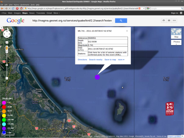
Tauranga magnitude 5.7 quake - GNS GoogleMap 051011
Tauranga magnitude 5.7 quake - GNS GoogleMap 051011


Astrolabe Reef scuba map - skaphandrus.com

Astrolabe Reef scuba map - skaphandrus.com


Map: skaphandrus.com
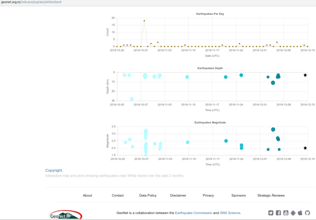
Greece and neighbouring quakes - GIM 131011 NZDT

Greece and neighbouring quakes - GIM 131011 NZDT


Source: quakes.globalincidentmap.com ~ observe
Turkey magnitude 4.4 quake - GIM 131011b

Turkey magnitude 4.4 quake - GIM 131011b


Greece quakes continue - GIM 131011c NZDT

Greece quakes continue - GIM 131011c NZDT

(N.B. Is this flood of Mediterranean area earthquake statistics due simply to addition of new seismometer feeds? …)

Quake list (follows on from) page: south-west-pacific-plate-moves-nz-quake-build