GNS Science head office, like most New Zealand government, resides in Wellington region. There, existential angst competes heavily with Auckland for economic weight and centre of gravity. So Wellington treats the South Island as a private back yard – to be seen, not heard, exploited for all it is worth and insistently ignored and mis-spoken for. ‘It is all about us’, believes the capital, almost always. This hard-to-dislodge perspective explains constant nonsense from official sources over the 14-Nov-2016 magnitude-7.8 earthquake, particularly where it actually took place (and what it did). You would think GNS could not read a map or never travelled a secondary highway, to have located this earthquake as “Culverden”. They have a convention of approximating, to name larger centres that people may have heard of, only. This generalising is unhelpful. Locating the historically-large earthquake accurately is key to understanding it and its implications.
This was a “Wairau” earthquake, as the epicentre map shows – so why aren’t the authorities saying that? Why has this earthquake become about “Wellington” and “Kaikoura” exceptionally? Yes, people have sadly died or become most isolated in the latter town, and have our condolences and full support through that, with buildings lost at both places. But this is governance by spin: intentional confusion to deflect risk – to benefit who, we may ask? Tsunami alarm and quake interpretation questions abound – what is really happening? Where is it happening? Public discourse to be urgently joined. Lives depend on getting this very public knowledge correct.
For comparison, Marlborough magnitude 5 to 6 aftershocks, 13-21 November 2016 – much fewer and smaller
Journalists often muddy the water – Cheviot earthquake: Tracing the source of the 7.5 magnitude quake “It appeared to have been a complex earthquake, and scientists were looking into whether it ruptured two separate fault planes, or whether it could be considered just a single rupture. The epicentre of the quake was close to the Hope Fault. The Kaikoura area, where the Hope Fault went offshore, was strongly affected. Despite that, the pattern of events did not necessarily suggest a Hope Fault event, [GNS Science duty seismologist Dr Anna] Kaiser said. The Hope Fault was one of the major faults through Marlborough and North Canterbury that marked the boundary between the Pacific and Australian Plates. Those faults merged near Otira to form the Alpine Fault, which ran along the western edge of the Southern Alps. Looking back over hundreds of thousands of years, the Hope Fault was considered to have one of the highest slip rates among those faults. It was an important structure in accommodating plate movement in that part of the country, Kaiser said. ‘This earthquake occurred right along that line of very active deformation.’ The Marlborough fault system was a kind of transition zone between the Alpine Fault and the subduction interface between the tectonic plates under the North Island. ‘So far, it doesn’t look to be the Hope Fault, rather (and perhaps more concerning) it seems to have ruptured across the Hope Fault,’ USGS seismologist Professor Kevin Furlong said. ‘Most/many aftershocks extend to Cook Strait, implying that the rupture may have extended quite a bit to the north. One concern is whether this has involved any of the subduction plate boundary that starts up at Kaikoura and extends along the [east coast of the] North island. At a minimum, it may have changed the stress conditions on the main megathrust interface – we are exploring that possibility right now'” – deftly shifting the focus to Wellington.
http://www.stuff.co.nz/national/86416880/cheviot-earthquake-tracing-the-source-of-the-quake 14 November 2016
Research https://www.gns.cri.nz/Home/News-and-Events/Media-Releases/Rutherford-Award 11 November 2016
Naming the river floodplains involved is extremely important as these often follow fault lines, in north Canterbury and Marlborough especially – a crucial point for understanding the moving landscape: what is moving, why and when. The Wairau event aftershock trace mostly identifies the Hope Fault, joining directly as it does the massive offshore-Kaikoura Hikurangi Trough (to the Alpine Fault). It is ultimately movement in this huge connected structure that we see affecting land. Seismic force and aftershocks moving in the direction of Wellington should not be confused with the substantive event, but they have been, influential as they are.
The zoom out illustrates two things: the offshore trench-fault that runs through land north of Kaikoura as the Hope Fault; that aftershocks are now reaching and accumulating stress along this at the Alpine Fault to the west.
GNS add to confusion – M7.8 Kaikoura quake the biggest since the Dusky Sound jolt in 2009 – 15/11/2016 “Named the Kaikoura earthquake, scientists are describing it as a complex rupture sequence that produced ground-shaking that lasted for about two minutes and was felt throughout the country. It was centered east of Hanmer Springs at a depth of 15km” https://www.gns.cri.nz/Home/News-and-Events/Media-Releases/M7.8-Kaikoura-quake 14 November 2016 – are they afraid of naming Waiau (and Hope)?
The focus is kept upon effects in the Wellington area – Seismologists record 2 metre shift south of Marlborough “The largest aftershocks were close to the Hope Fault, the line running across the centre of the map. The earth moved two metres to the north in Marlborough during Monday morning’s major earthquake, according to data from GNS Science.. the ground moved horizontally 2 metres to the north and vertically down a metre”
http://www.stuff.co.nz/national/nz-earthquake/86429681/seismologists-record-2-metre-shift-south-of-marlborough 14 November 2016 – local info presented may always be the best.
Sensational coverage becomes the fact: ‘Absolutely mind blowing’: Aerial photos ‘show seabed lift’ north of Kaikoura https://nz.news.yahoo.com/a/33218262/absolutely-mind-blowing-aerial-photos-show-seabed-lift-north-of-kaikoura/#page1 + Wellington Earthquake: If it struck at a different time, it could have been “much worse” http://www.stuff.co.nz/national/nz-earthquake/86453972/earthquake-if-it-struck-at-a-different-time-it-could-have-been-much-worse 15 November 2016
New Zealand’s Tectonic Dragon Awakens “beneath its verdant carpet, New Zealand is still under active construction. It occupies one of the most complex geologic venues on the globe, at the messy boundary of two tectonic plates.. violent, episodic upheavals that shake the seemingly tranquil hills” http://www.newyorker.com/tech/elements/new-zealands-tectonic-dragon-awakens 15 November 2016
Christchurch councils sends staff, resources to quake-hit Kaikoura https://ccc.govt.nz/the-council/newsline/show/1169 15 November 2016
GeoNet Kaikoura earthquake update: Magnitude revised http://info.geonet.org.nz/display/home/2016/11/16/Kaikoura+earthquake+update%3A+Magnitude+revised 16 November 2016 + ref. http://earthquake.usgs.gov/earthquakes/
M7.8 – 53km NNE of Amberley, New Zealand
2016-11-13 11:02:56 UTC 42.757°S 173.077°E 23.0 km depth
http://earthquake.usgs.gov/earthquakes/eventpage/us1000778i#executive +
Magnitude Mw 7.9
Region SOUTH ISLAND OF NEW ZEALAND
Date time 2016-11-13 11:02:58.4 UTC
Location 42.69 S ; 172.97 E
Depth 10 km
http://www.emsc-csem.org/Earthquake/earthquake.php?id=545040 7.9
http://www.emsc-csem.org/Earthquake/earthquake.php?id=545057 6.4
http://www.emsc-csem.org/Earthquake/earthquake.php?id=545073 6.1
http://www.emsc-csem.org/Earthquake/earthquake.php?id=545103 6.2
+ http://earthquake.usgs.gov/earthquakes/map/ (current)
While At quake’s epicentre, residents of Waiau watch helicopters destined for elsewhere “Waiau, population 280, is slowly returning to normality following the 7.8-magnitude earthquake that struck five kilometres away.. The town’s water supply has been restored but a separate feed to all rural properties was badly damaged and still broken. [Hamish] Dobbie said the council was working “really hard” to assist farmers who were running low on stock water. He hoped to have the water flowing in about a week. It has been a bitter pill to swallow for the community already struggling through a drought – a disaster within a disaster. Farmers near Waiau waved desperately at helicopters headed for Kaikoura, hoping they would stop.. It was hard not to feel forgotten as helicopters headed for Kaikoura, considering that Waiau was at the centre of it all. ‘I feel Waiau was a bit left out,” [Brenda] Smith said. ‘Even when it was first reported it was so many [kilometres] from Culverden, so many [kilometres] from Hanmer. I get it, we’re all hurting and Kaikoura is isolated … but yeah.'” http://www.stuff.co.nz/national/nz-earthquake/86594300/waiau-farmers-face-weeks-wait-for-water + Civil Defence overhaul ‘inevitable’ after tsunami warning confusion: Govt http://www.stuff.co.nz/national/86441740/civil-defence-overhaul-inevitable-after-tsunami-warning-confusion-govt + Mayor thanks those involved in evacuation effort https://ccc.govt.nz/the-council/newsline/show/1186 17 November 2016
Quake sparked more movements in Marlborough faults than first thought http://www.radionz.co.nz/news/national/318248/quake-sparked-more-movements-in-marlborough-faults-than-first-thought 17 November 2016
“Scientists know a tide gauge at Kaikoura rose 90cm during Monday’s magnitude-7.8 earthquake, but that’s one of the few pieces of detailed data so far about how much the level of the coastline has risen. There is also information about land movement from a network of continuous GPS stations run by GeoNet and Linz showing a rise of around a metre at Cape Campbell, at the southern end of Clifford Bay. Data from the stations also show Cape Campbell moved horizontally northeast by 2-3 metres. ..Many anecdotal reports suggest a two-metre rise at the coast, and there’s even one report of a reef rising six metres”
http://www.stuff.co.nz/national/86565581/finding-out-how-much-the-earth-moved-during-massive-earthquake 18 November 2016
Quake action formed Hanmer Springs but latest quake passed it by “The Hanmer Fault runs right through the township and is the noticeable rise you go up as you head north towards the pools. On the other side of the basin lies the Hope Fault, one of the major seismic features of the region which starts at the Alpine Fault near Inchbonnie on the West Coast and slices its way across North Canterbury before heading offshore just north of Kaikoura. It’s this eastern part of the Hope Fault that some scientists now believe could be at risk of rupturing if enough stress has been transferred on to it from Monday’s large quake.. GeoNet director Dr Ken Gledhill said the quake rupture took the path of least resistance northeastwards up the coast from close to Waiau where it began. ‘It’s kind of strange, it’s like the epicentre in this case is almost a meaningless concept.’ It’s where the action started but it must have started weakly and then slowly built up steam. So Hanmer just happened to be relatively close to where the epicentre, but not the real action, was. The real burst of energy that contributed to most of the magnitude was between Kaikoura and Cape Campbell. It raced up towards Cape Campbell and then it basically stopped.’ Fortunately, Cook Strait, with its offset faults, had acted like a barrier and halted the quake in its tracks, Gledhill said. It was the sudden deceleration which raised the coastal strip by up to 1 metre and shunted that part of the South Island 2m closer to Wellington, rather like a car braking sharply to a stop and the passengers being thrown suddenly up and forward. If you could create a big-enough map of the northern South Island and southern North Island you would be able to see how the islands have stretched, shrunk and otherwise changed shape since 12.02am on Monday. The quake moved Kaikoura about 1m further northeast and upwards 70 cm, and Hanmer Springs jumped east about 50 cm. Wellington and the Kapiti Coast are now 2 to 6cm further north, Christchurch and Banks Peninsula have shifted 2cm south and some parts of the West Coast are now 10cm closer to Canterbury than they were” http://www.stuff.co.nz/national/nz-earthquake/86554866/quake-action-formed-hanmer-springs-but-latest-quake-passed-it-by 18 November 2016
NIWA diverts ship to earthquake areas https://niwa.co.nz/news/niwa-diverts-ship-to-earthquake-areas 18 November 2016
CCC Coastal residents urged to have evacuation plan
https://ccc.govt.nz/the-council/newsline/show/1190

GNS Kaikoura shoreline movement, 14 Nov 2016
‘Startling’ rise of 5.5 metres in piece of coastline during Kaikoura earthquake confirms quake energy has spanned the Hope Fault – the Kekerengu Fault has just moved about 10 metres horizontally, or about half of its 20-25m known movement per 1,000 years. That much sudden, imminent movement is scarily awesome. Note the Hope Fault is near where shoreline rise has been the greatest, at 3-3.5 metres. http://www.stuff.co.nz/national/86703833/startling-rise-of-55-metres-in-piece-of-coastline-during-kaikoura-earthquake 21 November 2016
Greedy, short-sighted economic actors are multipliers of natural risk. Korean charter flights pulled post earthquake – “The tourism industry and government agencies were also deliberately calling it the ‘Kaikoura earthquake’ because referring to north Canterbury gave the impression that Christchurch had been affected, when it had not”
http://www.stuff.co.nz/business/86604299/korean-charter-flights-pulled-post-earthquake 18 November 2016
We must remember, and anticipate, the main event.
And the Wellington earthquake – in the South Island – origins.
This 7.8 was exactly where I forecast and warned of, as next in the Canterbury earthquake sequence we are – if lucky, or god will it – living through.
More information: https://www.gns.cri.nz/Home/Our-Science/Natural-Hazards/Recent-Events/Kaikoura-Earthquake
RadioNZ
There was never a risk of a tsunami, says seismologist “We are way over-playing the size and the role of tsunamis. And this is happening in a lot of other places too, because unfortunately we are in a period of science where, to get funding, you have to scare the hell out of the public.” http://www.radionz.co.nz/news/national/318338/there-was-never-a-risk-of-a-tsunami,-says-seismologist 18 November 2016
Stories from the quakes Insight http://www.radionz.co.nz/national/programmes/insight/audio/201824385/insight-earthquake-surviving-7-point-8 19 November 2016
GNS: Tsunami caught us by surprise http://www.radionz.co.nz/news/kaikoura-earthquake/318506/gns-tsunami-caught-us-by-surprise +
Govt to push for tsumani text message system http://www.radionz.co.nz/news/national/318473/govt-to-push-for-tsumani-text-message-system 20 November 2016
Civil Defence’s earthquake response to be reviewed http://www.radionz.co.nz/news/kaikoura-earthquake/318584/civil-defence’s-earthquake-response-to-be-reviewed +
Crayfish and pāua fisheries shut down on quake-hit coast http://www.radionz.co.nz/news/kaikoura-earthquake/318599/’high-and-dry,-and-now-unfortunately-rotting’ +
Quake-hit Kaikōura still isolated by road http://www.radionz.co.nz/news/kaikoura-earthquake/318538/quake-hit-kaikoura-still-isolated-by-road 21 November 2016
Minister criticises GeoNet’s funding call http://www.radionz.co.nz/news/kaikoura-earthquake/318618/minister-criticises-geonet’s-funding-call 22 November 2016
21 November 2016
Morning, Nine to Noon on http://www.radionz.co.nz News, Dr Kelvin Berryman for GNS Science discusses 14.11.2016 mag-7.8 quake fault research results and questions at variance from USGS findings (no link readily available)
This evening’s television illustrated the overwhelming interest we all have in our own local geological hazards: TV1 Seven Sharp asked ‘Is the capital in the right place?’ (lost link?); while TV3 Story looked at new research modelling of an Auckland tsunami.
22 November 2016
Scientists detect huge fault rupture offshore from Kaikoura
https://niwa.co.nz/news/scientists-detect-huge-fault-rupture-offshore-from-kaikoura
Huge fault rupture stretches 34km offshore from Kaikoura http://www.stuff.co.nz/sunday-star-times/latest-edition/latest-news/86752499/Huge-fault-rupture-stretches-34km-offshore-from-Kaikoura
The best clear explanation, through animations, of how the 7.8-magnitude earthquake propagated and exactly which faults where did move the earth, though again generalising the start as “near Culverden”:
Watching the M7.8 Kaikoura Quake Dominos Fall in Real Time
GNS M7.8 Kaikoura Quake Dominos video 2
http://info.geonet.org.nz/display/quake/2016/11/23/Watching+the+M7.8+Kaikoura+Quake+Dominos+Fall+in+Real+Time
Tremors rattle Hawke’s Bay as ‘silent earthquake’ shunts East Coast after 7.8 quake http://www.stuff.co.nz/national/86715367/Tremors-rattle-Hawkes-Bay-as-silent-earthquake-shunts-East-Coast-after-7-8-quake
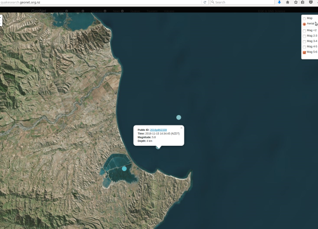
Magnitude-5.7 big aftershock that GNS generalises unhelpfully again as “Culverden” area, when it has badly affected Scargill township where a whole new quake sequence is located in their Hurunui River tributary valley. Far too vague! http://www.radionz.co.nz/news/national/318713/aftershock-damages-north-canterbury-homes
http://www.stuff.co.nz/national/86758316/Earthquake-Aftershocks-rumble-through-night-after-5-7-shake
This is what preceded the Scargill mag-5.7, by 1 minute and 23 seconds, a local foreshock of 4.8:
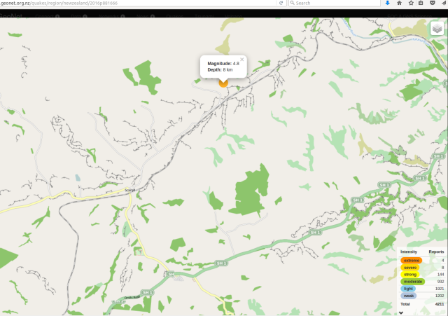
GNS screenshot 2016-11-22 Scargill 4.8-magnitude foreshock aftershock
http://www.geonet.org.nz/quakes/region/newzealand/2016p881666 83 seconds before
http://www.geonet.org.nz/quakes/region/newzealand/2016p881669 magnitude-5.7 Scargill quake
23 November 2016
The Future of New Zealand’s Coastlines
“The massive uplift after the 7.8 magnitude quake has changed Kaikoura’s coastline significantly. With a new reef forming as the land moved up, by as much as six metres along the fault plain. But do we know what the future of New Zealand’s coastline will look like? Just-published tectonic research gives some insight into what sea levels could be in the future. And the satellitle observations show parts of New Zealand, are sinking at faster rates than others, and will be subjected to higher levels of future sea level rise. Co-author of the research is Professor Tim Stern, of Victoria University’s School of Geography, Environment and Earth Sciences.” – RadioNZ Afternoons 231116
Prof Tim Stern research RadioNZ 231116
http://www.radionz.co.nz/national/programmes/afternoons/audio/201825015/the-future-of-new-zealand’s-coastlines
24 November 2016
Geonet ‘puzzled’ by aftershock sequence following the Kaikoura quake http://www.stuff.co.nz/national/86813422/geonet-puzzled-by-aftershock-sequence-following-the-kaikoura-quake
West Coast Civil Defence retracts ‘large aftershock’ warning http://www.newshub.co.nz/nznews/west-coast-warned-to-prepare-for-possible-massive-aftershock-2016112418
https://www.westlanddc.govt.nz/update-west-coast-civil-defence
http://www.wcrc.govt.nz/our-services/civil-defence-emergency-management/Pages/
Rotorua Museum closed over quake-damage concerns http://www.radionz.co.nz/news/kaikoura-earthquake/318833/rotorua-museum-closed-over-quake-damage-concerns
25 November 2016
West Coast Civil Defence aftershock warning ‘irresponsible’ – Mayor http://www.newshub.co.nz/nznews/west-coast-civil-defence-aftershock-warning-irresponsible—mayor-2016112510
Large aftershocks a possibility, but there are no ‘urgent warnings’ http://www.stuff.co.nz/national/nz-earthquake/86852615/large-aftershocks-a-possibility-but-there-are-no-urgent-warnings + Earthquake: Large aftershock urgent warning criticised “West Coast Civil Defence regional manager Chris Raine.. ‘an area in the Arthurs Pass just to the west of the divide is generating small earthquakes with several in the last few days that are being felt in Westland’.. [then CD chief] Stuart-Black said ‘Right from day one I’ve been saying that there is a likelihood that we would experience another large aftershock which could be as big as what we experienced just after midnight on 14th but could in fact be potentially larger’ http://www.stuff.co.nz/national/nz-earthquake/86863920/earthquake-large-aftershock-urgent-warning-criticised
So no news is good news? – http://www.civildefence.govt.nz/resources/declared-states-of-emergency/ – where are the official media releases from MCDEM? See https://www.facebook.com/NzGetThru/posts/1237250506334040 etc + https://www.facebook.com/CanterburyEM/
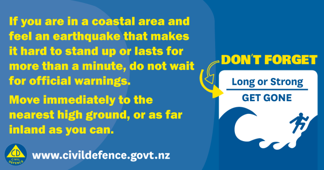
CCC – “The local state of emergency that has been in place in Canterbury for the past week has been extended until November 29” – https://ccc.govt.nz/the-council/newsline/show/1187 + “Self evacuate – don’t wait for the tsunami sirens – if it’s long or strong, get gone” – https://ccc.govt.nz/services/civil-defence/what-to-do-in-an-emergency/tsunami/evacuating/
GeoNet M7.8 Kaikoura Quake: Future Scenarios and Aftershock Forecasts Update 25 Nov 2016 15.00
“Scenario Three: Extremely unlikely (<1% within the next 30 days)
A much less likely scenario than the previous two scenarios is that recent earthquake activity will trigger an earthquake larger than the M7.8 mainshock. This includes the possibility for an earthquake of greater than M8.0, which could be on the 'plate interface' (where the Pacific Plate meets the Australian Plate). Although it is still very unlikely, the chances of this occurring have increased since before the M7.8 earthquake." http://info.geonet.org.nz/display/quake/2016/11/14/M7.8+Kaikoura+Quake%3A+Future+Scenarios+and+Aftershock+Forecasts + Stress and the earthquakes http://info.geonet.org.nz/pages/viewpage.action?pageId=20545958
26 November 2016
Central New Zealand shaken awake by magnitude 4.6 Cook Strait earthquake http://www.stuff.co.nz/national/86900233/Central-New-Zealand-shaken-awake-by-magnitude-4-6-earthquake
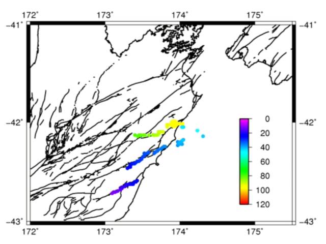
Updated: Gisborne and Hawke’s Bay slow-slip event now extends to include Kapiti and Manawatu regions following M7.8 Kaikoura Quake http://info.geonet.org.nz/display/quake/2016/11/21/Updated%3A+Gisborne+and+Hawke%27s+Bay+slow-slip+event+now+extends+to+include+Kapiti+and+Manawatu+regions+following+M7.8+Kaikoura+Quake
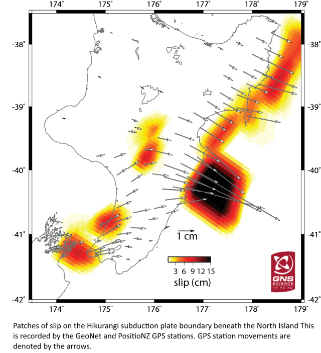
GNS slow-slip movements 26Nov2016
27 November 2016
‘Strong’ magnitude 4.8 quake rattles central New Zealand https://www.tvnz.co.nz/one-news/new-zealand/strong-magnitude-4-8-quake-rattles-central-new-zealand
28 November 2016
Three sharp earthquakes rattle central NZ, jolts continue overnight http://www.stuff.co.nz/national/nz-earthquake/86926530/Three-sharp-earthquakes-rattle-central-NZ-jolts-continue-overnight
Rotorua woken by 30m geyser eruption http://www.newshub.co.nz/nznews/rotorua-woken-by-30m-geyser-eruption-2016112810
‘The village is erupting!’ Water shot 30m into the air on Lake Rotorua, giving locals a fright https://www.tvnz.co.nz/one-news/new-zealand/village-erupting-water-shot-30m-into-air-lake-rotorua-giving-locals-fright
Rotorua geyser erupts like a shaken bottle of fizzy drink http://www.radionz.co.nz/news/national/319092/geyser-erupts-like-a-shaken-bottle-of-fizzy-drink + Geyser eruption sends water 30m into the air http://www.radionz.co.nz/national/programmes/checkpoint/audio/201825617/geyser-eruption-sends-water-30m-into-the-air
Geyser eruptions in Rotorua coincide with earthquake activity http://www.stuff.co.nz/national/86935777/Geyser-eruptions-in-Rotorua-coincide-with-earthquake-activity
Kaikoura quake could be behind ‘silent earthquakes’ http://www.radionz.co.nz/news/national/319093/kaikoura-quake-could-be-behind-‘silent-earthquakes’
Slow-slip earthquakes detected in Kapiti and Manawatu, joining Gisborne and Hawke’s Bay http://www.stuff.co.nz/national/86927682/Slow-slip-earthquakes-detected-in-Kapiti-and-Manawatu-joining-Gisborne-and-Hawkes-Bay
Watch: Incredible new images from space show how Kaikoura’s earth jolted apart https://www.tvnz.co.nz/one-news/new-zealand/watch-incredible-new-images-space-show-kaikouras-earth-jolted-apart?auto=5225981168001
29 November 2016
‘Unusual’ geothermal activity at Lake Rotorua – GNS
http://www.newshub.co.nz/nznews/unusual-geothermal-activity-at-lake-rotorua-2016112823
Are earthquakes and geyser eruptions related? ‘No, Taupo and Tarawera eruptions have a roughly 1,000 year return period, Auckland every 1-2,000 years..’
http://www.newshub.co.nz/tvshows/paulhenry/are-earthquakes-and-geyser-eruptions-related-2016112913
Scientists’ research trench slips nine metres in Kaikoura Earthquake http://www.stuff.co.nz/science/86972668/scientists-research-trench-slips-nine-metres-in-kaikoura-earthquake
30 November 2016
Another geyser erupts in Rotorua
http://www.newshub.co.nz/nznews/another-geyser-erupts-in-rotorua-2016113015
Weather might have caused second eruption in Rotorua http://www.radionz.co.nz/news/national/319291/weather-might-have-caused-second-eruption-in-rotorua
Become better prepared – https://happens.nz
This USGS shake-intensity map locates: a) the Pacific plate and Australian plate tectonic boundary; b) Wairau River as central to the mag-7.8 EQ fault action – confirmed (therefore USGS have this epicentre listed wrongly?)
Synchronicity with Alpine Fault movement is precise – “at least three past large earthquakes had occurred in the last 1250 years. These initial results confirmed that the Kekerengu Fault was capable of producing large earthquakes frequently (on average, about every 300 or 400 hundred years)” – how long delayed is the M7.8 Waiau flow-on effect, to an Alpine M8-9, being the only question. As in weeks, months, years or decades? … Further large stress input is not needed. – Kekerengu Fault has a Word to its Geologists http://info.geonet.org.nz/display/quake/2016/11/28/Kekerengu+Fault+has+a+Word+to+its+Geologists
1 December 2016
“Kēkerengū Fault.. in the last 1200 years.. this fault has ruptured three times – and now it’s the fourth time.. between 30 and 50 percent chance of having a great earthquake on the Alpine Fault in the next 50 years”
Fault unlocks new geological data
http://www.radionz.co.nz/news/national/319319/fault-unlocks-new-geological-data
Warnings sounded over NZ’s Transport resilience http://www.radionz.co.nz/national/programmes/ninetonoon/audio/201826002/warnings-sounded-over-nz’s-transport-resilience
Giant underwater landslide in the Kaikōura Canyon http://www.radionz.co.nz/national/programmes/ourchangingworld/audio/201825860/giant-underwater-landslide-in-the-kaik-ura-canyon
Slow slips could raise quake risk: GeoNet http://www.newshub.co.nz/nznews/slow-slips-could-raise-quake-risk-geonet-2016120117
“GNS volcanologist Brad Scott says the geyser was more likely due to weather than to seismic activity” Geyser erupts for second time in Lake Rotorua http://www.radionz.co.nz/national/programmes/morningreport/audio/201825984/geyser-erupts-for-secnd-time-in-lake-rotorua
2 December 2016
Lake Rotorua eruptions ‘not related’ to M7.8, say GNS.. despite its very long reach? :
Earthquake leaves Rotorua Museum closed ‘until further notice‘
http://www.newshub.co.nz/nznews/earthquake-leaves-rotorua-museum-closed-until-further-notice-2016120214
September 2015, one year ago: Rotorua geyser bursts into life after 35 years http://www.radionz.co.nz/national/programmes/checkpoint/audio/201769992/rotorua-geyser-bursts-into-life-after-35-years + in sequence before that:
Seismic studies shed light on natural disaster risk “the build-up to an eruption from Auckland’s volcanos would be more accelerated than those for volcanos elsewhere” http://www.radionz.co.nz/news/national/59423/seismic-studies-shed-light-on-natural-disaster-risk 13 October 2010 [then 4.9.2010, 22.2.2011 etc Canterbury quakes..]
New lakes formed by Mt Tongariro’s eruption http://www.radionz.co.nz/news/national/112694/new-lakes-formed-by-mt-tongariro’s-eruption 8 August 2012
New crater blasted on White Island http://www.radionz.co.nz/news/regional/302697/new-crater-blasted-on-white-island 30 April 2016
Mt Ruapehu still shaking http://www.radionz.co.nz/news/national/303667/mt-ruapehu-still-shaking 12 May 2016
Scientists prepare for Lake Taupo eruption http://www.radionz.co.nz/news/regional/305214/scientists-prepare-for-lake-taupo-eruption 30 May 2016
+ Preceding the 14.11.2016 mag-7.8 was Hydrothermal activity in Lake Rotorua “A collaboration between the New Zealand Defence Force and GNS Science has picked up hydrothermal activity in Lake Rotorua.. ‘This work is the first step in a series of surveys that we hope will ultimately determine how much heat is being discharged through the lake floor from an underlying magma source, with the results feeding into our long-term hazards assessment of the area.’ The six-week survey ends next week. It covered about 40 percent of the lake floor.” http://www.radionz.co.nz/news/national/317947/hydrothermal-activity-in-lake-rotorua 12 November 2016
4 December 2016
Kaikōura’s new coast shown by NASA photos http://www.radionz.co.nz/news/national/319560/kaikoura’s-new-coast-shown-by-nasa-photos
7 December 2016
Nine faults ruptured in Kaikoura quake “but the Hope Fault barely moved.. there could be three segments to the Hope Fault, which moved about 10cm at Half Moon Bay.. GNS was in the process of building a map of the faults” http://www.radionz.co.nz/news/national/319798/nine-faults-ruptured-in-kaikoura-quake
10 faults known to have ruptured in Kaikoura quake, more likely “The quake started with the rupture of the Humps Fault Zone, near Culverden, [Dr Nicola Litchfield, head of the GNS Science active landscapes department].. said. That seemed to have triggered the next fault along, which had triggered the next one and so on all the way to the Needles Fault – the offshore continuation of the Kekerengu Fault. ‘The movement in each of those [faults] was big enough it triggered the next to go in the same earthquake,’ she said. The faults that went must have been ready to go. The large Hope Fault hadn’t ruptured. “Basically it jumped over the Hope Fault and didn’t rupture that except for a tiny bit at the coast,” Litchfield said. ‘In this area there are a lot of faults. The thing is before this earthquake we didn’t think so many were going to rupture in one earthquake. I guess that’s the big surprise.’ It was unlikely the combination of faults in the Kaikoura earthquake would be repeated. The Kekerengu Fault went every 300-400 years. In contrast, it wasn’t known how often the faults at the south of the rupture zone went, but it was thought to be thousands, or tens of thousands of years between ruptures.”
http://www.stuff.co.nz/science/87292211/10-faults-known-to-have-ruptured-in-kaikoura-quake-more-likely
9 December 2016
Central NZ tsunami risk may be higher due to undiscovered offshore faults “GNS Science geophysicist Dr William Power said the 14 November tremor provided an ‘interesting puzzle’ in terms of where the tsunami was generated.. the tsunami might have reached 4 metres in some areas of the Kaikoura coast. However, the fact the quake struck close to low tide and that the land was uplifted at the same time reduced the extent of inundation. ‘A better understanding of the fault movements offshore in the Kaikoura earthquake will help us better evaluate the tsunami risks in central New Zealand.'”
http://www.stuff.co.nz/national/nz-earthquake/87301480/central-nz-tsunami-risk-may-be-higher-due-to-undiscovered-offshore-faults
15 December 2016
Restrictions on building along Alpine Fault in Franz Josef scrapped
http://www.stuff.co.nz/national/87604696/restrictions-on-building-along-alpine-fault-in-franz-josef-scrapped
16 December 2016
Scientists find evidence the Earth’s crust ripped apart to create a 7km deep abyss off Banda, Indonesia http://www.stuff.co.nz/science/87647721/scientists-find-evidence-the-earths-crust-ripped-apart-to-create-a-7km-deep-abyss
[post under edit – return to read more later – thanks for viewing]
M7.8 Kaikoura quake the biggest since the Dusky Sound jolt in 2009 – 15/11/2016
https://www.gns.cri.nz/Home/News-and-Events/Media-Releases/M7.8-Kaikoura-quake
Canterbury Earthquake Research Programme 2012-15 “In Budget 2011, Government made available to the Platform $12M GST ex for studies that addressed the impacts of the Canterbury earthquakes and lessons that could be applied to other centres” – So why stop there? …
https://www.naturalhazards.org.nz/NHRP/Publications/Establishment-Strategy/Canterbury-EQ-Programme
NZ moving to ‘period of more earthquakes’ 15 November 2016
http://www.radionz.co.nz/news/national/318095/nz-moving-to-‘period-of-more-earthquakes’
The Mountains Moved 00.02 14.11.2016
https://assets.stuff.co.nz/interactives/special-features/the-mountains-moved/index.html
Quake claims top $900m “New Zealand businesses have lodged more than $900 million in insurance claims since the Kaikōura earthquake”
http://www.radionz.co.nz/news/business/323574/quake-claims-top-$900m
Did November’s 7.8 shake create a ‘quake lake’ in the Tararuas? 20 March 2017
http://www.stuff.co.nz/environment/90608086/Did-Novembers-7-8-shake-create-a-quake-lake-in-the-Tararuas
Large earthquake risk remains high “15 percent likelihood of a magnitude 6.0 or higher earthquake striking New Zealand in the next month” 20 March 2017
http://www.radionz.co.nz/news/national/327036/large-earthquake-risk-remains-high
Quake-hit residents fear insurance woes 24 March 2017
http://www.radionz.co.nz/news/national/327322/quake-hit-residents-fear-insurance-woes
Major earthquake could split Wellington region into ‘seven islands’ 24 March 2017
http://www.stuff.co.nz/national/nz-earthquake/90790889/Major-earthquake-could-split-Wellington-region-into-seven-islands
Kaikoura earthquake moved the South Island, new research shows 24 March 2017
http://www.stuff.co.nz/science/90769048/kaikoura-earthquake-moved-the-south-island-new-research-shows
Kaikōura quake moved South Island 5 metres 24 March 2017
http://www.radionz.co.nz/news/national/327328/kaikoura-quake-moved-south-island-5-metres
Extreme heat detected beneath the Southern Alps “New Zealand scientists drilling into the Alpine Fault on the West Coast have found much higher temperatures than expected – which as well as being scientifically exciting could also be commercially very significant for New Zealand. They’ve drilled nearly 900 metres into the Alpine Fault at Whataroa – finding geothermal conditions comparable with Taupo, but there are no volcanoes in Westland. Kathryn Ryan talks to Victoria University’s John Townend” RNZ 18 May 2017
http://www.radionz.co.nz/national/programmes/ninetonoon/audio/201844259/extreme-heat-detected-beneath-the-southern-alps
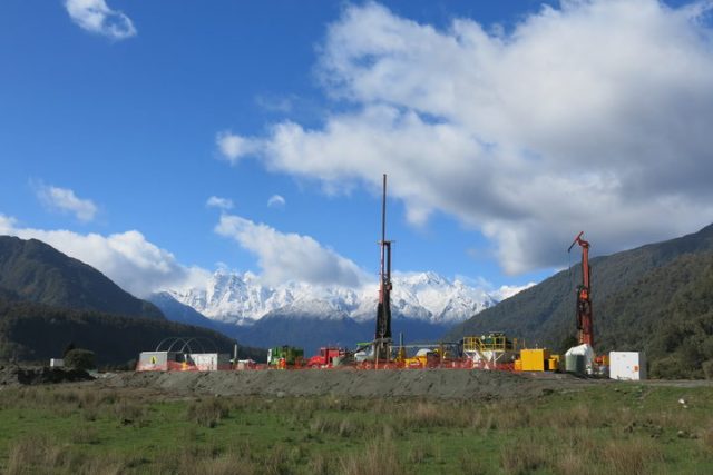
Whataroa Valley research site at Alpine Fault – Victoria University supplied pic, May 2017
+
The sleeping dragon: Researchers find blazing heat beneath the Southern Alps The Press
http://www.stuff.co.nz/environment/92669729/the-sleeping-dragon-researchers-find-blazing-heat-beneath-the-southern-alps